Point Pleasant Creek facts for kids
Quick facts for kids Point Pleasant Creek |
|
|---|---|

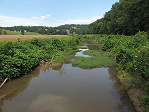
Point Pleasant Creek in Kidwell
|
|

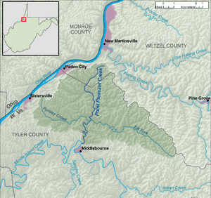
A map of Point Pleasant Creek and its watershed
|
|
| Country | United States |
| State | West Virginia |
| Counties | Wetzel, Tyler |
| Physical characteristics | |
| Main source | south of New Martinsville, Wetzel County 987 ft (301 m) 39°36′40″N 80°51′48″W / 39.6111883°N 80.8634343°W |
| River mouth | Middle Island Creek Middlebourne, Tyler County 663 ft (202 m) 39°30′13″N 80°54′10″W / 39.5036887°N 80.9028846°W |
| Length | 10.4 mi (16.7 km) |
| Basin features | |
| Basin size | 60.5 sq mi (157 km2) |
| Tributaries |
|
| Hydrologic Unit Codes | 050302010502, 050302010503 (USGS) |
Point Pleasant Creek is a small river, about 10.4 miles (16.7 kilometers) long. It flows through the northwestern part of West Virginia in the United States. This creek is a tributary, which means it's a smaller stream that flows into a larger one. Point Pleasant Creek joins Middle Island Creek.
Eventually, its water travels through Middle Island Creek into the Ohio River. From there, it flows into the mighty Mississippi River. This whole area that the creek drains is called its watershed. Point Pleasant Creek's watershed covers about 60.5 square miles (156.7 square kilometers). It's located in a rural area of the Allegheny Plateau.
Contents
Where Does Point Pleasant Creek Start?
Point Pleasant Creek begins in the southwestern part of Wetzel County. This starting point is about 2 miles (3.2 kilometers) south of a town called New Martinsville.
The Creek's Journey
From its source, the creek flows south. It crosses into Tyler County. Along its path, it passes through a small community named Kidwell. Near Kidwell, the creek gets bigger because another stream joins it. This joining stream is its largest tributary, called the Elk Fork.
Where the Creek Ends
Point Pleasant Creek continues its journey until it reaches the northern edge of the town of Middlebourne. Here, it flows into Middle Island Creek, marking the end of its journey as a separate stream.
Roads Along the Creek
For part of its length, West Virginia Route 180 runs right next to Point Pleasant Creek. This is true for the section upstream of Kidwell. For the rest of its path, the creek is mostly next to West Virginia Route 18.
 | Ernest Everett Just |
 | Mary Jackson |
 | Emmett Chappelle |
 | Marie Maynard Daly |

