Arnold Creek (West Virginia) facts for kids
Quick facts for kids Arnold Creek |
|
|---|---|

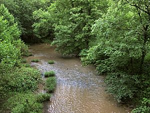
Arnold Creek in Doddridge County
|
|

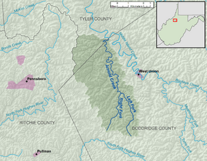
A map of Arnold Creek and its watershed
|
|
| Country | United States |
| State | West Virginia |
| Counties | Doddridge, Tyler |
| Physical characteristics | |
| Main source | Left Fork Arnold Creek west-northwest of Middle Point, Doddridge County 1,100 ft (340 m) 39°12′46″N 80°47′16″W / 39.2128626°N 80.7878823°W |
| 2nd source | Right Fork Arnold Creek northeast of Oxford, Doddridge County 1,045 ft (319 m) 39°13′10″N 80°49′48″W / 39.2195282°N 80.8301056°W |
| River mouth | Middle Island Creek east-northeast of Deep Valley 728 ft (222 m) 39°20′36″N 80°49′45″W / 39.3434149°N 80.8292723°W |
| Length | 10.9 mi (17.5 km) |
| Basin features | |
| Basin size | 34.7 sq mi (90 km2) |
| Hydrologic Unit Code | 050302010405 (USGS) |
Arnold Creek is a small river, about 10.9 miles (17.5 km) long, located in West Virginia, United States. It flows into Middle Island Creek. From there, its waters eventually join the Ohio River and then the mighty Mississippi River.
This means Arnold Creek is part of a huge watershed. A watershed is like a giant funnel. All the rain and snow that falls in this area (about 34.7 square miles (90 km2)) eventually flows into Arnold Creek. The land around it is a rural area on the Allegheny Plateau, which was not shaped by glaciers.
Contents
Where Arnold Creek Starts
Arnold Creek begins in western Doddridge County. It forms when two smaller streams, called "forks," meet. This meeting point is about 2.4 miles (3.9 km) southwest of West Union.
Left Fork Arnold Creek
- The Left Fork Arnold Creek is about 4.9 miles (7.9 km) long.
- It starts in Doddridge County.
- Its source is about 2.2 miles (3.5 km) west-northwest of Middle Point.
- This fork generally flows towards the north.
Right Fork Arnold Creek
- The Right Fork Arnold Creek is about 4.6 miles (7.4 km) long.
- It also begins in Doddridge County.
- Its source is about 2.1 miles (3.4 km) northeast of Oxford.
- This fork flows towards the northeast.
Arnold Creek's Journey
After the Left and Right Forks join, Arnold Creek flows generally northward. It stays mostly within western Doddridge County.
Near its end, the creek briefly enters southern Tyler County. Then it returns to Doddridge County. Finally, Arnold Creek flows into Middle Island Creek from the south. This happens right on the border of Doddridge and Tyler counties. This spot is about 0.9 miles (1.4 km) east-northeast of a small community called Deep Valley.
Historically, Arnold Creek has also been known by a slightly different spelling: "Arnolds Creek." This information comes from the Geographic Names Information System.
Tributaries
Arnold Creek has many smaller streams that flow into it. These are called tributaries. This list shows the named streams in Arnold Creek's watershed. They are listed starting from the ones closest to Arnold Creek's mouth (where it ends) and going upstream towards its source (where it begins).
| Name | Flows into | Length | Mouth coordinates | Source coordinates | |
|---|---|---|---|---|---|
| 1 | Short Run | Arnold Creek | 2.4 miles (3.9 km) | 39°20′22″N 80°50′19″W / 39.339526°N 80.838717°W | 39°19′23″N 80°53′20″W / 39.323136°N 80.888996°W |
| 2 | Long Run | Arnold Creek | 4.1 miles (6.6 km) | 39°19′32″N 80°49′57″W / 39.325637°N 80.832606°W | 39°17′39″N 80°53′08″W / 39.294248°N 80.885663°W |
| 3 | Mudlick Run | Long Run | 1.6 miles (2.6 km) | 39°18′37″N 80°51′18″W / 39.310359°N 80.855106°W | 39°19′01″N 80°53′18″W / 39.317025°N 80.88844°W |
| 4 | Hugle Run | Long Run | 1.4 miles (2.3 km) | 39°18′21″N 80°51′21″W / 39.305915°N 80.85594°W | 39°17′54″N 80°53′14″W / 39.298415°N 80.887329°W |
| 5 | Lick Run | Arnold Creek | 1.3 miles (2.1 km) | 39°18′41″N 80°49′51″W / 39.311471°N 80.830939°W | 39°18′22″N 80°50′52″W / 39.306111°N 80.847778°W |
| 6 | Rock Run | Arnold Creek | 1.5 miles (2.4 km) | 39°18′23″N 80°49′25″W / 39.306471°N 80.823717°W | 39°18′24″N 80°48′22″W / 39.306667°N 80.806111°W |
| 7 | Wilhelm Run | Arnold Creek | 3.5 miles (5.6 km) | 39°17′42″N 80°49′18″W / 39.295082°N 80.821772°W | 39°16′08″N 80°52′00″W / 39.268889°N 80.866667°W |
| 8 | Claylick Run | Arnold Creek | 3.7 miles (6.0 km) | 39°16′49″N 80°48′51″W / 39.280361°N 80.814272°W | 39°15′43″N 80°51′38″W / 39.261944°N 80.860556°W |
| 9 | Pritchard Run | Arnold Creek | 2.0 miles (3.2 km) | 39°16′38″N 80°48′44″W / 39.277305°N 80.812328°W | 39°16′05″N 80°47′27″W / 39.268056°N 80.790833°W |
| 10 | Middle Run | Arnold Creek | 2.1 miles (3.4 km) | 39°16′19″N 80°48′44″W / 39.272028°N 80.812328°W | 39°14′22″N 80°50′44″W / 39.239528°N 80.845662°W |
| 11 | Right Fork Arnold Creek | Arnold Creek | 4.6 miles (7.4 km) | 39°16′16″N 80°48′26″W / 39.271194°N 80.807328°W | 39°13′10″N 80°49′48″W / 39.219528°N 80.830106°W |
| 12 | Left Fork Arnold Creek | Arnold Creek | 4.9 miles (7.9 km) | 39°16′16″N 80°48′26″W / 39.271194°N 80.807328°W | 39°12′46″N 80°47′16″W / 39.212863°N 80.787882°W |
 | James Van Der Zee |
 | Alma Thomas |
 | Ellis Wilson |
 | Margaret Taylor-Burroughs |

