Meathouse Fork facts for kids
Quick facts for kids Meathouse Fork |
|
|---|---|

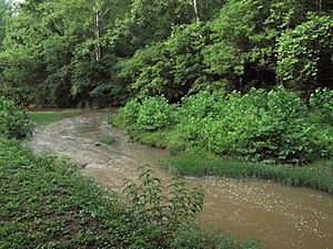
Meathouse Fork south of Smithburg, West Virginia
|
|

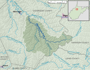
A map of the Meathouse Fork and its watershed
|
|
| Country | United States |
| State | West Virginia |
| County | Doddridge |
| Physical characteristics | |
| Main source | Big Isaac Creek southeast of Miletus 1,190 ft (360 m) 39°13′09″N 80°34′34″W / 39.2191667°N 80.5761111°W |
| 2nd source | Laurel Run northeast of Big Isaac 1,154 ft (352 m) 39°12′38″N 80°31′58″W / 39.2105556°N 80.5327778°W |
| River mouth | Middle Island Creek Smithburg 794 ft (242 m) 39°17′03″N 80°43′41″W / 39.2842512°N 80.7281587°W |
| Length | 19.7 mi (31.7 km) |
| Basin features | |
| Basin size | 64.6 sq mi (167 km2) |
| Tributaries |
|
| Hydrologic Unit Codes | 050302010401, 050302010403 (USGS) |
The Meathouse Fork is a river in West Virginia, United States. It's about 19.7 miles (31.7 km) long. This river is a tributary, which means it's a smaller stream that flows into a larger one. The Meathouse Fork flows into Middle Island Creek.
From Middle Island Creek, its water travels to the Ohio River. Then, the Ohio River flows into the mighty Mississippi River. This means the Meathouse Fork is part of the huge watershed of the Mississippi River. It helps drain an area of 64.6 square miles (167 km²) in a rural part of the Allegheny Plateau.
Contents
Where the Meathouse Fork Flows
The entire path of the Meathouse Fork and the land it drains are located in Doddridge County. This county is in the southern and central parts of West Virginia.
How the River Starts
The Meathouse Fork begins in the southeastern part of Doddridge County. It's formed when two smaller streams meet:
- Big Isaac Creek: This creek is about 2 miles (3.2 km) long. It starts near the town of Miletus and flows southeast.
- Laurel Run: This stream is about 1.6 miles (2.6 km) long. It begins near the town of Big Isaac and flows west, right through Big Isaac.
These two streams join together about 0.9 miles (1.4 km) west of Big Isaac.
The River's Journey
After Big Isaac Creek and Laurel Run meet, the Meathouse Fork generally flows northwest. Along its way, it passes through several small communities. These include Avon, New Milton, Sugar Camp, and Blandville.
Finally, the Meathouse Fork reaches Smithburg. Here, it joins another stream called Buckeye Creek. When these two rivers meet, they form the larger Middle Island Creek.
River Branches and Roads
The Meathouse Fork has a main branch, or tributary, called Toms Fork. Toms Fork joins the Meathouse Fork near Sugar Camp. In the areas around Sugar Camp and Blandville, the river flows next to West Virginia Route 18.
Why is it Called Meathouse Fork?
The name "Meathouse Fork" has an interesting story! The first European settlers came to this area in the 1820s. A local historian, about a hundred years later, explained how the name came to be.
Hunters from other places would come to this area to hunt deer and bear. They built a small log cabin where they could store the meat they caught. This way, they could keep it safe until they were ready to take it back home. This special cabin was called a "meat house."
Because of this meat house, the part of Middle Island Creek that stretches from near Smithburg to Big Isaac became known as the "Meat House Fork."
 | Madam C. J. Walker |
 | Janet Emerson Bashen |
 | Annie Turnbo Malone |
 | Maggie L. Walker |

