Toms Fork facts for kids
Quick facts for kids Toms Fork |
|
|---|---|

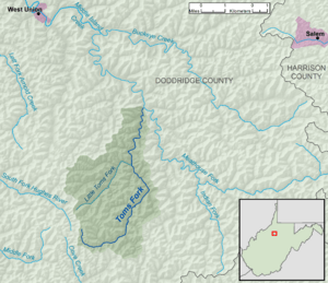
A map of Toms Fork and its watershed
|
|
| Country | United States |
| State | West Virginia |
| County | Doddridge |
| Physical characteristics | |
| Main source | southeast of Porto Rico 1,229 ft (375 m) 39°10′01″N 80°44′28″W / 39.1669444°N 80.7411111°W |
| River mouth | Meathouse Fork Sugar Camp 810 ft (250 m) 39°14′24″N 80°41′37″W / 39.2400859°N 80.6937130°W |
| Length | 9.3 mi (15.0 km) |
| Basin features | |
| Basin size | 15.5 sq mi (40 km2) |
| Hydrologic Unit Code | 050302010401 (USGS) |
Toms Fork is a small stream, also called a tributary, located in north-central West Virginia in the United States. It flows into a larger stream called the Meathouse Fork. Toms Fork is about 9.3 miles (15.0 km) long.
This stream is part of a much bigger water system. Its water eventually flows into the Middle Island Creek, then the Ohio River, and finally the mighty Mississippi River. This whole area, where all the water drains into Toms Fork and then these larger rivers, is called a watershed. Toms Fork's watershed covers about 15.5 square miles (40 km2) of land. This area is mostly rural and is part of the Allegheny Plateau, a high, flat region that was not covered by glaciers long ago.
Where Does Toms Fork Flow?
Toms Fork is entirely located within the southern part of Doddridge County, West Virginia. It begins its journey about 1.6 miles (2.6 km) southeast of a small, unincorporated community called Porto Rico.
The stream generally flows towards the north-northeast. Along its path, it passes through another small community known as Market.
Meeting Other Streams
Toms Fork continues its journey until it reaches Sugar Camp. Here, it flows into the Meathouse Fork, joining its waters.
For most of its length, Toms Fork runs right alongside West Virginia Route 18. This means you can often see the stream if you are traveling on that road. At Market, Toms Fork collects water from its biggest smaller stream, which is called Little Toms Fork.
 | Chris Smalls |
 | Fred Hampton |
 | Ralph Abernathy |

