Thiruvananthapuram district facts for kids
Thiruvananthapuram District is a special place in the southern part of Kerala, a beautiful coastal state in India. It's home to the biggest city in Kerala, also called Thiruvananthapuram (or Trivandrum). This city is the capital of Kerala.
The district was created in 1957. It covers an area of about 2,192 square kilometers (846 square miles). In 2011, about 3.3 million people lived here, making it the second most populated district in Kerala. It's also the most crowded district, with many people living close together.
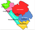
The district is divided into six smaller areas called taluks. These are Thiruvananthapuram, Chirayinkeezhu, Neyyattinkara, Nedumangadu, Varkala, and Kattakada. There are also several important towns and cities, including Thiruvananthapuram (a big city), Varkala, Neyyattinkara, Attingal, and Nedumangad.
Contents
People and Population
In 2011, the Thiruvananthapuram district had a population of about 3,307,284 people. This number is similar to the population of a country like Uruguay! It means Thiruvananthapuram was the 103rd most populated district out of 640 districts in India.
The district is quite crowded, with about 1,509 people living in every square kilometer. Between 2001 and 2011, the population grew by about 2.25%. For every 1000 boys, there were 1088 girls, which is a good sign. Also, a high number of people, about 92.66%, could read and write, showing a strong focus on education.
Exploring Thiruvananthapuram
Thiruvananthapuram district offers many interesting places to visit and things to learn about. From ancient temples to beautiful beaches, there's something for everyone.
Famous Landmarks
The district is home to several well-known spots. One of the most famous is the Sree Padmanabhaswamy temple. This ancient temple is known for its amazing architecture and history.
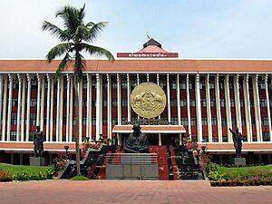
Another popular place is Varkala, which has unique cliffs right next to the Arabian Sea. It's a rare sight in southern Kerala. The district also has important buildings like the Kerala University administrative building.
Natural Beauty
If you love nature, Thiruvananthapuram has a lot to offer. The coastal areas, like Kovalam, are famous for their stunning beaches. You can enjoy the sun and sand there.
The hilly parts of the district are great for farming. Many aromatic plants and spices, like pepper, are grown here. This shows the rich natural resources of the area.
Sports and Recreation
For sports fans, there are places like the Chandrashekaran Nair Football Stadium. This stadium is a place where local teams play and people gather to watch exciting matches.
Images for kids
-
Cliffs at Varkala, Thiruvanatnthapuram district, the only place in southern Kerala with cliffs adjacent to the Arabian Sea
See also
 In Spanish: Distrito de Thiruvananthapuram para niños
 | William L. Dawson |
 | W. E. B. Du Bois |
 | Harry Belafonte |


