Thundersbarrow Hill facts for kids

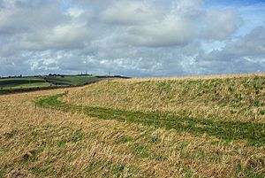
Looking north along the west side of the hillfort
|
|
| Location | West Sussex, near Shoreham-by-Sea |
|---|---|
| Coordinates | 50°51′43″N 0°15′17″W / 50.86194°N 0.25472°W |
| History | |
| Periods | Bronze Age Iron Age Romano-British |
| Designated | 26 March 1934 |
| Reference no. | 1015124 |
Thundersbarrow Hill is an amazing ancient site in West Sussex, England. It sits on a chalk ridge, which is a long, narrow hill, on the South Downs. This special place is north of Shoreham-by-Sea.
At Thundersbarrow Hill, you can find traces of different time periods. There's an Iron Age hillfort, which was like an ancient walled town. You can also see a bowl barrow and an enclosure from the Bronze Age. Later, a Romano-British farming village was built here. This whole site is protected as a scheduled monument.
Contents
What is Thundersbarrow Hill?
Thundersbarrow Hill is an important archaeological site. This means it's a place where people study the past by digging up old objects and structures. Experts have done some digging here. E. C. Curwen led an excavation in 1932. Later, D. Rudling did more work in 1985. These digs helped us learn about the people who lived here long ago.
The Iron Age Hillfort
Imagine a big, round fort built on top of a hill! That's what the hillfort at Thundersbarrow Hill was like. It covers an area of about 1.33 hectares. The eastern side has been flattened by farming over many years. But the western side still has a bank that's about 1 meter high.
Originally, there was a ditch around the fort, about 7 meters wide. This ditch is now filled in. The fort had two entrances: one on the north side and another on the south-east side. Scientists looked at pieces of pottery found here. They believe the fort was built around 600 BC and used until about 250 BC.
Bronze Age Enclosure
Inside the hillfort, there's an older area called a Martin Down style enclosure. It's named after a similar site in Hampshire. This enclosure was likely a place where people lived during the Bronze Age. It's roughly square, with sides about 70 meters long. This area is about 0.49 hectares. Farming has made it almost flat now.
This enclosure also had two entrances, one on the west and one on the east, each about 6 meters wide. By studying pottery pieces from its old ditch, experts think this settlement was used around 1000 BC to 900 BC.
The Bronze Age Burial Mound
About 10 meters south-east of the fort, there's a Bronze Age bowl barrow. It's known as Thunders Barrow. A "barrow" is a mound of earth built over a burial site. This barrow was disturbed a couple of times. First, when a pond was created in 1873. Then, when earth was moved in 1964.
Today, you can still see a semi-circular mound. It's about 17 meters wide and up to 2 meters high. It's a reminder of how people buried their dead thousands of years ago.
The Romano-British Village
To the east and north of the fort, there are hidden remains of a Romano-British village. This means people lived here when the Romans were in Britain. During the 1932 dig, archaeologists found rectangular houses. These houses were about 5 meters long and 3.5 meters wide.
They also found old coins and pottery pieces. These items show that the village was active from about AD 50 to AD 400. Around the village, over a large area of about 40 hectares, you can still see traces of ancient fields. These fields were used by the villagers. They appear as small earthworks, about 0.5 meters high, or as marks on the ground that can be seen from the air. Most of these fields were rectangular, each about 0.35 hectares in size.
 | Janet Taylor Pickett |
 | Synthia Saint James |
 | Howardena Pindell |
 | Faith Ringgold |


