Tiaret Province facts for kids
Quick facts for kids
Tiaret Province
ولاية تيارت
|
|
|---|---|

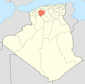
Map of Algeria highlighting Tiaret
|
|
| Country | |
| Capital | Tiaret |
| Area | |
| • Total | 20,673 km2 (7,982 sq mi) |
| Population
(2008)
|
|
| • Total | 842,060 |
| • Density | 40.7324/km2 (105.496/sq mi) |
| Time zone | UTC+01 (CET) |
| Area Code | +213 (0) 46 |
| ISO 3166 code | DZ-14 |
| Districts | 14 |
| Municipalities | 42 |
Tiaret is a province in Algeria, a country in North Africa. Its capital city is also called Tiaret. This province is known for its rich history and beautiful landscapes. It is located in the western part of Algeria.
Understanding Tiaret Province
Tiaret Province covers a large area of about 20,673 square kilometers. That's roughly the size of a small country! In 2008, about 842,060 people lived here. The province is divided into smaller areas to help manage it.
How Tiaret Province is Organized
Tiaret Province is split into 14 main areas called districts. These districts help organize the local government and services. Inside these districts, there are even smaller areas called communes or municipalities. There are 42 of these municipalities in total.
List of Districts
Here are the 14 districts that make up Tiaret Province:
- Aïn Deheb
- Aïn Kermes
- Dahmouni
- Frenda
- Hamadia
- Ksar Chellala
- Mahdia
- Mechraâ Sfa
- Medroussa
- Meghila
- Oued Lili
- Rahouia
- Sogueur
- Tiaret
See also
 You can also find information about Tiaret Province in Spanish: Provincia de Tiaret para niños
 | Lonnie Johnson |
 | Granville Woods |
 | Lewis Howard Latimer |
 | James West |

