Tipasa Province facts for kids
Quick facts for kids
Tipaza Province
ولاية تيبازة
|
|
|---|---|

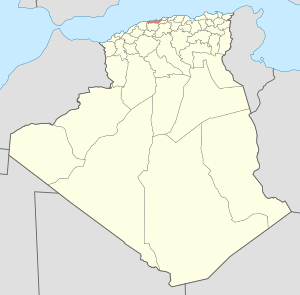
Map of Algeria highlighting Tipaza
|
|
| Country | |
| Capital | Tipaza |
| Area | |
| • Total | 2,166 km2 (836 sq mi) |
| Population | |
| • Total | 617,661 |
| • Density | 285.16/km2 (738.57/sq mi) |
| Time zone | UTC+01 (CET) |
| Area Code | +213 (0) 24 |
| ISO 3166 code | DZ-42 |
| Districts | 10 |
| Municipalities | 28 |
Tipaza Province is a beautiful region located on the coast of Algeria, a country in North Africa. It is also sometimes called Tipasa Province. This area is known for its stunning views of the Mediterranean Sea.
The main city and capital of Tipaza Province is Tipasa. This important city is about 50 kilometers (31 miles) west of Algiers, which is the capital city of Algeria.
Contents
About Tipaza Province
Tipaza Province covers a total area of 2,166 square kilometers (about 836 square miles). In 2008, about 617,661 people lived in this province. This makes it a lively place with many towns and communities.
How is Tipaza Province Organized?
To help manage the region, Tipaza Province is divided into smaller areas. These areas help local governments serve the people better. The province has 10 main districts. Within these districts, there are 28 smaller areas called communes or municipalities. Think of communes as towns or local communities.
Districts of Tipaza Province
Here are the 10 districts that make up Tipaza Province:
- Ahmer El Aïn
- Bou Ismaïl
- Cherchell
- Damous
- Fouka
- Gouraya
- Hadjout
- Koléa
- Sidi Amar
- Tipaza
See also
 In Spanish: Provincia de Tipasa para niños
 | Victor J. Glover |
 | Yvonne Cagle |
 | Jeanette Epps |
 | Bernard A. Harris Jr. |

