Tissemsilt Province facts for kids
Quick facts for kids
Tissemsilt Province
ولاية تسمسيلت
|
|
|---|---|

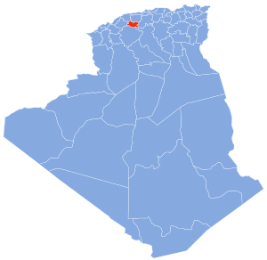
Map of Algeria highlighting Tissemsilt
|
|
| Country | |
| Capital | Tissemsilt |
| Area | |
| • Total | 3,152 km2 (1,217 sq mi) |
| Population
(2008)
|
|
| • Total | 296,366 |
| • Density | 94.025/km2 (243.52/sq mi) |
| Time zone | UTC+01 (CET) |
| Area Code | +213 (0) 46 |
| ISO 3166 code | DZ-38 |
| Districts | 8 |
| Municipalities | 22 |
Tissemsilt is a province in Algeria, a country in North Africa. A province is like a large region or state within a country. The main city and capital of this province is also called Tissemsilt. This area is known for its beautiful nature, including Théniet El Haâd National Park.
About Tissemsilt Province
Tissemsilt Province is located in the northern part of Algeria. It covers an area of about 3,152 square kilometers. That's roughly the size of a small country! In 2008, about 296,366 people lived there.
The province is an important part of Algeria. It helps manage local services and represents the people living there. The climate in Tissemsilt can vary, but it often has warm summers and mild winters.
How the Province is Divided
Like many regions, Tissemsilt Province is split into smaller parts to help with local government. These smaller parts are called districts and municipalities. This makes it easier to manage services for everyone.
The province has 8 main districts. Each district then contains several smaller areas called communes or municipalities. In total, there are 22 municipalities in Tissemsilt Province.
Districts of Tissemsilt
Here are the 8 districts that make up Tissemsilt Province:
- Ammari
- Bordj Bou Naâma
- Bordj Emir Abdelkader
- Khémisti
- Lardjem
- Lazharia
- Théniet El Had
- Tissemsilt
See also
 In Spanish: Provincia de Tissemsilt para niños
 | William Lucy |
 | Charles Hayes |
 | Cleveland Robinson |

