Trout River (Northwest Territories) facts for kids
Quick facts for kids Trout River |
|
|---|---|

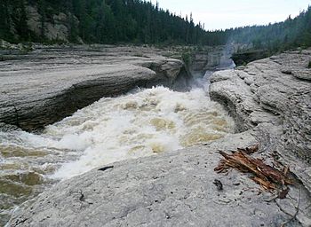
Rapids on Trout River, from Mackenzie Highway
|
|
| Country | Canada |
| Territory | Northwest Territories |
| Physical characteristics | |
| Main source | Sambaa K'e 490 meters (1,610 ft) 60°44′18″N 121°08′51″W / 60.73833°N 121.14756°W |
| River mouth | Mackenzie River 145 meters (476 ft) 61°18′15″N 119°50′40″W / 61.30423°N 119.84453°W |
The Trout River is a river found in the Northwest Territories of Canada. It is an important river that flows into the much larger Mackenzie River. Think of it like a smaller stream joining a big main river.
The River's Journey
The Trout River begins in a lake called Sambaa K'e. This is its starting point, high up at about 490 metres (1,610 ft) above sea level.
From there, the river flows first towards the north and then turns east. Along its path, you might see some rapids, which are fast-moving parts of the river where the water rushes over rocks.
The Trout River also collects water from many smaller creeks and lakes as it travels. Sometimes, the river's path becomes very curvy, like a snake winding its way across the land. This is called being meandered.
The Mackenzie Highway crosses over the river. After this point, the river makes a sharp turn, heading west and then north again.
It then flows through a deep valley, or canyon, which is about 60 metres (200 ft) deep. Finally, the Trout River empties its waters into the mighty Mackenzie River. This meeting point is about 60 kilometres (37 mi) downstream from a place called Jean Marie River. It's also about 95 kilometres (59 mi) upstream from Mills Lake. At this point, the river is about 145 metres (476 ft) above sea level.
 | James Van Der Zee |
 | Alma Thomas |
 | Ellis Wilson |
 | Margaret Taylor-Burroughs |

