Truro Island facts for kids

A closeup map showing Truro Island
|
|
| Geography | |
|---|---|
| Location | Northern Canada |
| Coordinates | 75°17′N 97°11′W / 75.283°N 97.183°W |
| Archipelago | Queen Elizabeth Islands Canadian Arctic Archipelago |
| Area | 21 km2 (8.1 sq mi) |
| Administration | |
|
Canada
|
|
| Territory | Nunavut |
| Region | Qikiqtaaluk |
| Demographics | |
| Population | Uninhabited |
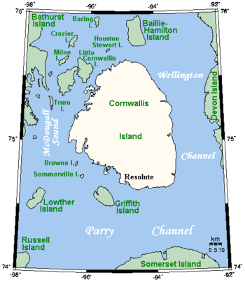
Truro Island is a small, long island located in the far north of Canada. It is part of the Canadian Arctic Archipelago, a group of many islands in the Arctic Ocean. This island sits in a waterway called McDougall Sound, right between two larger islands: Bathurst Island and Cornwallis Island.
Truro Island is found in the Qikiqtaaluk Region of Nunavut, a huge territory known for its icy landscapes. The island is about 21 square kilometers in size. It is not home to any people, meaning it is uninhabited.
Studying the Arctic Environment
Even though Truro Island is small and empty, it has been an important place for science. Scientists have used it as a base camp for special studies. These studies are part of something called the Collaborative Interdisciplinary Cryospheric Experiment, or C-ICE for short.
What is C-ICE?
C-ICE stands for Collaborative Interdisciplinary Cryospheric Experiment.
- Collaborative means many different groups and scientists work together.
- Interdisciplinary means they study many different things at once.
- Cryospheric refers to all the frozen parts of Earth. This includes things like sea ice, glaciers, and snow.
These C-ICE studies help scientists understand how the atmosphere (the air around us), sea ice (frozen ocean water), and the ocean itself interact. They collect data to see how these parts of the Arctic environment affect each other.
C-ICE Studies on Truro Island
Scientists carried out several C-ICE studies from Truro Island. These included:
- C-ICE'2000
- C-ICE'2001
- C-ICE'2002
By studying these interactions, scientists can learn more about how the Arctic is changing. This information is important for understanding global climate patterns.
 | Victor J. Glover |
 | Yvonne Cagle |
 | Jeanette Epps |
 | Bernard A. Harris Jr. |


