
Tseax River Cone facts for kids
Quick facts for kids Tseax Cone |
|
|---|---|

Tseax Cone
|
|
| Highest point | |
| Elevation | 610 |
| Geography | |
| Location | British Columbia, Canada |
| Parent range | Nass Ranges |
| Topo map | NTS 103J/2 |
| Geology | |
| Age of rock | Historical |
| Mountain type | Cinder cone |
| Volcanic arc/belt | Northern Cordilleran Volcanic Province |
| Last eruption | 1690 ± 150 years (18th deadliest eruption of all time) |
| Climbing | |
| Easiest route | drive |
The Tseax River Cone (also known as Aiyansh Volcano) is a type of volcano called a cinder cone. It is found in British Columbia, Canada. A cinder cone is a cone-shaped hill made from volcanic ash and rock pieces that pile up around a volcanic vent. The volcano and the land around it are now part of a special protected area. This area is called the Nisga'a Memorial Lava Beds Provincial Park. A provincial park is a place where nature is kept safe for everyone to enjoy and learn from.
A long time ago, in the 18th century, this volcano had a very big eruption. This natural event caused a lot of damage and sadly affected many people living nearby.
Contents
What is the Tseax River Cone?
The Tseax River Cone is a cinder cone volcano. This means it's a relatively small, steep-sided volcano. It is built from bits of hardened lava, called cinders, that explode out of a single vent. These cinders fall back down around the vent, creating the cone shape. The cone is about 610 meters (2,000 feet) tall. It is part of a larger group of volcanoes in western Canada.
Where is the Tseax River Cone Located?
This volcano is in the Nass Ranges of British Columbia, Canada. It is found in a region known for its volcanic activity. This area is called the Northern Cordilleran Volcanic Province. The volcano is located near the Tseax River, which is how it got its name. The land around it is beautiful and rugged, with forests and mountains.
The Tseax River Eruption
The last time the Tseax River Cone erupted was around the year 1700. This eruption was very powerful. It sent lava flowing down the valleys. The lava flow was hot and moved quickly. It covered a large area of land. The lava destroyed villages and forests in its path. This event was a major natural disaster for the local Nisga'a people. The lava flow created the unique landscape we see today.
Nisga'a Memorial Lava Beds Provincial Park
Today, the area around the Tseax River Cone is protected. It is part of the Nisga'a Memorial Lava Beds Provincial Park. This park was created to protect the lava beds. It also honors the memory of those affected by the eruption. Visitors can see the hardened lava flows. They can also learn about the volcano's history. The park helps people understand the power of nature. It also teaches about the history of the Nisga'a Nation.
Images for kids
-
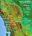
Map of Northern Cordilleran Volcanic Province showing location of Tseax Cone


