Turnagain Island (Queensland) facts for kids
|
Buru Island
|
|
|---|---|

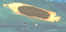
A Landsat image of Turnagain Island
|
|

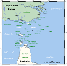
A map of the Torres Strait Islands showing Turnagain in the northern central waters of Torres Strait
|
|
| Geography | |
| Location | Northern Australia |
| Coordinates | 9°34′01″S 142°16′59″E / 9.567°S 142.283°E |
| Archipelago | Torres Strait Islands |
| Adjacent bodies of water | Torres Strait |
| Area | 11.98 km2 (4.63 sq mi) |
| Length | 7.5 km (4.66 mi) |
| Width | 2.2 km (1.37 mi) |
| Administration | |
| State | Queensland |
| Local government area | Torres Strait Island Region |
Turnagain Island, also known as Buru Island, is a beautiful island in the Torres Strait Islands. This group of islands is like a chain, called an archipelago. Turnagain is part of the Western Islands region. It is located in the northern part of the Torres Strait, which is a waterway in Queensland, Australia. The island is managed by the Torres Strait Island Region local government.
Island Location and Shape
Turnagain Island is found about 38 kilometers (about 24 miles) south of Papua New Guinea. It is shaped like a long teardrop. The island stretches about 7.5 kilometers (4.7 miles) in length. It is also up to 2.2 kilometers (1.4 miles) wide.
Nature and Environment
Turnagain Island covers an area of almost 12 square kilometers (4.6 square miles). It is a very green place, covered mostly by thick forests. The island is currently uninhabited, meaning no people live there permanently. This allows its natural environment to thrive. It is a quiet spot, perfect for wildlife.
 | Isaac Myers |
 | D. Hamilton Jackson |
 | A. Philip Randolph |

