
Tynron Doon facts for kids
Tynron Doon is an ancient hill fort located near the village of Tynron in Dumfries and Galloway, Scotland. It's a special place that people lived in for a very long time.
This fort was used on and off starting thousands of years ago, during the Iron Age. Later, around the 1500s, a building shaped like the letter L, called a tower house, was built there. Tynron Doon is found at the southern part of the Scaur hills.
Contents
What is Tynron Doon?
Tynron Doon was originally a large hill fort from the Iron Age. It had many walls and ditches to protect the people living inside. The way it looks today is very similar to how it was built long ago.
A Natural Fortress
The fort sits on a spur hill that is part of Auchengibbert Hill. It reaches about 289 meters (948 feet) high. The very top of the hill is a flat, oval area. It measures about 40 by 45 meters (131 by 148 feet).
The fort was built in a naturally strong spot. It had steep slopes on its north, south, and east sides. This made it very hard for enemies to attack.
Defenses of the Fort
The western side of the fort was not as steep. So, people added extra defenses there. They dug three ditches and built two large earth walls, called ramparts. Some of these ditches were even cut right into the rock!
Life at Tynron Doon
People lived at Tynron Doon for many centuries. It was a safe place to live and watch over the surrounding land.
Medieval Beacon
In the 1400s, Tynron Doon was an important spot for communication. It was one of nine places where beacons were kept. These beacons were fires lit on hilltops to send signals. They were used by the local sheriffs to warn people of danger.
The Tower House
Around the 1500s, a special building was added to the fort. This was an L-shaped tower house. It was built in the northwest corner of the main area. The main part of the building was about 20 by 42 feet (6 by 13 meters).
There was also a smaller part, about 8 by 10 feet (2.4 by 3 meters). Experts think this smaller part might have been a staircase tower.
What Happened to the Tower?
The tower house was likely taken down between 1700 and 1750. Its stones might have been used to build the local church, Tynron Kirk. Around the same time, a strong wall, called a barmkin, might have been built around the top of the hill.
A Shepherd's Hut
Later, in the 1700s or 1800s, a small hut was built on the site. This hut was probably a shepherd's bothy. A bothy is a simple shelter used by shepherds or travelers.
Images for kids
-
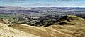
Tynron Doon (on the right) viewed from Auchengibbert Hill. You can see the valley of the River Nith (Nithsdale) and Queensberry Hill on the left. The village of Penpont is in the front, and Thornhill is beyond it.

