Táin Way facts for kids
Quick facts for kids Táin Way |
|
|---|---|

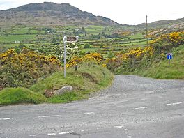
Trail near Slieve Foy (Carlingford Mountain)
|
|
| Length | 40 kilometres (25 miles) |
| Location | County Louth, Ireland |
| Designation | National Waymarked Trail |
| Trailheads | Carlingford |
| Use | Hiking |
| Elevation gain/loss | 1,025 m (3,363 ft) |
| Difficulty | Moderate |
| Season | all |
The Táin Way is an exciting walking trail in County Louth, Ireland. It's a circular path, meaning it starts and ends in the same place: the charming town of Carlingford. This trail is about 40-kilometre (25-mile) long and most people take two days to walk it all. It's known as a National Waymarked Trail, which means it's a special, well-marked route for hikers.
Contents
Discover the Táin Way!
The Táin Way is a famous long-distance walking path. It goes all around the beautiful Cooley Peninsula in County Louth, Ireland. This trail is perfect for hikers and offers amazing views. It's a great way to explore the Irish countryside.
What is a National Waymarked Trail?
A National Waymarked Trail is a special kind of walking route. These trails are officially recognized and marked out for hikers. The Táin Way is managed by several groups. These include the Louth County Council, Coillte (who look after forests), and the Walks Partnership Group. The National Trails Office of the Irish Sports Council also helps oversee these trails. They make sure the paths are safe and fun for everyone.
The Story Behind the Name
The Táin Way gets its name from an ancient Irish legend. This legend is called the Táin Bó Cúailnge. In English, it means "The Cattle Raid of Cooley." Many parts of this famous story happened right here on the Cooley Peninsula. So, as you walk the trail, you're following in the footsteps of ancient heroes! The trail was first thought up by J. B. Malone. It was officially opened on August 21, 1986. Liam Kavanagh, who was a government minister at the time, opened it.
Exploring the Trail
The Táin Way adventure begins in Carlingford. From there, the path climbs up the northern side of Slieve Foy. This is a big mountain in the area. You'll then cross a place called Clermont Pass. This pass is below another spot called Clermont Carn. Eventually, you'll reach the village of Ravensdale.
After Ravensdale, the trail follows a ridge. A ridge is like a long, narrow hilltop. This ridge is between two mountains: Carnawaddy and Castle Mountain. These are part of the Cooley Mountains. Finally, the path goes across the southern slopes of Slieve Foy. This brings you right back to Carlingford, completing the circular journey.
Improving the Trail
In 2010, experts looked at all the National Waymarked Trails. They found that many people used the Táin Way. Some people walked it for a day, and others for several days. They suggested making some changes to the trail. For example, they thought it would be good to add more smaller circular walks off the main trail. They also recommended changing parts of the path that were on paved roads. This would make the trail even more natural and enjoyable for walkers.
 | John T. Biggers |
 | Thomas Blackshear |
 | Mark Bradford |
 | Beverly Buchanan |

