
Unterägeri facts for kids
Quick facts for kids
Unterägeri
|
||
|---|---|---|
 |
||
|
||

Unterägeri
Location in Switzerland

Unterägeri
Location in Canton of Zug
|
||
| Country | Switzerland | |
| Canton | Zug | |
| District | n.a. | |
| Area | ||
| • Total | 25.62 km2 (9.89 sq mi) | |
| Elevation | 727 m (2,385 ft) | |
| Population
(Dec 2020 )
|
||
| • Total | 8,972 | |
| • Density | 350.20/km2 (907.00/sq mi) | |
| Postal code |
6314
|
|
| Surrounded by | Baar, Menzingen, Oberägeri, Sattel (SZ), Steinerberg (SZ), Walchwil, Zug | |

Unterägeri is a town in the canton of Zug in Switzerland. It is a type of local government area called a municipality.
History of Unterägeri
The area of Ägeri was first mentioned way back in 1150. Later, in 1538, it was called Ober Egere.
The very first church in this valley was built in 876. After the year 1100, the land became part of the Einsiedeln monastery. The famous Battle of Morgarten also had an impact on this region.
The municipality of Unterägeri as we know it today started in the 15th century. Around the year 1500, people built several small chapels and the first government building in Oberägeri. In 1669, the community gained the right to choose its own priest.
In 1726, the church was robbed. Later, in 1766, the governments of Oberägeri and Unterägeri had a big disagreement. This led to the two municipalities splitting up in 1798. At that time, Unterägeri was known as Wilägeri.
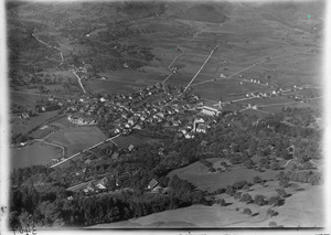
Geography and Location
Unterägeri covers an area of about 25.6 square kilometers (about 9.9 square miles). A large part of this land, about 37%, is used for farming. More than half, about 54%, is covered by forests. Buildings and roads take up about 6.7% of the land. The rest, a small part, is made up of rivers or mountains.
The town is located on the western shore of the beautiful Ägerisee lake. As mentioned, it was once called Wilägeri. It was an outer part of Ägeri. When the Helvetic Republic was formed in 1798, it split into two separate towns: Oberägeri and Unterägeri. There is also a place called Mittenägeri which lies between the two villages. It is part of Unterägeri.
At first, Unterägeri was smaller than Oberägeri. However, it grew much faster during the time of Industrialisation. This was because it was located on the main road from Zug to Schwyz. Because of this, Unterägeri is now much larger than Oberägeri.
People and Community
Unterägeri has a population of about 8,900 people. As of 2007, about 19.7% of the people living here were from other countries. Over the last ten years, the number of people living in Unterägeri has grown by about 15.8%. Most people in the town, about 87.8%, speak German. Serbo-Croatian is the second most common language, and English is the third.
In the 2007 national election, the most popular political party was the SVP. They received 32% of the votes. The next most popular parties were the CVP, the FDP, and the Green Party.
Many adults in Unterägeri have a good education. About 74.1% of people aged 25 to 64 have finished high school or gone on to higher education, like university.
The unemployment rate in Unterägeri is quite low, at 1.63%. This means most people who want to work can find jobs. In 2005, there were 178 people working in farming and related businesses. In the manufacturing and industry sector, 736 people were employed. The largest number of people, 1,587, worked in the service sector, which includes jobs like retail, healthcare, and tourism.
See also
 In Spanish: Unterägeri para niños
