
Valdecañas de Cerrato facts for kids
Quick facts for kids
Valdecañas de Cerrato
|
|
|---|---|
|
Town and district
|
|

Map of el Cerrato. Valdecañas de Cerrato in the centre at 313
|
|
| Country | Spain |
| Comarca | El Cerrato |
| Municipality | Pedanía of Baltanás |
| Elevation | 810 m (2,660 ft) |
| Population
(2012)
|
|
| • Total | 64 |
| INE | |
| Postal code |
34249
|
| Area code(s) | 979 |
Valdecañas de Cerrato is a small town and a district that's part of the Baltanás municipality in Spain. It's about 9 kilometers (5.6 miles) from Baltanás. You can find it in the El Cerrato region, which is in the Palencia province, within the Castile and León area of Spain. It's a place with a long history and interesting old buildings.
Contents
Geography and Climate

Valdecañas de Cerrato is a hilly area surrounded by open fields called moors. The town itself sits at the base of peaks like Piyayo or Roble, also known as "Carrascal hill." Several streams, including Castillo, Pozo, Valle, and Pozuelo, flow through the valley. These streams meet near the cemetery and feed many springs. The water from these springs eventually flows towards the Pisuerga river.
The town is located about 14 kilometers (8.7 miles) from the A-62 highway. It's 37 kilometers (23 miles) from Palencia, 53 kilometers (33 miles) from Burgos, and 68 kilometers (42 miles) from Valladolid. Valdecañas de Cerrato shares borders with many other towns.
The climate here is continental, which means winters are cold and dry. Summers are warm, while spring and autumn are short and pleasant.
Population of Valdecañas de Cerrato
According to official numbers from the Instituto Nacional de Estadística, Valdecañas de Cerrato had 64 residents as of January 1, 2012.
History of the Town
Early History and Fortifications

Valdecañas de Cerrato was likely settled again around the late 800s. At this time, the Counts of Castile wanted to protect the El Cerrato region. Christian armies helped to rebuild the town and built walls to defend it from attacks. From this period, an old burial ground (necropolis) can still be found near the Virgen del Campo hermitage.
In 999, the Alfoz of Palenzuela was created, and Valdecañas de Cerrato became part of it. In 1070, a woman named Doña Domenga gave a monastery and land in the area to San Pedro de Cardeña. In 1074, the town was mentioned as part of the dowry for El Cid's wife, Jimena Díaz. She later sold some of her land in Valdecañas to the Burgos cathedral in 1113.
Medieval Times and Ownership
In the 11th century, Ferdinand I of León and Castile added several monasteries in Valdecañas to San Pedro de Arlanza. By 1352, the town was known as Valdecañas de Suso. It was part of the Merindad in El Cerrato region. The town shared a special tax called martiniegas with Palenzuela. At this time, the town belonged to Gonzalo de Sandoval, a knight who fought with Alfonso XI of Castile.
Later Centuries and Changes
During the time of the Catholic Monarchs (late 1400s), Valdecañas de Cerrato was still part of El Cerrato. In 1475, Queen Isabella ordered a tax on the town. In 1484, Bernardino Perez de Sarmiento, who owned nearby Hornillos de Cerrato, rented out land in Valdecañas to Alfonso Enríquez.
By 1675, the town was owned by the Admiral of Castile. It had five religious buildings, including the church of San Nicolás de Bari and several hermitages. The population was about 50 people. There was also a small hospital. By 1702, some hermitages were in ruins, and the population had dropped to 36 residents.
In 1752, the town was called Baldecanas de Arriva and was part of the province of Valladolid. The population had grown to 66 people living in 86 houses. The town also had a flour mill and beehives. In 1783, a severe illness caused by dirty streams reduced the population from 110 to just 30 residents.
Modern Era and Administration
During the Revolutionary War (1808-1812), the hills around Valdecañas de Cerrato were a hiding place for Spanish fighters. A leader named Juan Puertas used the town's hills to attack French soldiers. The people of Valdecañas helped his group.
In 1828, the town was known as Val de Cañas. It was part of the Tierra de Campos judicial district. In 1842, a dictionary mentioned that it had 43 residents. By 1849, it was part of the Baltanás judicial district.
In the late 20th century, Valdecañas de Cerrato became part of the Baltanás municipality. In 1955, its church became part of the Palencia diocese instead of Burgos. Finally, on February 21, 1974, it officially joined the municipality of Baltanás, where it remains today.
Meaning of the Name
| Century | Name |
|---|---|
| 11th century | Valle Kannas |
| 11th century | Bal de Kannas |
| 11th century | Valdecannas |
| 14th century | Valdecañas de Suso |
| 15th century | Valdecañas de Suso |
| 18th century | Baldecañas de Arriva |
| 19th century | Val de Cañas |
| 19th century | Valdecañas |
| 20th century | Valdecañas de Cerrato |
The town was first called Valle Kannas. Its name comes from the words val (meaning valley) and caña (meaning reed). So, the name means "valley of reeds." Over time, it was also called Baldecañas de Arriva, which referred to its location higher up on a hill. Its current name, Valdecañas de Cerrato, shows that it belongs to the El Cerrato region. The name "Cerrato" comes from the wavy landscape with many hills.

Historical Buildings and Sites


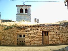
Church of San Nicolás de Bari
This church is located on the highest point in the town center. It is dedicated to San Nicolás de Bari. The building is in the Baroque style and dates back to the 16th century. It has three main sections (naves) and a square tower made of cut stone. The church has been changed several times, with a big renovation in 1780.
Next to the church, there is a medieval burial ground. Inside the church, there used to be a Flemish painting called "Adoration of the Kings." In 2008, the building was fully restored, including its main altar and two side altars. The Virgen del Campo, who is the town's patroness, is kept in a side chapel. On her special day, she is carried in a parade to the hermitage.
The church was once home to six groups or "fraternities."
Virgen del Campo Hermitage
This hermitage is located outside the town, about 500 meters (1,640 feet) to the south. It is dedicated to the Virgen del Campo. It was built in the 17th century and has a Baroque altar. The altar features an image of Mary from the 13th century, in the Gothic style.
Inside, there is also a stone shield above the entrance to a small chapel. This shield belongs to the Tevar family, who supported good works in the area. The chapel has an altar dedicated to the Immaculate Conception and a statue of Christ lying down. Around the chapel, there is an old burial ground from the time the town was resettled, with tombs from the 11th century.
Old Fortified Houses
At the entrance to the town, there is an old religious building that used to be the priest's house. It is now privately owned. On its front, you can see a shield of the Virgen del Carmen dated 1738, with sculptures of San Antonio and Santa Barbara. A sundial can still be seen on one corner. Inside, it has a beautiful ceiling from the 17th century.
Another old religious building is called the Casa del Cordón. It has shields on its front in the plateresque style, showing an umbilical cord and symbols of San Francisco. These symbols suggest that the Franciscan religious order once passed through the town. This building still belongs to the Catholic Church, but it has become old and damaged over time.
There is also a civil building with a coat of arms, now privately owned. It is made of cut stone and has arched windows. People believe it was once a large public building, possibly a hospital or a place for care.
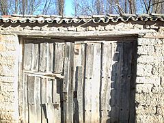
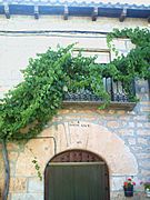
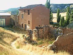
Traditional Architecture
The traditional buildings in Valdecañas de Cerrato are usually one or two stories high with an attic. They are built in a typical Castilian style. The outside walls are mostly made of adobe and a whitish limestone, which is common in the area. The stonework shows that stonemasons from Merindad de Trasmiera (Cantabria) may have influenced the building style. They worked on both religious and civil buildings.
Another interesting type of building is the cellars dug into the ground. These show that wine-making was important in the area. Most of them are on the Piyayo hillside, but some are also found near the church and in other parts of the town.
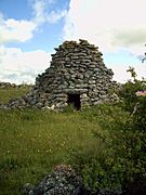
You can also see traditional shepherd huts. These are circular buildings made of stone without any mortar. Their doors face south to protect from the weather. They provided shelter for shepherds.
- Doorway details - 16th century house – Wine cellars - Shepherd Hut - Adobe houses.
-
-
-
-
-

.JPG)


El Castillo (The Castle)

About 4 kilometers (2.5 miles) north of the village, in the valley, are the remains of an old fortification called El Castillo. It sits on an isolated hill and is surrounded by the Ontanilla and Castillo streams. The ruins cover an uneven area, about 90 meters (295 feet) long and 27 meters (89 feet) wide. It is surrounded by a stone wall that is 1.8 meters (6 feet) thick and up to 1.2 meters (4 feet) high. Inside, you can still see parts of a tower, which is about 2.5 meters (8 feet) tall.
Near the castle was a village called Villovayo, which was abandoned in 1516. The Santa Ana hermitage was also in this area. The cut stones used to build these old fortresses are now being used for other buildings, so the walls are exposed to weather and erosion.
Cañada Real Burgalesa

The Cañada Real Burgalesa-Soriana Occidental is a very long path, about 700 kilometers (435 miles) long. It passes through Valdecañas de Cerrato, coming from Tabanera de Cerrato and continuing south to Hornillos de Cerrato. This path was a major route for moving sheep across Spain, a practice called transhumance.
Near this path, there are several ruined buildings. The wild area is called Valdecañuelas, and you can still see the front of an old religious building there. The most common type of sheep in this area was the churra sheep. Their wool was taken to ports in Cantabria and Vizcaya.
See also
 In Spanish: Valdecañas de Cerrato para niños
- List of municipalities in Palencia
- El Cerrato
