
Varennes-sur-Tèche facts for kids
Quick facts for kids
Varennes-sur-Tèche
|
||
|---|---|---|
 |
||
|
||

Varennes-sur-Tèche
Location in France

Varennes-sur-Tèche
Location in Auvergne-Rhône-Alpes
|
||
| Country | France | |
| Region | Auvergne-Rhône-Alpes | |
| Department | Allier | |
| Arrondissement | Vichy | |
| Canton | Jaligny-sur-Besbre | |
| Intercommunality | Le Donjon–Val Libre | |
| Area
1
|
18.73 km2 (7.23 sq mi) | |
| Population
(2007)
|
253 | |
| • Density | 13.508/km2 (34.98/sq mi) | |
| Time zone | UTC+01:00 (CET) | |
| • Summer (DST) | UTC+02:00 (CEST) | |
| INSEE/Postal code |
03299 /03220
|
|
| Elevation | 258–380 m (846–1,247 ft) (avg. 282 m or 925 ft) |
|
| 1 French Land Register data, which excludes lakes, ponds, glaciers > 1 km2 (0.386 sq mi or 247 acres) and river estuaries. | ||

Varennes-sur-Tèche is a small village, also known as a commune, located in the heart of France. It is part of the Allier department.
Contents
Discover Varennes-sur-Tèche
Varennes-sur-Tèche is a quiet place with a small population. In 2007, about 253 people lived there. The village is situated at an average height of 282 meters (about 925 feet) above sea level. Its lowest point is 258 meters, and its highest is 380 meters. The total area of the commune is 18.73 square kilometers (about 7.23 square miles).
Geography and Location
This commune is found in the Allier department, which is in the central part of France. It is part of the Vichy arrondissement and the Jaligny-sur-Besbre canton. These are ways that France organizes its regions for local government.
Local Government
Like all communes in France, Varennes-sur-Tèche has a mayor who helps run the village. From 2008 to 2014, the mayor was Gilles Berrat. The commune also works with other nearby villages in a group called an "intercommunality," which for Varennes-sur-Tèche is "Le Donjon–Val Libre." This helps them share services and resources.
Images for kids
-
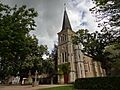
The Saint-Léger Church in Varennes-sur-Tèche.
See also
 In Spanish: Varennes-sur-Tèche para niños
