Vaugondy Island facts for kids

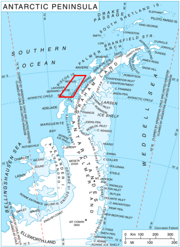
Location of Biscoe Islands in the Antarctic Peninsula region
|
|
|
Location in Antarctica
|
|
| Geography | |
|---|---|
| Location | Antarctica |
| Coordinates | 65°24′37″S 65°21′47″W / 65.41028°S 65.36306°W |
| Archipelago | Biscoe Islands |
| Administration | |
| Administered under the Antarctic Treaty System | |
| Demographics | |
| Population | Uninhabited |
Vaugondy Island (Bulgarian: остров Вогонди, romanized: ostrov Vogondi) is a small island in Antarctica. It is mostly covered in ice and snow. This island is part of the Biscoe Islands group. It is located on the northeast side of Johannessen Harbour.
What is Vaugondy Island?
Vaugondy Island is a landmass that is almost completely covered by ice. It is located in the Pitt Islands group, which is part of the larger Biscoe Islands chain. The island stretches about 1.85 kilometers (1.15 miles) from north to south. It is also about 1.68 kilometers (1.04 miles) wide from east to west.
Who was Vaugondy?
The island is named after a famous French mapmaker. His name was Didier Robert de Vaugondy. He lived from 1723 to 1786. Didier Robert de Vaugondy created many maps during his lifetime. In 1777, he published an important map. This map showed the south polar region. Naming the island after him honors his work in geography.
Where is Vaugondy Island Located?
Vaugondy Island is found in a specific part of the Biscoe Islands. It is located 2.78 kilometers (1.73 miles) west-southwest of Trundle Island. It is also 1.1 kilometers (0.68 miles) northwest of Jingle Island. To its east, it is 2.08 kilometers (1.29 miles) from Animas Island. Finally, it lies 3.4 kilometers (2.1 miles) south of Ribnik Island. British explorers mapped this area in 1971.


