
Victoria, Hong Kong facts for kids
Quick facts for kids
City of Victoria
維多利亞市
Victoria
|
|
|---|---|
|
City
|
|

Praya Central of the City of Victoria, 1870s
|
|
_(cropped).png)
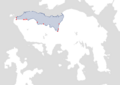
Current day boundary of Victoria City (2023)
|
|
| Dependent territory | |
| Country | United Kingdom |
| Founded as a town | 25 January 1841 |
| Incorporated as a city | 11 May 1849 |
| Founded by | British Hong Kong, Charles Elliot |
| Elevation | 552 m (1,811 ft) |
| Time zone | UTC+08:00 (HKT) |
| City of Victoria | |||||||||||||||
|---|---|---|---|---|---|---|---|---|---|---|---|---|---|---|---|
| Traditional Chinese | 維多利亞市 維多利亞城 |
||||||||||||||
| Simplified Chinese | 维多利亚市 维多利亚城 |
||||||||||||||
| Cantonese Yale | Wàih dō leih a shíh Wàih dō leih a shìhng |
||||||||||||||
|
|||||||||||||||
The City of Victoria (also called Victoria City or simply Victoria) was the main city and unofficial capital of Hong Kong when it was a British territory. It was first called Queenstown but soon became known as Victoria. This city was one of the first big settlements in Hong Kong. Its borders are even written down in the laws of Hong Kong. Many important government offices are still located within its old boundaries today.
Today, the area known as Central is at the heart of Victoria City. The city grew to include many areas we know today, like Kennedy Town, Shek Tong Tsui, Sai Ying Pun, Sheung Wan, Wan Chai, and parts of Causeway Bay. Even though the name "Victoria" isn't used as much for the whole area, you can still find it in names like Victoria Park, Victoria Peak, and Victoria Harbour. It's also used by groups like the Victoria City District of the Hong Kong Scout.
Contents
History of Victoria City
The name "City of Victoria" first appeared in official records around 1845. It officially became a city on May 11, 1849.
In 1857, the British government made Victoria City bigger. They divided it into four main areas called wans (Chinese: 環; Jyutping: waan4; literally "rings", meaning 'rings' or 'circles'). These areas were:
- Sai Wan (meaning 'West Ring', which includes Kennedy Town, Shek Tong Tsui, and Sai Ying Pun today)
- Sheung Wan (meaning 'Upper Ring', which is Sheung Wan today)
- Choong Wan or Chung Wan (meaning 'Central Ring', which is Central today)
- Ha Wan (meaning 'Lower Ring', which is Wan Chai today).
The first three names, "Sai Wan", "Sheung Wan", and "Choong Wan", are still used in Chinese today. These four wans were then divided into nine smaller areas called yeuks (Chinese: 約, similar to 'districts' or 'neighbourhoods'). The city also included parts of East Point and Happy Valley.
Around 1903, special stones were placed to mark the city's boundaries. Six of these original boundary stones can still be seen today. They stretch from Causeway Bay all the way to Kennedy Town.
By the 1890s, Victoria stretched about four miles along the coast from west to east. Buildings were often made of strong granite and brick. Buses and the new tramway became the main ways people got around the city.
The city was named after Queen Victoria in 1843. Its main part was in what is now Central. It covered many areas on Hong Kong Island, including Admiralty, Sheung Wan, Wan Chai, East Point, Shek Tong Tsui, the Mid-levels, the Peak, Happy Valley, Tin Hau, and Kennedy Town.


First Streets in Victoria
When Victoria City was first planned, 16 streets were given names on the 1845 map. Most of these streets are in the areas of Central and the Mid-Levels, with two in Sheung Wan. The second Governor of Hong Kong, Sir John Francis Davis, officially named these streets. All 16 streets were named after important people from Great Britain or Hong Kong. Their location and layout were chosen based on how important the person was.
Here are a few examples of these first streets:
| Street Name | Location | Person Named After | Their Important Role |
|---|---|---|---|
| Queen's Road | Central | Queen Victoria | The Queen of Great Britain |
| Caine Road | Mid-Levels | William Caine | Colonial Secretary of Hong Kong |
| Pottinger Street | Central | Sir Henry Pottinger | First Governor of Hong Kong |
| Wellington Street | Central and Sheung Wan | Arthur Wellesley, 1st Duke of Wellington | A famous military leader and Prime Minister |
Boundary Stones

In 1903, the Hong Kong Government put up several special stones to show where Victoria City ended. These stones are about 98 cm tall and have "City Boundary 1903" carved into them. They served as clear physical markers for the city's official limits.
In 2021, three more of these old boundary stones were found. This means there are now 10 known stones, though one disappeared in 2007.
Here are some of the known boundary stones:
| No. | Image | Location | Region | Notes |
|---|---|---|---|---|
| 1 |  |
Sai Ning Street | Kennedy Town | Moved a few meters from its original spot in the 1970s. |
| 2 |  |
Slope of Mount Davis, south of Victoria Road | Mount Davis | Found on December 12, 2021. |
| 3 |  |
Pokfulam Road, near Smithfield | Sandy Bay Gap | |
| 4 |  |
Slope of Lung Fu Shan, near Hatton Road | Lung Fu Shan | Found on December 5, 2021. |
| 5 |  |
Hatton Road, near Kotewall Road | ||
| 6 |  |
Old Peak Road, near Tregunter Path | Mid-Levels | |
| 7 |  |
Magazine Gap Road | Removed in June 2007, its current location is unknown. | |
| 8 |  |
Bowen Road, near Stubbs Road | ||
| 9 |  |
Slope near Rosaryhill School, Stubbs Road | Found on December 12, 2021. | |
| 10 |  |
Wong Nai Chung Road | Happy Valley |
Districts of Victoria City


By 1866, Victoria City was divided into nine districts, also called yeuks. These included:
- Shek Tong Tsui
- Sai Ying Pun
- Taipingshan, a neighborhood near Sheung Wan
- Sheong Wan
- Choong Wan North and South (known as Central today)
- Ha Wan, which is today's Admiralty and Wan Chai
- Wan Chai
- Bowrington, located between today's Wan Chai and Causeway Bay
- So Kun Poo.
Other places that were also considered part of the city's areas included:
- Kennedy Town
- Happy Valley
- Causeway Bay
Images for kids
-
Map of Victoria City with location of boundary rocks marked in red
_(cropped)_edited.png)
See also
 In Spanish: Victoria (Hong Kong) para niños
