Vila Pouca de Aguiar facts for kids
Quick facts for kids
Vila Pouca de Aguiar
|
|||
|---|---|---|---|
|
Municipality
|
|||
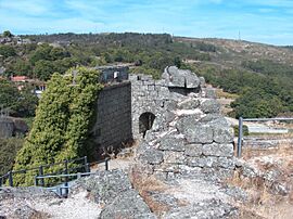
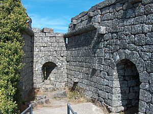
The ruins of the Castle of Pena de Aguiar
|
|||
|
|||
 |
|||
| Country | |||
| Region | Norte | ||
| Intermunic. comm. | Alto Tâmega | ||
| District | Vila Real | ||
| Parishes | 14 | ||
| Area | |||
| • Total | 437.07 km2 (168.75 sq mi) | ||
| Elevation | 797 m (2,615 ft) | ||
| Population
(2011)
|
|||
| • Total | 13,187 | ||
| • Density | 30.1714/km2 (78.143/sq mi) | ||
| Time zone | WET/WEST (UTC+0/+1) | ||
| Postal code |
5450
|
||
| Area code | 259 | ||
| Patron | Divino Salvador | ||
| Website | http://www.cm-vpaguiar.pt | ||
Vila Pouca de Aguiar (Portuguese pronunciation: [ˈvilɐ ˈpokɐ ðɨ ɐɣiˈaɾ]) is a town in northern Portugal. It is part of the Vila Real area. In 2011, about 13,187 people lived here. The town covers an area of 437.07 square kilometers.
Contents
A Look at History
Historians have different ideas about how Vila Pouca de Aguiar started. Some think it was built on an old city called Cauca. This city was once ruled by Emperor Theodosius I. But no one knows why its name might have changed.
Another idea is that "Vila Pouca" meant a small farming village. "Aguiar" might have been an old administrative area. This helped people tell it apart from other "Vila Pouca" places. The name "Aguiar" comes from a word meaning "where the eagles are."
In the 1200s, this area was known as the land of Aguiar. It had seven church parishes. One of these was São Salvador de Jugal. This parish is where Vila Pouca de Aguiar is today. Old records from King Afonso II show that São Salvador de Jugal included several small towns.
No one knows exactly when or why the name changed from São Salvador de Jugal to Vila Pouca. This change likely happened in the 1300s.
In the early 1900s, a very important person was Martiniano José Ferreira Botelho. He was a doctor, a pharmacist, and a politician. People knew him for being kind and helping others. He also promoted the local healing waters for treatments. He and his family gave land to the community. This land is now used for the market square, the town's slaughterhouse, and a well.
Exploring the Geography
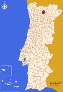
Vila Pouca de Aguiar is in the Alto Tâmega region. It is in the northern part of the Vila Real district. The town sits between the Serra do Alvão and Serra da Padrela mountains. It covers about 437 square kilometers.
This area is a key connection point. It links other towns in Portugal's interior. It also serves as a path to the coast. You can travel there using the A7 and A24 motorways. The town is in a long, fertile valley. High pasture-lands surround it, making it a safe place.
The region has many national monuments and old buildings. These include the Castle of Aguiar da Pena. There's also the ancient Roman mining area of Tresminas. You can find the hot springs of Pedras Salgadas here too. Other interesting places are the Falperra Dam, Dolmens of Alvão, old churches, and medieval bridges.
The town is in a narrow valley. It is about 25 kilometers north of Vila Real, the district capital. The national N2 highway connects them.
In 2006, the A7 toll road to Guimarães was finished. In 2007, the last part of the A24 opened. This road connects Vila Pouca with Vila Real. It is a four-lane highway with no tolls. It links Coimbra to the Spanish border. One of Europe's longest and highest highway bridges is just south of Vila Pouca. It crosses the fertile valley.
Local Communities
The municipality is divided into 14 smaller areas called civil parishes (freguesias). These are:
- Alfarela de Jales
- Alvão
- Bornes de Aguiar
- Bragado
- Capeludos
- Pensalvos e Parada de Monteiros
- Sabroso de Aguiar
- Soutelo de Aguiar
- Telões
- Tresminas
- Valoura
- Vila Pouca de Aguiar
- Vreia de Bornes
- Vreia de Jales
For many years, people have been moving away from this part of Portugal. Most people live in the main town or nearby parishes. Some parishes like Bragado and Pensalves have seen fewer people. But the main town and Sabroso de Aguiar continue to grow.
Weather and Climate
| Climate data for Santa Marta da Montanha, altitude: 866 m (2,841 ft) | |||||||||||||
|---|---|---|---|---|---|---|---|---|---|---|---|---|---|
| Month | Jan | Feb | Mar | Apr | May | Jun | Jul | Aug | Sep | Oct | Nov | Dec | Year |
| Average precipitation mm (inches) | 250 (9.8) |
222 (8.7) |
188 (7.4) |
141 (5.6) |
140 (5.5) |
80 (3.1) |
30 (1.2) |
34 (1.3) |
88 (3.5) |
172 (6.8) |
217 (8.5) |
237 (9.3) |
1,799 (70.7) |
| Source: Portuguese Environment Agency | |||||||||||||
Sister Cities
Vila Pouca de Aguiar has a special friendship with another town. This is called "town twinning."
 Fabero del Bierzo, El Bierzo, Province of León, Spain
Understanding the Economy
Vila Pouca de Aguiar has rich soil and a cool climate. Farming is a main activity here. Farmers grow cereals, potatoes, and vegetables. They also have some vineyards. Small valleys support cattle, which graze in open fields. The Alvão Dam helps irrigate the lands in the Alvão valley. This has been helpful since the mid-1900s.
The economy also includes small service businesses. Many jobs are in government services. There is also a granite mining industry in Jales. The mineral water springs in Pedras Salgadas are important too. Pedras Salgadas is a small spa town. It is about ten kilometers north on the main highway to Chaves.
Exploring Architecture
Ancient Structures
- Dolmen of Serra do Alvão (Portuguese: Anta da Serra do Alvão): This is a group of ancient burial sites. It includes dolmens and menhirs. You can find it in the civil parish of Soutelo de Aguiar.
Military Buildings
- Castle of Pena de Aguiar (Portuguese: Castelo de Pena de Aguiar/Castelo de Aguiar de Pena): This Romanesque castle is made of rock. It has three main parts, including a tower. It is surrounded by circular walls. It is located in the civil parish of Telões.
Famous People from Vila Pouca de Aguiar
- Manuel Gregório de Sousa Pereira de Sampaio (1766-1844): He was a Portuguese military leader and a noble. He was a general for the Miguelists.
- Martiniano José Ferreira Botelho (around 1853 – around 1939): He was a doctor, pharmacist, politician, and a kind person. He was known for helping his community. He also wrote about the healing uses of local waters. His home, called the Casa do Condado (English: House of the County), is a famous spot in town.
- Rui Sampaio (born 1987): He is a Portuguese defensive midfield footballer. He has played in about 250 club games.
 | Aaron Henry |
 | T. R. M. Howard |
 | Jesse Jackson |


