Viola, New York facts for kids
Quick facts for kids
Viola, New York
|
|
|---|---|

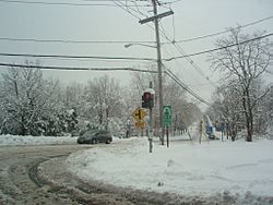
Winter In Viola
|
|

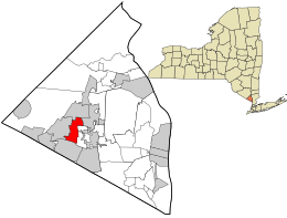
Location in Rockland County and the state of New York.
|
|
| Country | United States |
| State | New York |
| County | Rockland |
| Area | |
| • Total | 2.76 sq mi (7.16 km2) |
| • Land | 2.76 sq mi (7.16 km2) |
| • Water | 0.00 sq mi (0.00 km2) |
| Elevation | 568 ft (173 m) |
| Population
(2020)
|
|
| • Total | 8,208 |
| • Density | 2,969.61/sq mi (1,146.48/km2) |
| Time zone | UTC-5 (Eastern (EST)) |
| • Summer (DST) | UTC-4 (EDT) |
| FIPS code | 36-77574 |
| GNIS feature ID | 0968565 |
Viola is a small community in Rockland County, New York. It is known as a hamlet and a census-designated place. This means it is a local area with a name, but it is not officially a city or town.
Viola is located in the town of Ramapo. You can find it north of Airmont, east of Montebello, south of Wesley Hills, and west of Hillcrest. In 2020, about 8,208 people lived there.
Contents
History of Viola
The Old Alms House
Long ago, in 1837, a place called the Alms House was built in Viola. Back then, Viola was known as Mechanicsville. The Alms House was a home for people who were poor or had no place to live. It was like a shelter where they could get help.
The county bought a 47-acre farm for this purpose. They built a wooden house for the people to live in. Those who lived there helped by working on the farm. Later, in 1883, a brick building was constructed. There was even a school for the children living at the Alms House.
From Alms House to College Campus
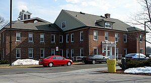
In 1957, the Alms House moved to a new location. The land it used to be on became the site for Rockland Community College. The old brick Alms House building is still there today. It is now used as an administration building for the college, called Daniel T. Brucker Hall.
The farm fields where people once worked are now part of the college campus. There are also two old cemeteries on the campus. One is the Poor Cemetery, also known as Potter's Field. The other is the Gary Onderdonk Veterans' Cemetery.
Geography of Viola
Viola is located at coordinates 41 degrees, 7 minutes, 35 seconds North and 74 degrees, 5 minutes, 0 seconds West. This helps pinpoint its exact spot on a map.
The United States Census Bureau says that Viola covers about 2.7 square miles (7.16 square kilometers). All of this area is land, with no large bodies of water inside its borders.
People of Viola
| Historical population | |||
|---|---|---|---|
| Census | Pop. | %± | |
| 2020 | 8,208 | — | |
| U.S. Decennial Census | |||
In 2000, about 5,931 people lived in Viola. There were 1,681 households, which means 1,681 homes where people lived. Most of the people living in Viola were White. A small number of people were African American, Native American, or Asian. About 2.61% of the population was Hispanic or Latino.
Many households in Viola had children under 18 living with them. About 68.7% of homes were married couples living together. The average household had about 3.53 people.
The population of Viola is quite young. About 39.9% of the people were under 18 years old in 2000. The average age of people in Viola was 28 years.
Education in Viola
Students in Viola attend schools in two different school districts. These are the East Ramapo Central School District and the Suffern Central School District. These districts help make sure children in Viola get a good education.
See also
 In Spanish: Viola (Nueva York) para niños


