
Ramapo, New York facts for kids
Quick facts for kids
Ramapo, New York
|
||
|---|---|---|

Downtown Suffern, a village in Ramapo
|
||
|
||

Location in Rockland County and the state of New York.
|
||
| Country | United States | |
| State | New York | |
| County | Rockland | |
| Area | ||
| • Total | 61.84 sq mi (160.16 km2) | |
| • Land | 61.14 sq mi (158.35 km2) | |
| • Water | 0.70 sq mi (1.80 km2) | |
| Elevation | 371 ft (113 m) | |
| Population
(2020)
|
||
| • Total | 148,919 | |
| • Density | 2,408.13/sq mi (929.81/km2) | |
| Time zone | UTC-5 (Eastern (EST)) | |
| • Summer (DST) | UTC-4 (EDT) | |
| ZIP code |
10901, 10952, 10977, 10970, 10965, 10974
|
|
| Area code | 845 | |
| FIPS code | 36-60510 | |
| GNIS ID | 0979406 | |

Ramapo is a town located in Rockland County, New York, United States. It was first created in 1791 as New Hampstead. The name changed to Ramapo in 1828. The town is named after the Ramapo River.
In 2020, Ramapo had a population of 148,919 people. This makes it the most populated town in New York State, except for those on Long Island. If all towns in New York were cities, Ramapo would be the 12th largest city in the state.
The name "Ramapo" comes from the Lenape people. It means "sweet water" or "slanting rocks." Old maps show the name as Ramepog (1695), Ramepogh (1711), and Ramapog (1775).
The town is located south of Haverstraw. It is west of Clarkstown and Orangetown.
Contents
Ramapo's Past: A Look at History
The land where Ramapo is today was first home to the Munsee people. They were a group within the Lenape nation. Their descendants now live in Mahwah, New Jersey. They are known as the Ramapo Lenape Nation.
During the American Revolutionary War, George Washington visited the area. He is said to have climbed the Ramapo Torne mountain. From there, he watched the British fleet in July 1777. General Washington and his soldiers also set up camp in Suffern. This was a good spot because it was near a mountain pass. Two French soldiers, Rochambeau and Lafayette, were also at this camp. This area was on the way to Yorktown, Virginia. The final battle of the American Revolution happened there.
The Town of New Hampstead was formed in 1791. This was eight years after the Revolutionary War ended. Its name changed to Hempstead in 1797. Then, in 1828, it became Ramapo.
The first railroad line in Rockland County was built in 1841. It went from Piermont to Ramapo. By 1851, the line reached Lake Erie. People thought it was an amazing engineering achievement.
The Ramapo Iron Works was an important factory in the 1800s. It was located near what is now New York State Route 17. They made the first cut nails in America. They also produced wood screws, cotton cloth, and spring steel. The founder, Jeremiah H. Pierson, helped build roads and railroads. A cotton mill building from that time is still standing.
In 1916, New York State Route 59 was extended. It connected Nyack to Spring Valley, Suffern, and Hillburn.
In 2006, Money magazine named Ramapo a great place to live. It was ranked 49th in the U.S. and the best in New York State. The town scored high for its arts, businesses, housing, low crime, and open spaces. It was especially praised for its parks and green areas.
Ramapo's Geography and Natural Features

Ramapo covers about 61.9 square miles (160 km2). Most of this area is land, with a small part being water.
The southern border of the town is the state line with New Jersey. The western border is with Orange County. The Ramapo Mountains have a break at Suffern. This break was formed by the Ramapo River. Because of this, major roads like the New York State Thruway, I-287, and New York State Route 17 pass through the town. A railroad line also runs through here. The Palisades Interstate Parkway goes through the northeastern part of Ramapo.
Torne Mountain is in Harriman State Park. It is about 1,130 ft or 340 m high. This mountain overlooks the Ramapo Pass. You can still see parts of the old Ramapo Iron Works there. During the American Revolution, Torne Mountain was used as a lookout. Soldiers watched for British ships on the Hudson River. There's a legend that George Washington lost his watch on the mountain. Some say you can still hear it ticking in a rock crevice!
The highest point in Ramapo is Squirrel Swamp Mountain. It is near the northern border of the town. Its elevation is about 1,252 feet (382 m).
Communities in Ramapo
Ramapo has several villages and hamlets. These include:
- The hamlet of Antrim
- The village of Airmont
- The village of Chestnut Ridge
- The village of Hillburn
- The hamlet of Hillcrest
- The village of Kaser
- The hamlet of Monsey
- The village of New Hempstead
- The village of New Square
- The village of Montebello
- The hamlet of Ramapo (sometimes confused with the town)
- The hamlet of Sandyfield
- The village of Sloatsburg
- The village of Spring Valley
- The hamlet of Sterlington
- The village of Suffern
- The hamlet of Suffern Park
- The hamlet of Tallman
- The hamlet of Viola
- The village of Wesley Hills
Ramapo's Population: Demographics
| Historical population | |||
|---|---|---|---|
| Census | Pop. | %± | |
| 1820 | 2,072 | — | |
| 1830 | 2,837 | 36.9% | |
| 1840 | 3,222 | 13.6% | |
| 1850 | 3,197 | −0.8% | |
| 1860 | 3,435 | 7.4% | |
| 1870 | 4,649 | 35.3% | |
| 1880 | 4,954 | 6.6% | |
| 1890 | 5,910 | 19.3% | |
| 1900 | 7,502 | 26.9% | |
| 1910 | 11,537 | 53.8% | |
| 1920 | 11,709 | 1.5% | |
| 1930 | 16,321 | 39.4% | |
| 1940 | 18,007 | 10.3% | |
| 1950 | 20,584 | 14.3% | |
| 1960 | 35,064 | 70.3% | |
| 1970 | 76,702 | 118.7% | |
| 1980 | 89,060 | 16.1% | |
| 1990 | 93,861 | 5.4% | |
| 2000 | 108,905 | 16.0% | |
| 2010 | 126,595 | 16.2% | |
| 2020 | 148,919 | 17.6% | |
| 2023 (est.) | 152,843 | 20.7% | |
| U.S. Decennial Census | |||
In 2000, Ramapo had 108,905 people. There were 31,561 households and 24,870 families. The population density was about 1,778.2 inhabitants per square mile (686.6/km2).
About 42.3% of households had children under 18. Most households (64.3%) were married couples. The average household had 3.37 people. The average family had 3.82 people.
The population was quite young. About 33.6% were under 18 years old. The median age was 32 years. For every 100 females, there were 97.4 males.
The median income for a household was $60,352. For a family, it was $67,004. About 16.3% of the population lived below the poverty line. This included 24.3% of those under 18.
By the 2020 Census, Ramapo's population grew to 148,919 people.
Important Places: Ramapo Landmarks

The New Hope Church is a historic Reformed Christian church in Monsey. It was founded in 1824. The church still holds services in its building, which was built in 1869.
In 1887, the Ryan family bought the old Groesbeck mansion. This mansion was built in the 1860s. The estate was called "Montebello." This name was later given to the village where it is located. It is now across from Suffern Middle School.
Torne Brook Farm is another important landmark. It is listed on the National Register of Historic Places.
Fun and Games: Recreation in Ramapo
The Joseph T. St. Lawrence Community, Health, and Sports Complex is a great place for activities. It opened in 2006. The facility has a turf field for sports like football and soccer. It also has an indoor dome for practice. Inside, there are three multi-purpose courts. There's also a running track, gym equipment, and two racquetball courts. You can also find a computer room and a dance studio.
The Ramapo Amateur Basketball Association (RABA) offers basketball leagues. There are leagues for youth aged 7–15. There are also adult leagues for those 18 and older. The Joseph T. St. Lawrence Center also hosts adult racquetball leagues.
The New York Boulders are a professional baseball team. They play near the village of Pomona. They are part of the Frontier League.
Learning in Ramapo: Education
Colleges and Higher Education
Rockland Community College is a public two-year college. It is part of SUNY. The college is located in Viola.
The Sunbridge Institute is in Chestnut Ridge. It is a Waldorf-based learning center. It trains teachers and offers Masters degrees in education.
Public Schools in Ramapo

The town of Ramapo is served by two main school districts. The western part of the town is mostly served by the Suffern Central School District. The eastern part is served by the East Ramapo Central School District.
Suffern Central School District
The Suffern Central School District serves the western half of Ramapo. Until 2017, it was called Ramapo Central. The name was changed to avoid confusion with the East Ramapo district.
This district has five elementary schools for grades K-5:
- Cherry Lane
- Montebello
- R.P. Connor
- Sloatsburg
- Viola
It has one middle school for grades 6–8:
- Suffern Middle School
And one high school:
- Suffern High School
Both the middle and high schools use the mountain lion as their mascot. Cherry Lane Elementary received a National Blue Ribbon School of Excellence award in 2013. Several schools in the district have also received the New York State High Performing Reward School award.
East Ramapo Central School District
The East Ramapo Central School District serves the eastern half of Ramapo. In 2022, this district's public schools taught about 9,500 children. However, about 30,000 children in the district attend private schools. Many of these are yeshivas for the growing Orthodox and Hasidic Jewish community.
The district operates four elementary schools for grades 1–3:
- Grandview
- Summit Park
- Fleetwood
- Margetts
And five elementary schools for grades 4–6:
- Lime Kiln
- Kakiat
- Hempstead
- Eldorado
- Elmwood
It also has two middle schools for grades 7–8:
- Pomona
- Chestnut Ridge
And two high schools:
- Ramapo High School (mascot: griffin)
- Spring Valley High School (mascot: tiger)
In 2005, the Orthodox Jewish community gained control of the school board. This new board started to reduce the budget and lower taxes. This caused disagreements with communities using the public schools. The district has faced financial challenges.
Private Schools in Ramapo
Many private schools in Ramapo are Orthodox Jewish and Hasidic Jewish yeshivas. This is because almost half of the town's population is Jewish. Most of these schools are in the eastern part of town. Examples include Yeshiva Avnei Shlomo and Yeshiva Ohr Reuven.
St. Joseph's School is the only Roman Catholic private school in town. Some Catholic students also attend Don Bosco Preparatory High School in Ramsey, New Jersey.
There are also non-religious private schools. These include the Goddard School, the Skill Building Center, the Green Meadow Waldorf School, and the Rockland County Learning Center.
Connecting Cultures: Sister Cities
Ramapo has a "twinning" program. This program connects Ramapo with towns in other countries. It helps people learn about different cultures. Volunteers and committees raise money for this program. They organize trips for local high school students to visit these twin towns. This gives students a chance to experience life in other countries.
Ramapo currently has seven active twinning committees:
- African Twinning Committee (Ghana)
- Chinese Twinning Committee (China)
- Indian Twinning Committee (India)
- Irish Twinning Committee (Doneraile, Ireland)
- Israeli Twinning Committee (Beit Shemesh, Israel)
- Italian Twinning Committee (Andretta, Italy)
- Philippine-American Twinning Committee (Makati, the Philippines)
Images for kids
-
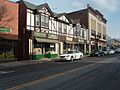
Downtown Suffern, a village in Ramapo
-
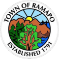
Ramapo, NY Seal
-
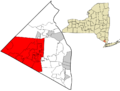
Location in Rockland County and the state of New York.
-
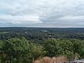
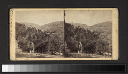
View of Ramapo from mountain
-

Ruins of the Old Furnace on the Ramapao, where the chain was made, that spanned the Hudson River at West Point during the Revolution
-
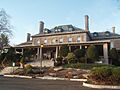
Ryan Mansion in Montebello
-
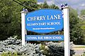
Cherry Lane Elementary School, located in the Village of Airmont. Cherry Lane is one of five elementary schools that help comprise Ramapo (Suffern) Central School District.
See also
 In Spanish: Ramapo para niños
