
History of Rockland County, New York (1798–1900) facts for kids
The recorded history of Rockland County, New York, began on February 23, 1798. This is when the county officially separated from Orange County, New York to become its own area within New York State. Rockland County is about 6 miles (9.7 km) north-northwest of New York City and is part of the larger New York Metropolitan Area. The main government center, called the county seat, is in a small community called New City. The name "Rockland" comes from "rocky land," which is how early settlers described the area. It is New York's southernmost county west of the Hudson River. Rockland County is mostly suburban, with many beautiful parks. It doesn't touch any of New York City's boroughs, but it's only about 9.5 miles (15.3 km) north of Manhattan at its closest point.
Most of the first European settlers were Dutch, along with some Huguenot and Quaker families. These settlers mostly lived off the land. They grew berries, fruits, and vegetables. They also enjoyed hunting, fishing, and trapping.
Early attempts by the Dutch to settle the county were not very successful. In 1664, they gave the land to the English. However, the Dutch left their mark in many place names like Dunderberg Mountain, Sparkill, and High Tor. They also built unique sandstone houses. One example is the 1700 DeWint House in Tappan, which still stands today. It even served as George Washington’s headquarters during the war.
During the American Revolutionary War, Rockland County was a very important place. It was a strategic crossroads, a camping ground for soldiers, and a vital link between the northern and southern colonies. Troops often used ferries at Stony Point (called Kings Ferry) and at Snedens Landing in Palisades (called Dobbs Ferry). The first post office in Rockland County opened in New Antrim, now Suffern, on October 4, 1797.
By 1800, Rockland County had a population of almost 6,400 people. The land was cleared, and homes, schools, and churches were built. Sawmills and gristmills (for grinding grain) were set up along the many creeks. By 1828, most Native Americans had left the county. Slavery also became much less common.
Contents
History of Rockland County


The land that became Rockland County was first home to Algonquian-speaking Native Americans. These included the Munsees, also known as the Lenni Lenape. The Tappan tribe was especially important in this area. Their land stretched from today's Nyack south to Sparkill and Tappan. It also went down the Hackensack River valley into what is now Bergen County, NJ, and along the Palisades cliffs to Edgewater, NJ.
In 1609, Henry Hudson was the first major Dutch explorer to arrive. Hudson thought he had found the famous "Northwest Passage" (a sea route to Asia). He sailed his ship, the Half Moon, up the river that would later be named after him. He passed through the area now known as Haverstraw before going north towards Albany.
Before 1664, when the area was a Dutch colony called New Netherland, there were no formal European settlements in present-day Rockland. However, some individuals explored the area. They bought land from the Tappan tribe, thinking it might be useful later. For example, in 1640, Dutch Captain David Pietersz. de Vries bought the area where the Sparkill Creek flows into the Hudson River.
In 1664, the British Crown took control of New Netherland from the Dutch. In June 1664, the Berkeley-Carteret land grant created the colony of New Jersey. This separated present-day Rockland and Bergen Counties into different political areas. The northern border of New Jersey was a straight line from the Delaware River at Port Jervis to the Hudson River. This line was set at 41 degrees North latitude, where the Palisades Cliffs end near Sneden's Landing in Orangetown. This state line is still there today, even though there were some arguments about the exact border over the years.
In the 1670s, permanent Dutch settlers began to arrive with land grants. They started in the Tappan area. These settlers wanted to escape "city life" and moved from Manhattan to Rockland. Many unique, Dutch-style red sandstone houses still stand today. Also, many place names in the county show their Dutch origins.
In 1683, the Duke of York (who later became King James II of England) created the first twelve counties of New York. At that time, present-day Rockland County was part of Orange County. It was known as "Orange County South of the Mountains." Orangetown was also created then under a royal grant. It originally covered all of modern Rockland County. Around this time, as the English began to settle Nyack and Tappan, the Native Americans started to leave Rockland. They looked for undisturbed land further north.
The Ramapo Mountains created a natural barrier, and the county was very large. This made it hard to manage government activities. At one point, two governments were active, one on each side of the Ramapo Mountains. Because of this, Rockland separated from Orange in 1798 to form its own county. That same year, the county seat moved from Tappan to New City, where a new courthouse was built.
Haverstraw was separated from Orangetown in 1719 and became a town in 1788. It included the areas of present-day Clarkstown, Ramapo, and Stony Point. Clarkstown and Ramapo became towns in 1791, and Stony Point followed in 1865.


During the American Revolution, the British believed controlling the Hudson River was key to winning the war. Rockland saw small skirmishes in Haverstraw, Nyack, and Piermont. There were also important military battles, like the Battle of Stony Point, where General "Mad" Anthony Wayne earned his nickname. George Washington had his headquarters for a time at John Suffern's tavern, which is now the village of Suffern. British Major John André met with American traitor Benedict Arnold near Stony Point. They met to buy plans for the fortifications at West Point. André was captured with the plans in Tarrytown on his way back to the British lines. He was brought to Tappan for trial in the Tappan church, found guilty, hanged, and buried nearby. Another important moment in the Revolution happened on May 5, 1783. General Washington met Sir Guy Carleton at the DeWint House to discuss peace treaty terms. Two days later, Washington visited Sir Guy on a British warship. On this day, the king's navy fired its first salute to the flag of the United States of America.
In the years after the Revolution, Rockland became known for its stone and bricks. Many buildings in New York City were built with bricks made in Rockland. However, making these products required quarrying land that many later thought should be protected as a preserve. Many attempts were made to turn much of the Hudson Highlands in the northern part of the county into a forest preserve, but these efforts were not successful. Union Pacific Railroad president E. H. Harriman helped a lot. He donated land and large amounts of money to buy properties in the Bear Mountain area. Bear Mountain/Harriman State Park became a reality in 1910 when Harriman's widow donated his lands to the state. By 1914, more than a million people visited the park each year. After World War I, Rockland County became a major center for making sausage in New York.
Rockland remained mostly rural until the 1950s. That's when the Palisades Interstate Parkway, Tappan Zee Bridge, and other big roads were built. In the following decades, the county grew into a developed suburb of New York City. As people moved from the five boroughs (especially the Bronx in the early years), the population grew a lot. It went from 89,276 in 1950 to 338,329 in 2020, which is a 379% increase!
Historical Settlements in Rockland County
In the 1800s, many settlements were created in Rockland County's towns. Some were renamed, some grew, and others disappeared. Settlements were often named after the person who owned the land or after the local geography. Today, Rockland County is one of 24 areas in New York State recognized as a Preserve America Community.

- Clarkstown
- Cedar Grove Corner – This was north of Rockland Lake and east of New City.
- Clarksville – This place was renamed Nyack Turnpike, then Mont Moor, and is now West Nyack.
- Durant – A small group of homes one mile (1.6 km) south of New City. In the 1900s, a train station named after Thomas C. Durant was here. He helped build the Union Pacific Railroad.
- Dutch – Located north of Nanuet and south of Spring Valley.
- Kakiat (Hackyackawet) - East of Mechanicsville/Viola, west of New City. Kakiat means "neck of land between two hills."
- Quaspeck – Located at the bottom of Hook Mountain, at the south end of Rockland Lake. The creation of Rockland Lake State Park caused this community to end.
- Rockland Lake – Once known as Slaughterer's Landing. This was a busy community in Rockland Lake State Park. Many workers from the Knickerbocker Ice Company lived here. The community had hotels, a fire house, a school, stores, and a stone-crushing mill.
- Sickletown – A community named after the Sickles family. A few of their sandstone homes, built before the Revolution, still stand.
- Haverstraw
- Archerville – Later called Samsondale. It was north of Haverstraw Village and south of Bensons Corners. The Samsondale Iron Works started here in 1832.
- Bensons Corners – Located north of Garnerville.
- Diamond Valley – A farming community southeast of Johnsontown.
- Johnsontown (Town of West Haverstraw) – Started in the late 1700s by the Johnson brothers. They came to the mountains looking for wood for shipbuilding. It was the largest settlement in the western part of the state park, stretching along what is now Lake Sebago and Lake Kanawauke.
- Meads Corner – Located south of Garnerville.


- Orangetown
- Middletown – A community halfway between the early settlers at Ramapo and Tappan.
- Muddy Brook – This is the area known as Pearl River today.
- Orangeville Mills – Orangeville was a community 2 miles (3.2 km) west of Blauvelt, formerly called Blauveltville.
- Pascack – A community, often called "South Spring Valley," settled in the early 1700s.
- Sneden's Landing – Now known as Palisades. Mollie Sneden ran her ferry service from here during the American Revolutionary War.
- Upper Grandview
- Ramapo
- Alexis Station – A community.
- Bulsontown – A community.
- Cassady's Corners – South of Mechanicsville/Viola.
- Forshays Corners – North of Viola.
- Furmanville – North of Sherwoodville, south of Ladentown.
- Mechanicsville – This is present-day Viola.
- Monsey - A community.
- Ladentown – An 18th-century settlement within the Village of Pomona.
- Pine Meadow – The present site of Pine Meadows Lake. This community was mostly farmers, wood-cutters, and basket-weavers.
- Sandyfield – This area was covered by water when Beaver Pond was dammed to create Lake Welch.
- Sherwoodville – North of Mechanicsville/Viola in the Village of Montebello.
- Saint John's-in-the-Wilderness – Located about a mile from Sandyfield. It was once a busy mission started in 1880. It is the only private land inside Harriman State Park.
- Sterlington – One mile east of Sloatsburg. The name was used when the post office opened in 1882. It stopped existing when the Sterling Mountain Railway closed.
- Woodburn – A community.
- Woodtown – Started in the early 1700s. It was between Pine Meadow and Ladentown, southeast of Johnsontown.

- Stony Point
- Caldwells Landing – Formerly known as Gibraltar. North of Tomkins Cove, south of Iona Island.
- Doodletown – This is now a ghost town in Harriman State Park.
- Grassey Point – Renamed North Haverstraw in 1834, then back to Grassy Point in 1836. A 1939 postage stamp about baseball shows the old baseball field here.
- Iona Island – Formerly known as Waggons (Weyant's) Island. It was a popular place for picnics. Access is now limited.
- Jones Point – A community in the town of Stony Point.
- Mountville – Another name for the southern part of Doodletown. West of Stony Point.
- Willow Grove – Contains part of the former New York State Letchworth Village facility.
- Dunderberg Mountain – An important landmark for British forces during the American Revolutionary War. In 1890, Thomas Edison started an iron mine here.
- Buckberg Mountain – This was the site of Washington's Lookout. General George Washington and Colonel "Mad" Anthony Wayne used it to plan a surprise attack on British troops in the Battle of Stony Point. It overlooked Haverstraw Bay and offered views of the Hudson River.
Historical Places and Events in Rockland County
- Cereo, the first baby food, was made by Macy Deming at the Haring Adams (Deming) House in Tappan.
- The Christ Episcopal Church of Piermont – located at 416 Valentine Avenue in Sparkill – is Rockland's first Episcopal Church. This stone church was built in 1865.
- The Congregation of the Sons of Jacob, at 37 Clove Avenue in the Village of Haverstraw, started in 1877. It is the oldest Jewish congregation in Rockland County.
- Doodletown is now a ghost town.
- Dr. Davies Farm, in Congers, was owned by a relative of Meriwether Lewis (from the Lewis and Clark Expedition).
- Haverstraw King's Daughters Village Library – This is the oldest public library in Rockland County.
- Josephine Hudson House in the community of Rockland Lake belonged to the first woman to work at the Knickerbocker Ice Company.
- Julius Braunsdorf, who helped develop industries and founded Pearl River, invented carbon arc light bulbs and electric generators. He installed the first indoor lighting in the world at the U.S. Capitol in Washington, D.C.
- Knickerbocker Ice Company – started in 1831 in Valley Cottage at Rockland Lake. It had the cleanest ice in the area and was known as the "Icehouse of New York City."
- Lafayette Theatre – at 97 Lafayette Ave in Suffern, is Rockland's only movie palace still standing.
- New Hempstead Presbyterian Church, also called The English Meeting House, was the first English-speaking church west of the Hudson River in New York State.
- New Hope Christian Church, started in 1824, is the only church still active from the True Reformed Dutch Church.
- The Orangetown Resolutions were agreed upon in Tappan. When Great Britain raised taxes on tea and crops, local patriots protested on Monday, July 4, 1774. This was exactly two years before the Declaration of Independence was adopted.
- The first railroad line across Rockland County was built in 1841. It ran from Piermont to Ramapo.
- St. John's in the Wilderness is the only private land within Harriman State Park.
- St. Paul's Episcopal Church – at 26 South Madison Ave in Spring Valley, was added to the National Register of Historic Places in 2008.
- St. Peter's Catholic Church, 115 Broadway in the Village of Haverstraw, is the first Catholic Church in Rockland County. The first Mass was held on November 14, 1847.
- Tallman was named after Tunis Tallman, whose family was one of Rockland's oldest.
- Thurgood Marshall won a case about school integration in Hillburn. This happened 11 years before his famous case, Brown v. Board of Education. He represented the African-American parents.
- Tolstoy Foundation of Valley Cottage, New York, was started in 1939 by Alexandra Lvovna Tolstoy, the youngest daughter of Leo Tolstoy.
American Revolutionary War and War of 1812
Two important battles happened in Rockland County during the American Revolutionary War. The British captured Fort Clinton at Bear Mountain in October 1777. Then, General "Mad Anthony" Wayne's army successfully attacked the British fort at Stony Point in July 1779. Rockland was also where the British first formally recognized the new United States. On May 5, 1783, General George Washington met the British Commander, Sir Guy Carleton, at the 1700 DeWint House. They talked about the terms of the peace treaty. On May 7, 1783, Sir Guy Carleton welcomed General George Washington aboard his ship, Perseverance. On this day, the King's Navy fired its first salute to the flag of the United States of America. During the War of 1812 against the British Empire, Rockland sent more soldiers than any other county in the state. Four Union generals and four Medal of Honor winners lived in Rockland.
- Abraham P. Stephens - A corporal in Captain Theunis Cooper's Company.
95th New York Volunteer Infantry

The 95th New York Volunteer Infantry, also called "Warren Rifles," fought in the American Civil War. They served under Ulysses S. Grant, Major General James Samuel Wadsworth, and Brigadier General Edmund Rice (general). Soldiers for this group came from New York City, Brooklyn, Haverstraw, Sing Sing, Carmel, Peekskill, and White Plains. The infantry took part in the Railroad Cut action on the first day of the Battle of Gettysburg. They fought in many battles, including Battle of Mine Run, Grant's Overland Campaign, Battle of the Wilderness, Battle of Spotsylvania Court House, Battle of North Anna, Battle of Cold Harbor, and the Siege of Petersburg. They stayed in the war until the end, fighting in the Battle of the Weldon Railroad, Battle of Hatcher's Run, and the Appomattox Campaign.
- Ira M. Hedges - A private in the infantry.
Rockland County's Historical and Notable People
Historical Figures Who Visited Rockland County

Aaron Burr – The 3rd Vice President of the United States.

Alexander Hamilton – The first United States Secretary of the Treasury.

Benjamin Harrison – The 23rd President of the United States.

Millard Fillmore – The 13th President of the United States.

Franklin Delano Roosevelt – He was governor of New York and later the 32nd President of the United States.

George Clinton – The first and longest-serving elected Governor of New York, and then the 4th Vice President of the United States.

George Washington – The 1st President of the United States. He visited about 20 times!

Grover Cleveland – The 22nd and 24th President of the United States.

Harry S. Truman – The 33rd President of the United States.

Martha Washington – The 1st First Lady of the United States.

Martin Van Buren – The 8th President of the United States.

Theodore Roosevelt – The 26th President of the United States.
Former President Herbert Hoover became the first honorary chairman of the Tolstoy Foundation in Valley Cottage, New York, in 1939. He held this role until he passed away in 1964.
Other Historical Figures Who Visited Rockland County
- Comte de Rochambeau – A French soldier who helped in the American Revolutionary War.
- General "Mad" Anthony Wayne earned his nickname by leading 1,350 American troops in a surprise attack at Stony Point.
- Henry Lee III – An early American patriot who was the 9th Governor of Virginia. He was also the father of Confederate general Robert E. Lee.
- Marquis de Lafayette – A hero of the Revolutionary War and a leader during the French Revolution. He visited in 1824.
- Washington Irving (1783–1859) – An American author and historian. He joined President Martin Van Buren when Van Buren visited Mrs. Gertrude Oblenis of West Nyack.

Thurgood Marshall – A Supreme Court Justice.
Other Historical Figures Who Lived in Rockland County
- John Charles Frémont (1813–1890) – An American military officer and explorer. He was the first Republican Party candidate for President and the first major party candidate to run against slavery. He is buried at Rockland Cemetery in Sparkill.
- Henry Honychurch Gorringe (1841–1885) – A U.S. naval officer famous for moving Cleopatra's Needle from Egypt to Central Park, New York City. He is buried at Rockland Cemetery in Sparkill.
The Clarksville Witch of 1816
Jane (Naut) Kanniff, a widow, lived in a small house on Germonds Road in West Nyack. She took care of her only child, a son named Tobias Lowrie. She helped neighbors with herbs and methods she learned from her late husband, often with great results. But "Naut Kannif," as she was called, was very unusual. People at the time said she dressed strangely, had odd hairstyles, and didn't socialize much. She was thought to be insane, or even worse, a witch in a time of superstition.
People decided to take "Naut" to Auert Polhemus's grist mill. They planned to weigh her on his large flour scales against an old, iron-bound Dutch family Bible. If she weighed less than the Bible, she would be considered a witch for sure and would suffer the consequences. She was taken to the mill against her strong protests and placed on the scales. She weighed more than the Bible, so the committee let her go. This was the last witch trial in New York State.
Early Industries
The first industries in Rockland County focused on growing food for New York City. Iona Island, also known as Weyant's Island, became famous for its Iona grapes and many fruit trees and vines.
Besides agriculture, boat building was an important early industry until after the American Civil War. Johnsontown in Haverstraw was where the first boats were built. Nanuet had a lumber business. The mountain people in Ladentown made baskets, beer barrel hoops, bowls, chairs, ladles, and spoons. They made these from wood and reeds found in the mountains to sell in New York City.
Mills, both for sawing wood and grinding grain, were among the county's first industries. As early as 1792, tanneries (for making leather) existed. Theill's Corners, named after a Dane who came before the Revolution, had a forge (a place for shaping metal). The Minisceongo River's water power was used for grinding grain in 1793.
A 120-foot (36.6 m) dam was built across the Ramapo River. By 1813, The Ramapo Works, owned by the Pierson brothers, was making a million pounds of nails every year. A cotton mill was added in 1814, and later woolen mills, almost doubling the size of the Works. In 1822, the company became the "Ramapo Manufacturing Company." The Pierson nail factory greatly helped the local economy. Ramapo became a center for farming trade and new manufacturing ideas. Garnerville was home to the John Suffern Paper Mill in 1850 and factories that printed cotton textiles. West Haverstraw, once called Samsondale, started a large rolling mill in 1830.
Ramapo became known for its iron industry early on. Iron mining began with an English company in 1768, and a nickel mine opened in 1771. Because iron mines were nearby, many metal products were made. These included plows, hoes, railings, nails, machinery, and even cannonballs. The Ramapo Wheel and Foundry Company, started in 1873, won an award for its wheels at the Vienna Exposition of 1873.
Grey and red sandstones were quarried in large amounts. Building stone from local quarries was used for the old Capitol in Albany, Fort Lafayette, and the old Trinity Church in New York. It was also used for the first building at Rutgers College. In 1838, Calvin Tomkins and his brother Daniel bought about 20 acres (8.1 ha) of land. This land, located in a cove north of Stony Point, had enough limestone to be burned for making lime.
Rockland factories made shoes, straw hats, silk and cotton cloth, sulfur matches, smoking pipes, and pianos. But the biggest industries were making bricks and harvesting ice.
The first bricks sold to the public were baked in 1810 along the Minisceongo River. However, it wasn't until James Wood from England set up a brick kiln in Haverstraw in 1817 that the first truly successful brick plant was built. In 1828, Wood developed a new way of mixing coal dust with clay, which changed how bricks were made. Haverstraw was often called "Bricktown" and was famous for its brick-making. This was a major industry for the village. Brick-making was so popular because of the clay from the Hudson River and the rich soil along Haverstraw's waterfront. It was even nicknamed the "Brickmaking Capital of the World." Many old brownstone and brick buildings in New York City from the late 1800s and early 1900s were made with bricks from Haverstraw. At one point in the early 1900s, there were over forty brick-making factories along the Hudson River in the village. While all ethnic groups worked in brick-making, 60 percent of the workers were African-Americans.
Rockland Lake is a beautiful body of water about half a mile (0.8 km) from the Hudson River. It is more than 150 feet (45.7 m) above the river. It is the most notable natural lake and the source of one of the largest branches of the Hackensack River. The lake was known for having the cleanest ice in the area. The Knickerbocker Ice Company, started in 1831, harvested ice from it. The company harvested thousands of tons of ice from the lake each year and once harvested 1 million tons. The walls of the wooden storehouses were insulated with sawdust to keep the ice blocks frozen until they were shipped in the summer. By 1834, the company owned a dozen steamboats and 75 ice barges. They employed about 3,000 people to ship ice across the country. The stored ice was put on inclined railroad cars, taken down the mountainside, loaded onto barges on the Hudson River, and shipped to New York City. Slaughter's Landing was used as the shipping point for the ice. So much ice was shipped that Rockland Lake became known as the "Icehouse of New York City."
Early Sports

Transportation in Early Years
Stagecoach Travel

Roads were very basic, and moving products from the western part of the county to the Hudson River was hard. After getting permission from the government, it took 17 years to build the Nyack Turnpike. This was a road for carriages that connected Nyack to Suffern. The stagecoach that crossed the Ramapo Pass was used a lot in winter. This was especially true when the Hudson River froze, making it hard to travel between Albany and New York City by water.
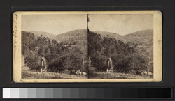
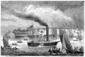
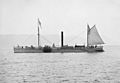
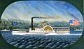
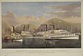
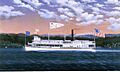
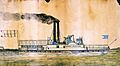
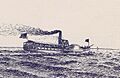
Historic Steamboats
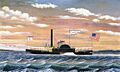
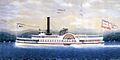
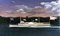
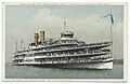
Because there weren't many roads, people mostly traveled by sloops (a type of sailboat). These boats made regular trips up and down the river. Later, Steamboats were built to travel the Hudson, carrying both people and goods. Steamboats provided most of the transportation to New York City. Steamboat travel in Rockland started with a local steam vessel called the "Orange." Some called her "Pot-Cheese" because she was beautiful, and others called her "The Flying Dutchman" because she was fast. She had a regular schedule between Nyack and New York. The North River Steamboat (often called Clermont) is seen as the world's first successful steamboat for business. It took twenty more years for a boat to be reliable enough to make a round trip in one day. This led to competition from steamboats built in Haverstraw and Tappan.
To help steamboat traffic from Tappan Landing, a road was built over the marshes to the end of a 500-foot (152.4 m) pier. Within a few years, this pier became the end point for the New York & Erie Railroad. Building this road greatly helped the county grow. It led to the founding of Piermont with its long pier. This made it possible to start several villages and use Rockland's mineral and farming resources. Other railroads followed. The first steamer to bring passengers to the railroad for the trip from Piermont to Ramapo was named "South American." The steamer "Utica" brought passengers from New York City when the Erie railroad opened to Goshen, New York.
-
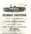
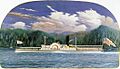
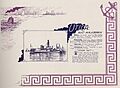
Chrystenah handbill
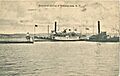
-
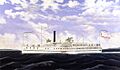
Steamship Albany
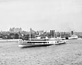
-
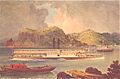
Chrystenah at Rockland Lake
-
Clermont
-
Clermont Replica
-
Confidence
-
Drew
-
Fanny
-
Harlem
-
Jesse Hoyt
-
Hendrick Hudson
-
Iron Witch
-
Milton Marti
-
Isaac Newto
-
Niagara
-
Isaac Smith
-
Robert L. Stevens
-
United States
-
Utica


.jpg)


.jpg)
_by_Bard.jpg)
_02.jpg)

_by_Bard.jpg)
_05.jpg)
_by_Bard.jpg)
.jpg)
_by_Bard_Bros.jpg)
_by_Stanton_cropped.jpg)
_02.jpg)
Hudson River Day liners included PS Alexander Hamilton, PS Chauncey Vibbard, and PS Washington Irving.
Important Hudson River steamboats included Chancellor Livingston (1816), James Kent (1823), DeWitt Clinton (1828), Robert L. Stevens (1835), Rip Van Winkle (1845), Isaac Newton (1846), Daniel Drew (1860), Thomas Cornell (1863), Chauncey Vibbard (1864), Dean Richmond(1864), Charles W. Morse (1904), Hendrick Hudson (1906), and Robert Fulton (1909). These were built or had engines made by companies like Allaire Iron Works, Cornelius H. DeLamater, Harlan and Hollingsworth, John Stevens, W. & A. Fletcher Company, and West Point Foundry.
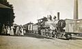
Historic Railroads
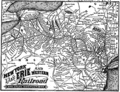
In 1833, the New York and Erie Railroad received a charter. Trains were running in the county by 1840. The New York and Erie Railroad was finished in 1851. It became the longest railroad in the U.S., stretching 483 miles (777 km) from Piermont to Dunkirk on Lake Erie. It was also the second-longest railroad in the world. The 13th President of the United States, Millard Fillmore, and the Secretary of State, Daniel Webster, along with many other officials, boarded the train at the Piermont Pier for the first trip.
In the 1800s, railroads, both for freight and passengers, were very important for Rockland County's development and growth. Many communities and villages grew near the train stations. Most post offices were also built near the stations. Passengers traveling to New York City would board steamers at Piermont. The first five locomotives were named "Eleazar Lord", "Piermont", ""Rockland", "Orange", and "Ramapo."
-
Pearl River Railroad Station
-
-

-
-


- -(A)- The New Jersey & New York Railroad – 1875
- Pearl River station
- Nanuet Crossing
- Spring Valley
- Union
- New Hempstead
- Summit Park
- Alexis
- Pomona
- Mount Ivy
- Theills
- West Haverstraw
- Haverstraw
- -(B)- New City Branch NJ&NY Railroad
- Nanuet Crossing
- Bardonia
- Germonds
- Durant
- New City
- -(C)- Erie Railroad Piermont Branch −1870
- Piermont station
- Orangeburg
- Blauvelt
- Nanuet Crossing
- Spring Valley
- Monsey
- Tallman
- Suffern
- -(D)- Northern Railroad of NJ – 1859
- Sparkill
- Piermont
- Grandview
- South Nyack
- Nyack
- -(E)- New York, West Shore & Buffalo Railroad −1883
- Tappan
- Orangeburg
- Blauveltville
- Rockland Park
- Nyack Turnpike
- Valley Cottage
- Congers
- Haverstraw
- (Fairmont Ave)
- West Haverstraw
- (Crugers by ferry)
- Stony Point
- Tomkins Cove
- Jones Point
- Iona Island
- -(F)- Main Line
- Suffern station
- Hillburn
- Ramapo
- Sterlington
- Sloatsburg
- -(G)- Sterlington Mountain Railway – May 18, 1864.
- Suffern
- Sterlington
Rockland County Places of Interest
Rockland County's Rocks

- Indian Rock – This huge 17,300-ton (15,695 metric tons) Proterozoic granite gneiss rock is between 800 million and 1.2 billion years old. It came from the Ramapo Mountains and Hudson Highlands. This giant rock was left in Montebello by the Laurentide Ice Sheet about 21,000 years ago.
- Maria's Rock – This rock is on the front lawn of Pfizer/Wyeth (Lederle Laboratories) on North Middletown Road in Pearl River. An 18th-century legend tells of a little girl named Maria who wandered from her home in nearby Tappan. She sadly died of hunger and cold. People say villagers found her bones near this huge boulder.
- Spook Rock – This is the largest of a group of rocks located on Spook Rock Road and Highview Avenue in Airmont. The Tappan and Warawankogs, who were part of the Lenni-Lenape Wolf Tribes and an Algonquian people, worshipped the sun, moon, stars, and a spirit called Manitou. The story says that a Dutch farmer's daughter was sacrificed here, and her ghost appears on the anniversary of her death.
The Dunderberg Spiral Railway
This was a fun railroad that was partly built in 1890–1891 but never finished. The first part of the ride would have taken the cars up two steep slopes to the top of the mountain, 900 feet (274.3 m) above the Hudson River. Visitors could get off there to enjoy the views. Then, the cars would have rolled down a nine-mile (14 km) scenic railway using only gravity. It would have had two spirals and three switchbacks. If it had been finished, it would still be the biggest roller coaster ever built!
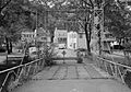
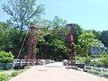
Piermont Hand-Cranked Drawbridge
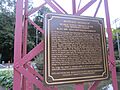
The Piermont hand-cranked drawbridge was first built in 1880 by The King Iron Bridge Company. This company from Cleveland, Ohio, built over 10,000 bridges in sixty years. Today, the hand-cranked drawbridge is used as a walkway for people. It connects to Tallman Mountain State Park. This bridge is the only hand-cranked drawbridge in Rockland County and possibly in the United States. In the past, fishermen on sloops (sailboats) going up and down the creek would get out of their boats. They would crank up the drawbridge, sail across, then get out and crank the drawbridge back down for cars. The entire bridge was taken apart, sent away for repair, and put back together exactly as it was. Allan King Sloan, whose great-great-grandfather founded the company, provided some information for the historical marker nearby. He also attended the dedication ceremony on August 7, 2009.
-
Sparkill Creek Drawbridge (1994)
-
Historical Marker 2009
-
Renovated Drawbridge (2012)
.jpg)


Art Gallery
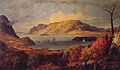
Historic Paintings
-
Gates of the Hudson
-
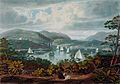
Looking North on the Hudson
-
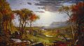
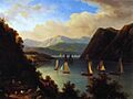
Autumn in America
-
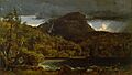
High Torne Mountain
-
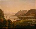
On the Hudson River
-
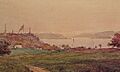
The Hudson at Piermont


The following artists studied at the Hudson River School:
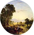
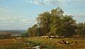
- Jasper Francis Cropsey (1823–1900)
- Francis Augustus Silva (American, 1835–1886).
- The Hudson at the Tappan Zee, 1876.
- Asher Brown Durand (1796–1886)
- Hudson River Scene, 1846.
- Hudson River Landscape, Date Unknown
- Régis François Gignoux (1816–1882)
- First Snow Along the Hudson River
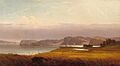
- James McDougal Hart (1828–1901)
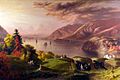
- Harriman New York Overlooking the Hudson
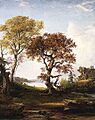
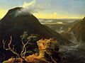
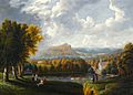
- Thomas Cole (1801–1848)
- Sunny Morning on the Hudson River
-
The Hudson at the Tappan Zee
-
Hudson River Scene
-
Hudson River Landscape
-
First Snow Along the Hudson River
-
Harriman New York Overlooking the Hudson
-
Sunny Morning on the Hudson River


- Victor DeGrailly (1845)
- Anthonys Nose on Hudson c1845
- George Wesley Bellows (1882–1925)
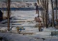
- A Morning Snow Hudson River
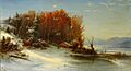
- Albert Bierstadt (1830–1902)
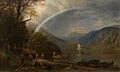
- Indian Summer Hudson River
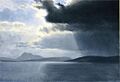
- Approaching Thunderstorm on the Hudson River
- Figures in a Hudson River Landscape
- Alfred Thompson Bricher (1837)
- Along The Hudson
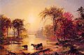
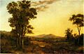
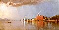
- Sandford Robinson Gifford (1823-1880)
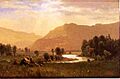
- Morning in the Hudson, Haverstraw Bay
-
Anthony's Nose on Hudson
-
A Morning Snow--Hudson River
-

Indian Summer Hudson River
-
Approaching Thunderstorm on the Hudson River
-
Figures in a Hudson River Landscape
-
Discovery of the Hudson River
-
Along The Hudson
-
West Point From Phillipstown
-
Autumn, Hudson River
-
View of the Hudson River from Tarrytown, Old Dutch Church, Beekman Manor House
-
View of the Hudson River by Robert Walter Weir, 1864
-
View of West Point from Fort Putnam
-
Up the Hudson
-
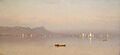
Morning in the Hudson, Haverstraw Bay

a.jpg)


.jpg)

