
West Point, New York facts for kids
Quick facts for kids
West Point, New York
|
|
|---|---|
.jpg)
Aerial view of West Point (at the center), the Hudson River, Highland Falls (on right), Cold Spring (on left) across the river in Putnam County
|
|

Location of West Point in Orange County, New York (right) and of Orange County in New York state (left)
|
|

West Point, New York
Location in New York
|
|
| Country | United States |
| State | New York |
| County | Orange |
| Town | Highlands |
| Area | |
| • Total | 19.34 sq mi (50.08 km2) |
| • Land | 18.43 sq mi (47.75 km2) |
| • Water | 0.90 sq mi (2.33 km2) |
| Population
(2020)
|
|
| • Total | 7,341 |
| • Density | 398.21/sq mi (153.75/km2) |
| Time zone | UTC−5 (Eastern (EST)) |
| • Summer (DST) | UTC−4 (EDT) |
| ZIP Codes |
10996–10997
|
| Area code(s) | 845 |
| FIPS code | 36-80747 |
West Point is the oldest military base in the United States that has been used without stopping. It is located on the Hudson River in New York. During the American Revolutionary War, General George Washington set up his headquarters here in 1779. He later called it "the most important Post in America" in 1781. West Point was also where General Benedict Arnold tried to betray the American forces during the war.
The United States Armed Forces first used West Point in January 1778. Brigadier General Samuel Holden Parsons and his soldiers moved in. Since then, the United States Army has always used West Point. The area covers about 25.1 square miles (65 km²) of land and water. This includes the campus of the United States Military Academy, which is also often called "West Point."
West Point is a special area called a census-designated place (CDP). It is in the town of Highlands in Orange County. It sits on the western side of the Hudson River. In 2020, about 7,341 people lived there. It is part of the larger New York City area.
Contents
History of West Point
Revolutionary War History
Building the Fort
West Point was chosen as a military site because of a sharp S-curve in the Hudson River. This curve made it a great spot to build defenses during the American Revolutionary War. In 1775, a group suggested building forts there.
Captain Louis de la Radiere started building the fort. However, New York Governor George Clinton felt he wasn't skilled enough. So, Polish Colonel Tadeusz Kościuszko finished the work between 1778 and 1780. This fort was very important for defense. It watched over the river's turn and the Great Chain.
On January 27, 1778, Brigadier General Samuel Holden Parsons and his soldiers crossed the frozen Hudson River. They climbed to the flat land at West Point to set up camp. General George Washington watched the building of the fort closely. He thought it was General Alexander McDougall's "first priority."
In 1778, Major General Israel Putnam wrote that West Point was the chosen place to block the Hudson River. A fort called Fort Clinton was built there. It was named after Governor Clinton's brother, Colonel James Clinton, whose soldiers built the main fort. The fort's southern and western walls were nine feet high and twenty feet thick. Three smaller forts and gun positions were built to the south. They were named Forts Meigs, Wyllys, and Webb.
.jpg)
After the Fort Was Built
West Point had a small group of Continental Army soldiers from 1776 until the end of the war. A huge iron chain was placed across the Hudson River in 1778. This was to stop British Navy ships from sailing further up the river. The British never tried to break through it.
The site included several small forts called redoubts. It also had Fort Putnam, which was on a high hill overlooking the river. This fort was named after its builder, General Rufus Putnam. It still looks the same as it did when it was built.
Close Calls for West Point
Capture of Stony Point and Verplanck's Point
The British Parliament told General Sir Henry Clinton to make George Washington leave West Point. Clinton decided to capture Stony Point and Verplanck's Point. These were important forts about twelve miles south of West Point. Clinton took these forts on June 1, 1779. To stop the British, Washington moved his soldiers further up the Hudson.
Benedict Arnold's Betrayal
In May 1779, General Benedict Arnold met with a merchant named Joseph Stansbury. Stansbury then went to Sir Henry Clinton and offered Arnold's "services." Clinton wanted to control the Hudson River. So, he was interested in getting information about West Point's defenses.
Arnold wrote letters to Clinton. In one letter on July 12, he offered to give West Point to the British. He later asked for £20,000. On August 3, 1780, Arnold became the commander of West Point. This also gave him control of the American-held part of the Hudson River.
Arnold then purposely made the fort's defenses weaker. He sent a letter to Clinton, suggesting a meeting with British Major John André. They would talk about West Point's plans. The meeting was set for September 11, but they didn't meet until September 21.
André was carrying the plans for West Point when three American soldiers captured him on September 23. They found the secret information about West Point. After Arnold's betrayal, the fort, which was sometimes called Fort Arnold, was renamed Fort Clinton. It was named after General James Clinton.
After the War
After the American Revolution ended, West Point was used to store cannons and other military items. Until November 28, 1779, it was also the temporary headquarters for George Washington. He called it "the most important Post in America" in 1781.
Congress didn't want a large standing army. So, they sent most American soldiers home. But they kept fewer than a hundred men at West Point. Even with so few soldiers, it was still the largest army post right after the Revolutionary War.
_crop.jpg)
Henry Knox and Alexander Hamilton thought West Point was a great location. In 1790, they suggested building a military academy there. However, the Congress said no at first. But earlier in 1790, a New York merchant named Stephen Moore sold his land, "Moore's Folly," to the United States. Congress made this sale official on September 10, 1790, for $11,085. This meant Congress fully owned the fort.
The United States Military Academy was finally started at West Point in 1802. It is the oldest military school in the country. It is also often called "West Point." West Point is special because it has been a continuously used military base for the longest time in the United States.
Geography and Climate

West Point is located at 41° 23′ 42″ N 73° 57′ 18″ W. The area covers about 25.1 square miles (65 km²). Most of this is land (24.3 sq mi or 63 km²), and a small part is water (0.7 sq mi or 1.8 km²). It is in the town of Highlands in Orange County. West Point and the nearby village of Highland Falls are on the western side of the Hudson River.
West Point has a humid continental climate. This means it has four clear seasons. Summers are hot and humid. Winters are cold with some snow. The average temperature in January is about 27.5°F (-2.5°C). In July, it's about 74.1°F (23.4°C).
On average, West Point gets about 51.47 inches (130.7 cm) of rain each year. It gets about 35.7 inches (90.7 cm) of snow per year, but this can change a lot. The hottest temperature ever recorded was 106°F (41°C) on July 22, 1926. The coldest was -7°F (-22°C) on January 22, 1984.
| Climate data for West Point, New York (1991–2010 normals, extremes 1890–present) | |||||||||||||
|---|---|---|---|---|---|---|---|---|---|---|---|---|---|
| Month | Jan | Feb | Mar | Apr | May | Jun | Jul | Aug | Sep | Oct | Nov | Dec | Year |
| Record high °F (°C) | 71 (22) |
77 (25) |
86 (30) |
96 (36) |
97 (36) |
102 (39) |
106 (41) |
105 (41) |
105 (41) |
92 (33) |
82 (28) |
72 (22) |
106 (41) |
| Mean daily maximum °F (°C) | 35.8 (2.1) |
38.9 (3.8) |
47.4 (8.6) |
60.4 (15.8) |
71.5 (21.9) |
79.9 (26.6) |
85.2 (29.6) |
83.3 (28.5) |
76.0 (24.4) |
63.4 (17.4) |
51.4 (10.8) |
40.7 (4.8) |
61.2 (16.2) |
| Daily mean °F (°C) | 28.2 (−2.1) |
30.6 (−0.8) |
38.5 (3.6) |
50.4 (10.2) |
61.1 (16.2) |
69.8 (21.0) |
75.3 (24.1) |
73.6 (23.1) |
66.4 (19.1) |
54.5 (12.5) |
43.5 (6.4) |
33.9 (1.1) |
52.1 (11.2) |
| Mean daily minimum °F (°C) | 20.7 (−6.3) |
22.4 (−5.3) |
29.5 (−1.4) |
40.5 (4.7) |
50.6 (10.3) |
59.8 (15.4) |
65.4 (18.6) |
63.9 (17.7) |
56.7 (13.7) |
45.6 (7.6) |
35.5 (1.9) |
27.1 (−2.7) |
43.1 (6.2) |
| Record low °F (°C) | −15 (−26) |
−17 (−27) |
−2 (−19) |
8 (−13) |
25 (−4) |
40 (4) |
40 (4) |
35 (2) |
28 (−2) |
20 (−7) |
5 (−15) |
−16 (−27) |
−17 (−27) |
| Average precipitation inches (mm) | 3.82 (97) |
2.95 (75) |
4.04 (103) |
4.00 (102) |
3.84 (98) |
4.61 (117) |
4.57 (116) |
4.96 (126) |
4.57 (116) |
5.29 (134) |
4.23 (107) |
4.59 (117) |
51.47 (1,307) |
| Average snowfall inches (cm) | 11.1 (28) |
7.1 (18) |
9.6 (24) |
0.4 (1.0) |
0.0 (0.0) |
0.0 (0.0) |
0.0 (0.0) |
0.0 (0.0) |
0.0 (0.0) |
0.0 (0.0) |
0.5 (1.3) |
7.0 (18) |
35.7 (91) |
| Average precipitation days (≥ 0.01 in) | 9.8 | 8.3 | 9.3 | 10.5 | 11.8 | 11.4 | 9.8 | 9.6 | 8.2 | 9.6 | 9.0 | 10.4 | 117.7 |
| Average snowy days (≥ 0.1 in) | 3.8 | 2.4 | 2.0 | 0.2 | 0.0 | 0.0 | 0.0 | 0.0 | 0.0 | 0.0 | 0.2 | 1.9 | 10.5 |
| Source: NOAA | |||||||||||||
People Living in West Point
| Historical population | |||
|---|---|---|---|
| Census | Pop. | %± | |
| 2010 | 6,763 | — | |
| 2020 | 7,341 | 8.5% | |
| U.S. Decennial Census | |||
In 2020, there were 7,341 people living in West Point. There were 860 households, with about 3.79 people per home. The population density was about 398 people per square mile (154 per km²).
Most people (69.3%) were white. About 5.4% were African American, and 4.4% were Asian. About 10.3% were from two or more races. People of Hispanic or Latino background made up 12.0% of the population.
About 23.5% of the people were under 18 years old. Only 0.4% were 65 or older.

Out of the 860 households, 79.5% were married couples. About 16.4% had a female head of household with no spouse. And 3.3% had a male head of household with no spouse. The average household income was $121,219. About 2.3% of the population lived below the poverty line.
West Point Mint
In 1937, a special building called the West Point Bullion Depository was built. It opened in 1938 to store silver bullion (precious metals). In 1988, it became the West Point Mint. This means it became an official branch of the United States Mint on March 31, 1988.
The West Point Mint holds a large amount of gold. It has about 54 million troy ounces of gold stored deep inside. The mint sits on a 4-acre (1.6 ha) piece of land.
Famous People from West Point
- Tony Hale, actor
- Edith Hoyt, painter
- Alfred Thayer Mahan, naval historian
- Ricky Steamboat, professional wrestler
- Gore Vidal, author
Getting Around West Point
U.S. Route 9W and NY Route 218 both run north and south through West Point. New York Route 293 also goes northeast to southwest through the base. U.S. Route 6 and the upper part of the Palisades Interstate Parkway run through the lower section of the town.
The New York Central Railroad used to run passenger trains through West Point's Gothic-style station until the 1950s. These trains went to Albany, Newburgh, and Kingston. Train service finally stopped in 1958.
Train Station Pictures
-
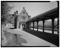
View of the West Shore Railroad station, looking north (around 1980)
-
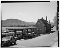
View of station, looking south (around 1980)
-
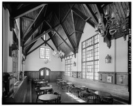
Inside the station
-
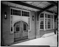
Entry door, view from the tracks
Education
The Highland Falls-Fort Montgomery Central School District is the local school district for West Point. James I. O'Neill High School is its high school.
The Department of Defense Education Activity (DoDEA) runs elementary and middle schools on the military base for children of military families. However, high school students whose parents are on the base go to O'Neill High School. In March 2022, West Point renewed its agreement with O'Neill High School.
See also
 In Spanish: West Point (Nueva York) para niños
