Sloatsburg, New York facts for kids
Quick facts for kids
Sloatsburg, New York
|
|
|---|---|

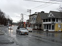
Route 17 in Sloatsburg
|
|

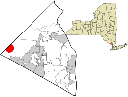
Location in Rockland County and the state of New York.
|
|
| Country | United States |
| State | New York |
| County | Rockland |
| Incorporated | October 7, 1929 |
| Area | |
| • Total | 2.54 sq mi (6.57 km2) |
| • Land | 2.50 sq mi (6.47 km2) |
| • Water | 0.04 sq mi (0.10 km2) |
| Elevation | 344 ft (105 m) |
| Population
(2020)
|
|
| • Total | 3,036 |
| • Density | 1,214.89/sq mi (469.11/km2) |
| Time zone | UTC−5 (EST) |
| • Summer (DST) | UTC−4 (EDT) |
| ZIP Code |
10974
|
| Area code(s) | 845 |
| FIPS code | 36-67708 |
| GNIS feature ID | 0965432 |
| Website | www.sloatsburgny.com |
Sloatsburg is a small village in Rockland County, New York, United States. It is part of the town of Ramapo. The village is located near the border of Orange County. It sits at the southern entrance to Harriman State Park, a large and beautiful park. In 2020, about 3,036 people lived here. The village got its name from Stephen Sloat, who was an early landowner in the area.
Contents
History of Sloatsburg
Early Days and Native Americans
The land where Sloatsburg is today was once hunting grounds for the Minsi band of the Leni Lenape Indians. These Native American people lived across much of the mid-Atlantic region. There was an important Indian path through the Ramapo Mountains here. This path later became a main road from New York to Albany. By 1800, it was known as the Orange Turnpike. Even today, major roads like the New York State Thruway and New York State Route 17 follow this old route.
European Settlers and the Sloat Family
In 1738, a Dutch colonist named Wynant Van Gelder bought the land from the Minsi. He later gave it to his father-in-law, Isaac Van Deusen, in 1747. Isaac then gave the land to his daughter, Marritge Van Deusen, and her husband, Stephen Sloat, in 1763.
The Sloats built a stone house and opened a tavern. This tavern was a regular stop for stagecoaches traveling between New York and Albany.
Sloatsburg During the Revolution
During the American Revolution, the Sloat House became a headquarters for American troops. These troops were stationed in the Ramapo Pass, which was an important strategic spot. George Washington, a famous leader, visited the area several times. He even stayed at Sloat's Tavern at least once in 1779. The Sloat House is still a private home today and is a recognized historical site.
Growth and Industry
After the war, the Sloat family started new businesses. They added a tannery (for making leather) and a cotton mill. Jacob Sloat, one of Stephen's sons, was very skilled with machines. In 1815, he opened a mill to make cotton cloth. He later patented a special way to make cotton twine in 1840. At its busiest, his mill produced about 8,000 pounds of twine each week! The family ran the mill until the American Civil War, when it temporarily closed because there wasn't enough cotton.
In the early 1800s, Abram Dater built an iron forge on the Ramapo River. Soon after, a grist mill (for grinding grain) and a saw mill were also built. Between 1836 and 1841, the Erie Railroad built a train line through Sloatsburg. This brought more people and helped the village grow.
Challenges and Changes
In 1903, a big flood destroyed most of the factories in Sloatsburg. Many of these factories were built close to the river to use its water power. Sadly, many were never rebuilt.
In the 1920s, during a time called Prohibition (when alcohol was illegal), Sloatsburg's quiet location near New York City made it a place where people illegally made and sold alcohol.
In 1929, Sloatsburg officially became a village. David Henion was elected as its first mayor.
The invention of the automobile changed Sloatsburg a lot. Before the New York State Thruway and the Palisades Parkway were built in the 1950s, traffic on the Orange Turnpike could get very bad. Cars would sometimes back up for miles!
Geography
Sloatsburg covers an area of about 6.5 square kilometers (2.5 square miles). Most of this area is land, with a small part being water. The western side of the village is next to Orange County.
Population Information
The population of Sloatsburg has changed over the years. Here's a look at how many people have lived in the village:
| Historical population | |||
|---|---|---|---|
| Census | Pop. | %± | |
| 1930 | 1,623 | — | |
| 1940 | 1,771 | 9.1% | |
| 1950 | 2,018 | 13.9% | |
| 1960 | 2,565 | 27.1% | |
| 1970 | 3,134 | 22.2% | |
| 1980 | 3,154 | 0.6% | |
| 1990 | 3,035 | −3.8% | |
| 2000 | 3,117 | 2.7% | |
| 2010 | 3,039 | −2.5% | |
| 2020 | 3,036 | −0.1% | |
| U.S. Decennial Census | |||
Arts and Culture
Sloatsburg has several interesting historical places. Five of these are listed on the National Register of Historic Places. These sites help tell the story of the village:
- The Glenwood Hotel was built in 1908. It used to be a place where mill workers could live.
- The Old Sloatsburg Cemetery is a very old burial ground. The first person buried there was Private John Sloat in 1781, during the Revolutionary War.
- The Sloatsburg Historical Society has displays about the history of the area. You can see artifacts from the Lenape and other Native American groups.
- The Sloatsburg Public Library also has exhibits. These include ancient artifacts found in a place called the Spring House Rock Shelter.
- The Sloat House and Inn is a stone house from the mid-1700s. It was a meeting place for important people during the Revolution.
- Sloat's Dam and Mill Pond is the only remaining dam on this part of the Ramapo River. It was first built in 1792.
- The Jacob Sloat House, also known as Harmony Hall, is a large mansion built in 1848.
Education
Students in Sloatsburg attend schools in the Suffern Central School District. Younger students go to Sloatsburg Elementary School. Middle school students (grades 6-8) attend Suffern Middle School. Older students go to Suffern High School.
Transportation
Train Service
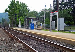
The Sloatsburg train station offers Metro-North train service. You can take a train on the Port Jervis Line to places like Hoboken, New Jersey. From Hoboken, you can connect to PATH trains to get to New York or Jersey City. You can also go to Secaucus, which connects to New York Penn Station and other places in New Jersey. In the other direction, the train line goes to Port Jervis.
Bus Service
Sloatsburg is the starting point for Transport of Rockland's bus line number 93.
Roads
New York State Route 17 runs through Sloatsburg and is known as Orange Turnpike. Interstate 87, also called the New York State Thruway, passes through the village. While there's no direct exit into Sloatsburg from the Thruway, exit 15A is signed for Sloatsburg. Seven Lakes Drive, which goes through Harriman State Park, begins in Sloatsburg.
Notable People
- John Drake Sloat (1781–1867) was a commodore in the United States Navy. In 1846, he claimed California for the United States and became its first military governor.
- Robert H. Gittins was a former US Congressman.
- Scott Wright is a professional wrestler and bodybuilder, also known as "Scotty Charisma".
See also
 In Spanish: Sloatsburg para niños
 | Bessie Coleman |
 | Spann Watson |
 | Jill E. Brown |
 | Sherman W. White |


