Haverstraw, New York facts for kids
Quick facts for kids
Haverstraw, New York
|
||
|---|---|---|
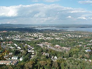
Skyline
|
||
|
||
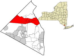
Location in Rockland County and the state of New York.
|
||
| Country | United States | |
| State | New York | |
| County | Rockland | |
| Settled | 1666 | |
| Established | 1788 | |
| Area | ||
| • Total | 27.41 sq mi (71.00 km2) | |
| • Land | 22.15 sq mi (57.38 km2) | |
| • Water | 5.26 sq mi (13.63 km2) | |
| Population
(2020)
|
||
| • Total | 39,087 | |
| Time zone | UTC-5 (Eastern (EST)) | |
| • Summer (DST) | UTC-4 (EDT) | |
| ZIP code |
10927
|
|
| Area code(s) | 845 | |
| FIPS code | 36-087-32765 | |
| Website | www.townofhaverstraw.org | |
Haverstraw is a town in Rockland County, New York, United States. It is located north of Clarkstown and Ramapo, east of Orange County, south of Stony Point, and west of the Hudson River. The town stretches across the northern part of the county from west to east. In 2020, about 39,087 people lived there.
The name "Haverstraw" comes from the Dutch words Haverstroo. This means "oats straw," which describes the grassy areas along the river. The town has three villages. One of these villages is also called Haverstraw. This village is the original center of government for the town. It has the historic downtown area and the most people in northern Rockland County.
Contents
History of Haverstraw
Early Settlement and Name Origin
In 1609, explorer Henry Hudson explored this area. A piece of land was bought from the local native people in 1666. This purchase was officially confirmed in 1671. The area was known as Haverstroo, which means "oat straw" in Dutch.
Haverstraw During the American Revolution
During the American Revolution, Haverstraw was very important. It served as a lookout point for British activities on the Hudson River. Col. Ann Hawkes Hay led this effort. You can hike a trail called the Long Path from Central Highway. It goes about 2 miles east along South Mountain to High Tor. Little Tor, the second highest peak on South Mountain, is halfway there.
Formation and Changes of the Town
The town of Haverstraw was officially formed in 1788. At that time, it was part of Orange County, New York. Later, in 1791, parts of Haverstraw were separated to create the towns of Clarkstown and Ramapo. In 1865, another part was used to form the town of Stony Point.
Early Community Experiments
In 1826, there was a short-lived attempt to create a special community in Haverstraw. It was called the Franklin Community and was based on ideas from Robert Owen. This community did not have enough money and had many disagreements. It closed after only five months.
Geography of Haverstraw
Haverstraw covers a total area of about 71 square kilometers (27.4 square miles). Most of this area, about 57.4 square kilometers (22.15 square miles), is land. The rest, about 13.6 square kilometers (5.26 square miles), is water. Water makes up about 19% of the town's total area.
Population and People
Population Growth Over Time
| Historical population | |||
|---|---|---|---|
| Census | Pop. | %± | |
| 1790 | 4,826 | — | |
| 1820 | 2,700 | — | |
| 1830 | 2,306 | −14.6% | |
| 1840 | 3,449 | 49.6% | |
| 1850 | 5,885 | 70.6% | |
| 1860 | 8,123 | 38.0% | |
| 1870 | 6,412 | −21.1% | |
| 1880 | 6,973 | 8.7% | |
| 1890 | 9,079 | 30.2% | |
| 1900 | 9,874 | 8.8% | |
| 1910 | 9,335 | −5.5% | |
| 1920 | 9,027 | −3.3% | |
| 1930 | 11,603 | 28.5% | |
| 1940 | 12,443 | 7.2% | |
| 1950 | 12,979 | 4.3% | |
| 1960 | 16,632 | 28.1% | |
| 1970 | 25,311 | 52.2% | |
| 1980 | 31,929 | 26.1% | |
| 1990 | 32,712 | 2.5% | |
| 2000 | 33,811 | 3.4% | |
| 2010 | 36,634 | 8.3% | |
| 2020 | 39,087 | 6.7% | |
| U.S. Decennial Census | |||
In 2000, there were 33,811 people living in Haverstraw. By 2020, the population had grown to 39,087 people.
Diversity in Haverstraw
Haverstraw is home to many different groups of people. In 2000, about 66% of the people were white, and about 10% were black or African American. About 3% were Asian, and about 16% were from other races. A large part of the population, about 31.7%, identified as Hispanic or Latino. Haverstraw has one of the largest Dominican communities in the United States. About 32.4% of the population is Dominican.
Age and Households
In 2000, about 26% of the people in Haverstraw were under 18 years old. About 10% were 65 years or older. The average age was 35 years. There were 11,255 households in the town. About 37% of these households had children under 18 living with them.
Transportation in Haverstraw
Haverstraw has several important roads. These include the Palisades Interstate Parkway, U.S. Route 9W, U.S. Route 202, and NY Route 45.
Ferry and Bus Services
Haverstraw is also a stop for the NY Waterway/Metro-North Railroad Haverstraw–Ossining Ferry. This ferry helps people travel across the Hudson River. Short Line buses also provide daily service. These buses travel along U.S. Route 9W to and from the Port Authority Bus Terminal in Midtown Manhattan. They also go to West Point Military Academy or Newburgh.
Railroad History
The New York Central's West Shore Railroad started operating along the Hudson River in 1883. Until 1958, it offered passenger train service between Albany and Weehawken Terminal in Weehawken, New Jersey. From Weehawken, passengers could take ferries to Manhattan. Passenger service between West Haverstraw and Weehawken stopped in 1959. The train tracks are still used today for freight trains. This line is now part of the CSX River Subdivision. It runs between North Bergen Yard in New Jersey and Selkirk, New York.
Communities and Locations
Haverstraw includes several smaller communities and interesting places:
- Bowline Point Town Park – A park on a peninsula in the Hudson River, east of Haverstraw.
- Garnerville – A small community southwest of West Haverstraw.
- Harriman State Park – Part of this large park is in the western area of the town.
- Village of Haverstraw – The main historic downtown area and original government center.
- Johnsontown – A community west of West Haverstraw, named after the Johnson brothers.
- Ladentown – Another small community in the town.
- Lake Kanawauke – A lake located in Harriman State Park, in the southwest part of the town.
- Lake Sebago – Also in Harriman State Park, in the southwest corner of the town.
- Lake Welch – A lake in Harriman State Park, near the western border of the town.
- Mount Ivy – A community near the southern border of the town.
- Pomona – A village that is partly in Haverstraw and partly in the town of Ramapo.
- Samsondale – A community located east of West Haverstraw.
- St. John's in the Wilderness – A small community.
- Thiells – A community west of West Haverstraw.
- West Haverstraw – A village within the town.
- Willow Grove – A community located on the northern border of the town.
Education in Haverstraw
The Roman Catholic Archdiocese of New York used to operate Catholic schools in Rockland County, including St. Peter Parish School in Haverstraw. The school was important to the community and had a growing number of students. It aimed to keep tuition low so that children from all backgrounds could attend.
Notable People from Haverstraw
Many interesting people have connections to Haverstraw:
- Walter S. Gurnee (1813-1903) – He was the 14th Mayor of Chicago from 1851 to 1853. The village of Gurnee, Illinois is named after him.
- Wilson P. Foss Jr. – An art collector and businessman.
- Abram Stevens Hewitt (1822–1903) – A teacher, lawyer, and iron manufacturer. He also served as a U.S. Congressman and a mayor of New York.
- Molly McGee (1952–1994) – A gridiron football player.
- Marty Springstead – An American League Umpire in baseball.
- Scott Stanford (1977) – A WWE Superstars play-by-play announcer for the Raw brand.
- Both the famous composer Kurt Weill and his wife, the actress and singer Lotte Lenya, are buried in Haverstraw.
- Robert Sterling Yard – A journalist and environmentalist.
Haverstraw was also home to three people who received the Medal of Honor, a very brave award:
- Nick Erickson – From the Navy, during the Spanish–American War.
- Michael A. Donaldson – From the 69th New York, during World War I.
See also
 In Spanish: Haverstraw para niños
 | John T. Biggers |
 | Thomas Blackshear |
 | Mark Bradford |
 | Beverly Buchanan |


