Wadsworth, Ohio facts for kids
Quick facts for kids
Wadsworth, Ohio
|
|
|---|---|

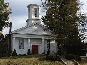
St. Mark Church
|
|

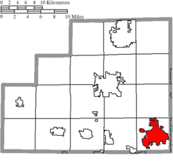
Location of Wadsworth in Medina County
|
|
| Country | United States |
| State | Ohio |
| County | Medina |
| Founded | March 1, 1814 |
| Incorporated | January 1, 1876 (village) |
| Incorporated | January 1, 1931 (city) |
| Government | |
| • Type | Mayor-Council |
| Area | |
| • Total | 11.34 sq mi (29.38 km2) |
| • Land | 11.34 sq mi (29.36 km2) |
| • Water | 0.01 sq mi (0.02 km2) |
| Elevation | 1,165 ft (355 m) |
| Population
(2020)
|
|
| • Total | 24,007 |
| • Density | 2,117.95/sq mi (817.72/km2) |
| Time zone | UTC-5 (Eastern (EST)) |
| • Summer (DST) | UTC-4 (EDT) |
| ZIP codes |
44281-44282
|
| Area code(s) | 234, 330 |
| FIPS code | 39-80304 |
| GNIS feature ID | 2397162 |
| Website | https://www.wadsworthcity.com/ |
Wadsworth is a city in Medina County, Ohio, United States. It was founded on March 1, 1814. The city got its name from General Elijah Wadsworth. He was a hero in the American Revolutionary War and an officer in the War of 1812. General Wadsworth owned a large part of the land that became Medina County. Wadsworth is a suburb of Akron. In 2020, about 24,007 people lived there.
Contents
History of Wadsworth
Wadsworth has a long history. A post office opened in the area in 1823. This helped people send and receive mail. It was an important step for the growing community.
Geography and Location
Wadsworth is located in Ohio. It covers about 10.62 square miles (27.51 square kilometers) of land. The city is just a few miles south of the Saint Lawrence River Divide. This is a natural boundary.
Wadsworth is about 11.6 miles (18.7 km) southwest of Akron. It is also about 32.8 miles (52.8 km) south of Cleveland. These larger cities are easy to reach from Wadsworth.
People of Wadsworth
| Historical population | |||
|---|---|---|---|
| Census | Pop. | %± | |
| 1880 | 1,219 | — | |
| 1890 | 1,576 | 29.3% | |
| 1900 | 1,764 | 11.9% | |
| 1910 | 3,073 | 74.2% | |
| 1920 | 4,742 | 54.3% | |
| 1930 | 5,920 | 24.8% | |
| 1940 | 6,495 | 9.7% | |
| 1950 | 7,966 | 22.6% | |
| 1960 | 10,635 | 33.5% | |
| 1970 | 13,142 | 23.6% | |
| 1980 | 15,187 | 15.6% | |
| 1990 | 15,718 | 3.5% | |
| 2000 | 18,437 | 17.3% | |
| 2010 | 21,567 | 17.0% | |
| 2020 | 24,007 | 11.3% | |
| Sources: | |||
In 2000, the average income for a family in Wadsworth was about $58,850. This shows how much money families earned. A small number of people and families lived below the poverty line. This means they had lower incomes.
Wadsworth in 2010
In 2010, the city had 21,567 people. There were 8,609 households, which are groups of people living together. Most people in Wadsworth were White (96.9%). Other groups included African American, Native American, and Asian people. About 1.2% of the population was Hispanic or Latino.
The average age in Wadsworth was 38.7 years old. About 25.6% of residents were under 18. This means many young people live in the city. About 15.8% were 65 or older. The city had slightly more females (51.9%) than males (48.1%).
Many adults in Wadsworth have a good education. About 31.2% of people over 25 had a bachelor's degree or higher. This shows a focus on learning in the community.
Arts and Fun in Wadsworth
Wadsworth has a special yearly event called the Blue Tip Festival. It includes a parade, fun rides, and tasty foods. There are also games, shops, and entertainment. The festival is named after blue tip matches. These matches used to be made in Wadsworth until the 1980s.
The city also has the Wadsworth Public Library. It offers books, computers, and programs for everyone.
Education in Wadsworth
The Wadsworth City School District is the biggest employer in the city. This means it provides the most jobs. The community strongly supports its schools. Voters have approved funding for the schools many times.
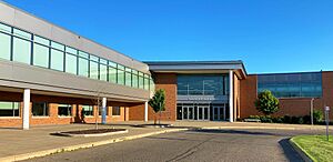
Wadsworth High School and Wadsworth Middle School are part of the Ohio High School Athletic Association. This means their sports teams compete against other schools in Ohio.
Another school in Wadsworth is Sacred Heart School. It is a Roman Catholic school. It teaches students from Kindergarten through 8th grade.
Media and News
Wadsworth gets its news from a daily newspaper. It is called The Medina County Gazette. This paper is published every day except Sunday. Larger newspapers like the Akron Beacon Journal and the Cleveland Plain Dealer also cover news in Wadsworth sometimes. The city can also receive many TV and radio stations. These stations come from the areas around Cleveland, Akron, and Canton.
Transportation and Roads
Wadsworth has two airports nearby. The Wadsworth Municipal Airport is 2 miles (3.22 km) southwest of the city. Skypark Airport is 2 miles west.
I-76 is a major highway that goes through Wadsworth. Other important state roads include OH-57, OH-94, and OH-261. These roads help people travel in and out of the city.
Famous People from Wadsworth
Many interesting people have come from Wadsworth.
- Dwier Brown is an actor. He was in the movie Field of Dreams.
- Nancy Everhard is also an actress.
- Scott Fletcher played professional baseball. He was an infielder in Major League Baseball.
- Michael Foreman is an astronaut. He has traveled to space.
- Ben Hess is a NASCAR driver.
- Drew Pearson is a songwriter. He has been nominated for a Grammy Award.
- Jim Renacci was a U.S. representative for Ohio. He was also the Mayor of Wadsworth.
- Laura Spelman Rockefeller was the wife of Standard Oil co-founder John D. Rockefeller.
- Bishop Sankey played professional football as an NFL running back.
- Andy Sonnanstine was a Major League Baseball pitcher.
- Carolyn Treffinger writes books for children.
Images for kids
See also
 In Spanish: Wadsworth (Ohio) para niños
 | Delilah Pierce |
 | Gordon Parks |
 | Augusta Savage |
 | Charles Ethan Porter |


