Waimea River (Oahu) facts for kids
Quick facts for kids Waimea River |
|
|---|---|

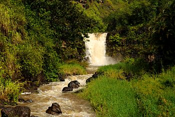
Waimea Falls on the Kamananui stream a tributary of the Waimea
|
|
|
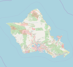
Location of the mouth within Oahu
|
|
| Country | United States |
| State | Hawaii |
| County | Honolulu County |
| Physical characteristics | |
| Main source | Waimea Valley |
| River mouth | Waimea Bay 21°38′27″N 158°03′48″W / 21.64074°N 158.06324°W |
| Length | 1.5 mi (2.4 km) |
| Basin features | |
| Basin size | 13.6 sq mi (35 km2) |
The Waimea River is a short but important river located in Honolulu County on the island of Oʻahu in Hawaii. Its name, Waimea, means "red water" in the Hawaiian language. This river is a key part of the beautiful Waimea Valley.
About the Waimea River
The main part of the Waimea River is about 1.5 miles (2.4 km) long. However, if you include all the smaller streams that flow into it, the total length is much longer. The river's water comes from an area called a watershed, which covers about 13.6 square miles.
Where Does It Flow?
The Waimea River starts when two streams, the Kamananui stream and the Kaiwikoʻele stream, join together. This happens northeast of a town called Haleiwa. From there, the river flows northwest. It travels through the scenic Waimea Valley before reaching the Pacific Ocean at Waimea Bay.
Cool Waves at the Bay
The place where the Waimea River meets the ocean is famous for its waves. Sometimes, the sand builds up and blocks the river from flowing directly into the bay. When this happens, people living nearby sometimes dig a channel in the sand. This helps the river water drain out, and it can create some really cool waves that surfers love!
 | Misty Copeland |
 | Raven Wilkinson |
 | Debra Austin |
 | Aesha Ash |


