Waimea River (Kauai) facts for kids
Quick facts for kids Waimea |
|
|---|---|
 |
|
| Country | United States |
| State | Hawaii |
| Region | Kauai |
| Physical characteristics | |
| Main source | Alaka'i Swamp (confluence of the Waiahulu and Po'omau streams) 22°05′25″N 159°39′19″W / 22.09028°N 159.65528°W |
| River mouth | Waimea, Kauai County, Hawaii 21°57′17″N 159°39′35″W / 21.95472°N 159.65972°W |
| Length | 12 mi (19 km) |
| Basin features | |
| Tributaries |
|
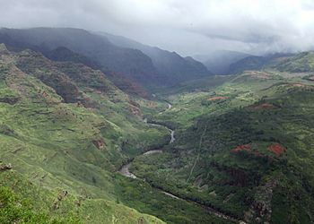
The Waimea River is a very important river on the island of Kauai in the U.S. state of Hawaii. It is about 12.1 miles (19.5 km) long, making it one of the longest rivers in the Hawaiian Islands. This river helps drain a huge part of the island, about one-sixth of its total area!
The river starts high up in a very wet area called the Alaka'i Swamp. This swamp is the biggest high-elevation swamp in the entire world. From there, the Waimea River flows south.
Journey Through Waimea Canyon
As the Waimea River flows, it carves its way through the amazing Waimea Canyon. This canyon is super deep, about 3,000-foot-deep (910 m)! It's so impressive that people often call it the "Grand Canyon of the Pacific." Imagine a river creating such a huge, beautiful valley over many, many years!
Life Along the River Valleys
Long ago, the valleys of the Waimea River and its smaller river friend, the Makaweli River, were home to many people. These areas were once very busy and full of life.
Where the River Meets the Ocean
Finally, the Waimea River reaches the Pacific Ocean at a town called Waimea. This spot is famous because it's near where Captain Cook first landed on Kauai way back in 1778. It's a place with a lot of history!
 | Aurelia Browder |
 | Nannie Helen Burroughs |
 | Michelle Alexander |


