Walland Marsh facts for kids
Walland Marsh is a special area of flat, low-lying land that is part of the larger Romney Marsh. Most of Walland Marsh is in Kent, a county in England, with a smaller part in East Sussex. Its name, Walland, means "wall-land," which makes sense because its northern border is marked by a long, ancient structure called the Rhee Wall.
Contents
The Rhee Wall: A Historic Boundary
The Rhee Wall is a very old, man-made structure that stretches for about 7.5 miles (12 kilometers). It runs from a village called Appledore, through Brenzett and Old Romney, all the way to New Romney. This wall is made up of two earth banks that run side-by-side, usually 50 to 100 meters (about 164 to 328 feet) apart. The land between these banks is higher than the marsh on either side.
Why Was the Rhee Wall Built?
The Rhee Wall was built in the 13th century, which was a very long time ago! Its main purpose was to act as a water channel. People hoped this channel would help wash away silt (fine dirt and sand) from the busy harbour at New Romney. Harbours are important places where ships can dock. Over time, silt can build up and make the water too shallow for ships.
Unfortunately, this plan didn't work out as expected. The Rhee Wall hasn't held water since the Middle Ages. Even though it didn't serve its original purpose for long, it remains an important historical feature of the marsh.
Where is Walland Marsh?
Walland Marsh has specific borders. To its southeast, you'll find the town of Lydd. Beyond Lydd is another marshy area called Denge Marsh. To the southwest, Walland Marsh is bordered by the historic town of Rye.
Several small villages are located right within the Walland Marsh area. These include Fairfield, Brookland, and East Guldeford.
How Walland Marsh Became Farmland
Centuries ago, Walland Marsh was transformed into useful farmland. Most of this land was reclaimed between the 13th and 15th centuries. This process happened a bit later than the reclamation of Romney Marsh, which is to the northeast.
The Process of Land Reclamation
Land reclamation was done in stages using a method called innings. Here's how it worked:
- First, a large embankment (a raised bank of earth) was built around a section of the marsh.
- Then, at low tide, the water inside this enclosed area would drain away.
- This process slowly turned the wet, marshy land into drier, more productive ground suitable for farming.
Keeping the Land Dry: Drainage Systems
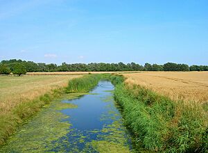
To make sure the reclaimed land stayed useful for farming, people created special drainage channels. These channels are known locally as sewers (but they're not the kind that carry waste!). They are simply ditches or canals designed to carry water away from the land.
A well-known example is the White Kemp Sewer, which flows right across the middle of Walland Marsh. This sewer eventually joins up with the Jury's Gap Sewer, which then leads all the way to the coast at Jury's Gap, near the famous Camber Sands. These drainage systems are still important today for keeping the marsh productive.
 | Percy Lavon Julian |
 | Katherine Johnson |
 | George Washington Carver |
 | Annie Easley |


