
Waring, Texas facts for kids
Quick facts for kids
Waring, Texas
|
|
|---|---|
.jpg)
Old gas station in Waring
|
|

Waring, Texas
Location in Texas

Waring, Texas
Location in the United States
|
|
| Country | United States |
| State | Texas |
| County | Kendall |
| Elevation | 1,345 ft (410 m) |
| Time zone | UTC-6 (Central (CST)) |
| • Summer (DST) | UTC-5 (CDT) |
| ZIP code |
78074
|
| GNIS feature ID | 1349492 |
Waring is a small, quiet community located in the beautiful Kendall County, Texas, in the United States. It's not a big city with its own mayor or city council, but a special kind of place called an unincorporated community. This means it's part of the county but doesn't have its own separate local government. Waring is nestled along the Guadalupe River, which is a lovely spot for nature lovers. It's about 1,345 feet (410 meters) above sea level.
Even though Waring is unincorporated, it has its own post office with the ZIP code 78074. This community is also part of the larger San Antonio Metropolitan Statistical Area. This means it's connected to the bigger San Antonio city area.
History of Waring
Waring was founded in 1887 by a person named R.P.M. Waring. He named the community after his hometown, Waringford, which is in Ireland. The name stayed the same until 1901.
For many years, from when it was founded until 1970, Waring was an important stop on a railway line. This railway connected to Kerrville and was part of the San Antonio and Aransas Pass Railway.
Getting Around Waring
If you visit Waring, you'll find a few main roads that help people get around. These roads connect Waring to other nearby places and are important for daily travel.
- Waring Welfare Road
- Farm to Market Road 1621
Population Over Time
The number of people living in Waring has changed over the years. Here's a look at how the population has grown and shrunk at different times:
| Historical population | |||
|---|---|---|---|
| Census | Pop. | %± | |
| 1890 | 100 | — | |
| 1900 | 150 | 50.0% | |
| 1910 | 200 | 33.3% | |
| 1920 | 300 | 50.0% | |
| 1930 | 284 | −5.3% | |
| 1950 | 80 | — | |
| 1970 | 73 | — | |
| 1990 | 73 | — | |
| 2000 | 59 | −19.2% | |
| 2010 | 73 | 23.7% | |
Images for kids
-
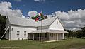
Waring School
-
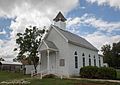
Waring Church
-
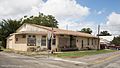
Office building
.jpg)
.jpg)
.jpg)
