
Warrington, Florida facts for kids
Quick facts for kids
Warrington, Florida
|
|
|---|---|

Location in Escambia County and the state of Florida
|
|
| Country | |
| State | |
| County | Escambia |
| Area | |
| • Total | 8.02 sq mi (20.76 km2) |
| • Land | 6.93 sq mi (17.95 km2) |
| • Water | 1.08 sq mi (2.81 km2) |
| Elevation | 52 ft (16 m) |
| Population
(2020)
|
|
| • Total | 15,218 |
| • Density | 2,195.64/sq mi (847.69/km2) |
| Time zone | UTC−6 (Central (CST)) |
| • Summer (DST) | UTC−5 (CDT) |
| FIPS code | 12-75200 |
| GNIS feature ID | 0292895 |
Warrington is a special kind of community in Escambia County, Florida. It's called a census-designated place (CDP). This means it's a place that the government counts as a town for population numbers, even though it's not officially a city with its own local government.
Warrington is located in Florida, right between the city of Pensacola and the state line with Alabama. It's about 6 miles (10 km) from both.
In 2020, about 15,218 people lived in Warrington. This was a bit more than the 14,531 people counted in 2010. Warrington is part of a larger area called the Pensacola–Ferry Pass–Brent, Florida Metropolitan Statistical Area. This area includes several towns and cities that are close to each other.
In 1975, people in Warrington voted on whether to become an official town, but it didn't happen. Even though Warrington has its own post office, mail sent to addresses in its ZIP code (32507) is handled by Pensacola.
A very important place in Warrington is Naval Air Station Pensacola. This is a big base for the United States Navy. It has its own ZIP code (32508) and is even counted as its own special area called "Pensacola Station" for census purposes.
Contents
History of Warrington
Warrington got its name from a man named Lewis Warrington. He was an important officer in the United States Navy. He even served as the Secretary of the Navy for a short time.
Lewis Warrington helped choose the spot where the Naval Air Station Pensacola was built. He was also the very first leader of the Navy Yard when it started in 1826.
Warrington was created soon after the Pensacola Navy Yard began in 1826. Another Navy leader, Commodore Melancthon Taylor Woolsey, helped build two small towns outside the Navy Yard for people to live in. These towns were Warrington and Woolsey. Warrington was located between the Navy Yard and Fort Barrancas.
In the 1930s, the town of Warrington was moved. It was relocated to the north of Bayou Grande. This move made more space available for the growing Naval Air Station.
Geography and Climate
Warrington is located at a specific point on the map: 30.385698 degrees North and -87.289594 degrees West.
The area of Warrington is about 8.9 square miles (23.0 square kilometers). Most of this area, about 6.9 square miles (17.9 square kilometers), is land. The rest, about 2.0 square miles (5.1 square kilometers), is water. This means that about 22% of Warrington's total area is covered by water.
Weather in Warrington
Warrington has a warm climate, typical of Florida. Here's a look at the average temperatures and rainfall:
| Climate data for Pensacola Forest Sherman NAS, Florida, 1981–2010 normals, extremes 1949–present | |||||||||||||
|---|---|---|---|---|---|---|---|---|---|---|---|---|---|
| Month | Jan | Feb | Mar | Apr | May | Jun | Jul | Aug | Sep | Oct | Nov | Dec | Year |
| Record high °F (°C) | 80 (27) |
82 (28) |
85 (29) |
95 (35) |
96 (36) |
103 (39) |
104 (40) |
105 (41) |
98 (37) |
92 (33) |
86 (30) |
82 (28) |
105 (41) |
| Mean daily maximum °F (°C) | 60.3 (15.7) |
63.3 (17.4) |
68.4 (20.2) |
74.4 (23.6) |
81.9 (27.7) |
87.1 (30.6) |
89.0 (31.7) |
88.6 (31.4) |
85.7 (29.8) |
78.4 (25.8) |
70.3 (21.3) |
62.7 (17.1) |
75.8 (24.4) |
| Mean daily minimum °F (°C) | 42.0 (5.6) |
45.3 (7.4) |
50.5 (10.3) |
57.0 (13.9) |
65.5 (18.6) |
72.1 (22.3) |
74.5 (23.6) |
74.5 (23.6) |
70.2 (21.2) |
59.9 (15.5) |
51.1 (10.6) |
44.7 (7.1) |
58.9 (15.0) |
| Record low °F (°C) | 6 (−14) |
12 (−11) |
21 (−6) |
32 (0) |
44 (7) |
46 (8) |
61 (16) |
59 (15) |
46 (8) |
31 (−1) |
21 (−6) |
7 (−14) |
6 (−14) |
| Average precipitation inches (mm) | 4.52 (115) |
5.11 (130) |
5.47 (139) |
4.04 (103) |
4.08 (104) |
5.70 (145) |
7.40 (188) |
5.78 (147) |
6.16 (156) |
4.94 (125) |
3.85 (98) |
4.15 (105) |
61.2 (1,555) |
| Average rainy days (≥ 0.01 in) | 9 | 8 | 8 | 6 | 6 | 9 | 13 | 13 | 9 | 7 | 7 | 9 | 104 |
Population and People
The population of Warrington has changed over the years. Here's how many people have lived there during different census counts:
| Historical population | |||
|---|---|---|---|
| Census | Pop. | %± | |
| 1950 | 13,570 | — | |
| 1960 | 16,752 | 23.4% | |
| 1970 | 15,848 | −5.4% | |
| 1980 | 15,792 | −0.4% | |
| 1990 | 16,040 | 1.6% | |
| 2000 | 15,207 | −5.2% | |
| 2010 | 14,531 | −4.4% | |
| 2020 | 15,218 | 4.7% | |
| source: | |||
In 2000, there were 15,207 people living in Warrington. These people lived in 6,547 households, and 4,046 of those were families.
The people in Warrington come from many different backgrounds. In 2000, about 71.57% of the people were White, and 21.69% were African American. There were also people who identified as Native American, Asian, Pacific Islander, or from two or more races. About 2.88% of the population was Hispanic or Latino.
Many households in Warrington have children. In 2000, about 28.4% of households had children under 18 living with them. The average household had 2.32 people, and the average family had 2.89 people.
The age of people in Warrington varies. In 2000:
- About 25.7% of the people were under 18 years old.
- About 9.4% were between 18 and 24 years old.
- About 27.7% were between 25 and 44 years old.
- About 21.8% were between 45 and 64 years old.
- About 15.4% were 65 years old or older.
The average age in Warrington was 36 years.

Education
Children in Warrington go to schools that are part of the Escambia County School District. This school district manages all the public schools in Escambia County.
Images for kids
-
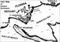
Sketch showing 1861 harbor defenses for Pensacola Bay. The town of Warrington (shown east of Fort Barrancas) was moved north of Bayou Grande in the 1930s, to provide land for Naval Air Station Pensacola.
See also
 In Spanish: Warrington (Florida) para niños
