Waslala facts for kids
Quick facts for kids
Waslala
|
|
|---|---|
|
Municipality
|
|

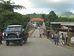
Bridge and entrance to the city of Waslala in 2008.
|
|
| Country | |
| Region | |
| Area | |
| • Municipality | 736 sq mi (1,905 km2) |
| Population
(2022 estimate)
|
|
| • Municipality | 58,735 |
| • Density | 79.855/sq mi (30.832/km2) |
| • Urban | 12,547 |
| Time zone | UTC-6 (Central Time) |
| • Summer (DST) | UTC-6 (No DST) |
| Climate | Am |
Waslala is a town and a municipality in the North Caribbean Coast Autonomous Region of Nicaragua. A municipality is like a local government area. Waslala is about 71 miles from Matagalpa and 161 miles from Managua, the capital city.
This area was greatly affected by the Nicaraguan Revolution. Many guerrilla fights happened here during that time.
Today, the main town of Waslala has modern services. This includes electricity, television, cable, and cell phone service. However, many of the 95 smaller communities around Waslala do not have these services. Some businesses in these areas use generators for a limited power supply.
Many groups are working in Waslala to help the people. They focus on building the local economy. They also work to improve the health of the people who live there. Examples of these groups include Water for Waslala and Pigs for Kids.
Climate in Waslala
Waslala has a tropical climate. This means it is warm all year round. There are two main seasons: a wet season and a dry season.
Natural Landscape
Waslala and the areas around it are very green. They are covered with lots of plants and trees. You can find rivers and streams full of water. The forests and countryside offer beautiful views.
However, Nicaragua has faced deforestation. This means many trees have been cut down. Waslala was also affected by this. Farmers cut down trees to create space for their farms.
See also
 In Spanish: Waslala para niños
 | Toni Morrison |
 | Barack Obama |
 | Martin Luther King Jr. |
 | Ralph Bunche |


