
Water Branch (Richardson Creek tributary) facts for kids
Quick facts for kids Water Branch |
|
|---|---|


Location of Water Branch mouth
|
|
| Other name(s) | Tributary to Richardson Creek |
| Country | United States |
| State | North Carolina |
| County | Union |
| Physical characteristics | |
| Main source | Cribs Creek divide pond about 1 mile west of Fountain Hill, North Carolina 525 ft (160 m) 35°04′15″N 080°18′13″W / 35.07083°N 80.30361°W |
| River mouth | Richardson Creek about 1.5 miles northeast of Olive Branch, North Carolina 298 ft (91 m) 35°07′24″N 080°17′34″W / 35.12333°N 80.29278°W |
| Length | 3.47 mi (5.58 km) |
| Basin features | |
| Progression | north |
| River system | Pee Dee |
| Basin size | 6.48 square miles (16.8 km2) |
| Tributaries |
|
| Bridges | NC 218, Burnsville Road, Jerusalem Church Road |
Water Branch is a small stream, about 3.47 mi (5.58 km) long, located in Union County, North Carolina. It flows into a larger stream called Richardson Creek.
Contents
Water Branch: A North Carolina Stream
Water Branch is a tributary, which means it's a smaller stream that flows into a bigger one. It's part of the larger Pee Dee River system.
Where Does Water Branch Flow?
Water Branch starts in a pond about 1 mile west of a place called Fountain Hill, North Carolina. From there, it flows north. It travels for about 3.47 mi (5.58 km) before joining Richardson Creek. This meeting point is about 1.5 miles northeast of Olive Branch.
What is the Water Branch Watershed?
A watershed is like a big bowl that collects all the rain and snowmelt in an area, and then drains it into a specific stream or river. The Water Branch watershed covers an area of about 6.48 square miles (16.8 km2).
This area gets a good amount of rain, about 48.0 inches each year. A large part of the watershed, about 36%, is covered by forests. These forests help keep the water clean and provide homes for many plants and animals.
Images for kids
-
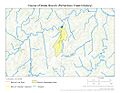
This map shows the path of Water Branch in Union County, North Carolina.
-
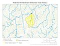
This map shows the entire area that drains into Water Branch.
.jpg)
.jpg)
