Watheroo, Western Australia facts for kids
Quick facts for kids WatherooWestern Australia |
|
|---|---|

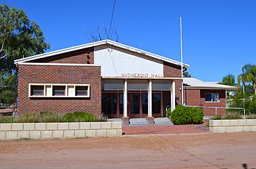
Watheroo Hall, 2013.
|
|
| Established | 1907 |
| Postcode(s) | 6513 |
| Elevation | 263 m (863 ft) |
| Area | [convert: needs a number] |
| Location |
|
| LGA(s) | Shire of Moora |
| State electorate(s) | Moore |
| Federal Division(s) | Durack |
Watheroo is a small town in the Wheatbelt area of Western Australia. About 137 people live there, based on the 2021 census count.
Contents
Watheroo's History
The land around Watheroo was first settled by James Oliver in 1851. The area was mapped in 1871, and the name Watheroo appeared on maps for the first time. Today, Watheroo is a busy farming town in the Wheatbelt. Farmers here raise animals and grow grain.
The town was an original stop on the Midland Railway Company line. This railway went all the way to Walkaway. Watheroo officially became a town in 1907.
The Railway and Floods
In 1907, heavy floods hit the Moore River. This caused the railway lines between Watheroo and Moora to close for a while. Parts of the track were washed away by the water.
Rail services were affected again in 1917. About 1.7 inches (43 mm) of rain fell in just three hours. This led to more floods and damaged tracks. The train yard in Watheroo was also covered in water.
What Does Watheroo Mean?
The name Watheroo comes from the Indigenous Australian language. It was the name of a natural spring nearby.
The word Watheroo might come from wardo, which means "little bird." It could specifically refer to the willy wagtail, a small bird. Another idea is that it comes from wardoro, which means "water."
Watheroo's Climate
| Climate data for Watheroo (1918–1959) | |||||||||||||
|---|---|---|---|---|---|---|---|---|---|---|---|---|---|
| Month | Jan | Feb | Mar | Apr | May | Jun | Jul | Aug | Sep | Oct | Nov | Dec | Year |
| Mean daily maximum °C (°F) | 33.9 (93.0) |
33.8 (92.8) |
31.0 (87.8) |
26.5 (79.7) |
21.3 (70.3) |
18.1 (64.6) |
17.2 (63.0) |
18.3 (64.9) |
21.1 (70.0) |
23.7 (74.7) |
28.1 (82.6) |
31.5 (88.7) |
25.4 (77.7) |
| Mean daily minimum °C (°F) | 15.9 (60.6) |
16.3 (61.3) |
14.8 (58.6) |
11.4 (52.5) |
8.0 (46.4) |
6.2 (43.2) |
5.0 (41.0) |
5.4 (41.7) |
6.5 (43.7) |
8.0 (46.4) |
11.2 (52.2) |
13.8 (56.8) |
10.2 (50.4) |
| Average precipitation mm (inches) | 9.4 (0.37) |
16.9 (0.67) |
22.1 (0.87) |
23.4 (0.92) |
58.8 (2.31) |
84.6 (3.33) |
78.4 (3.09) |
54.6 (2.15) |
30.1 (1.19) |
20.8 (0.82) |
9.4 (0.37) |
9.3 (0.37) |
417.2 (16.43) |
Watheroo has a warm climate, with hot summers and mild winters. The hottest months are January and February, when temperatures often reach over 30 degrees Celsius. The coolest months are July and August, but it rarely gets very cold. Most of the rain falls during the winter months, from May to August.
See also
 In Spanish: Watheroo para niños


