Moore River facts for kids
Quick facts for kids Moore River |
|
|---|---|

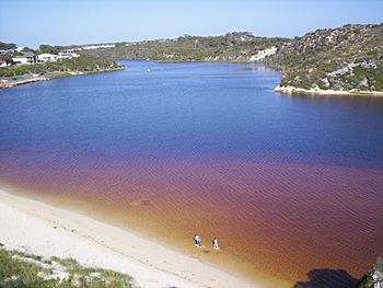
Moore River estuary at Guilderton
|
|
| Country | Australia |
| Physical characteristics | |
| Main source | Dalwallinu 310 m (1,017 ft) |
| River mouth | Indian Ocean at Guilderton sea level |
| Length | 193 km (120 mi) |
| Basin features | |
| Basin size | 13,550 km2 (5,232 sq mi) |
| Tributaries |
|
The Moore River is an important river located in the Wheatbelt area of Western Australia. It flows through different landscapes and is a key part of the local environment.
Contents
Where the Moore River Flows
The Moore River starts in areas like Perenjori, Carnamah, and Dalwallinu. It flows south through Moora, then west. Near Mogumber, it joins with the Moore River East. The river continues west, flowing over the Edengerie Cascade and through the northern part of the Moore River Nature Reserve. Finally, it goes through the Gingin Scarp and empties into the Indian Ocean at Guilderton.
Moore River Catchment Area
The river's catchment area is the land where all the water drains into the river. This area stretches from just south of Three Springs all the way to Guilderton. It covers a huge area of about 13,800 square kilometres (5,328 sq mi).
Most of this land, about 80%, has been cleared for farming. Farmers grow crops like broadacre (large-scale) crops, but they are also starting to grow different plants in horticulture (gardening) and plant tree farms.
River Mouth and Water Quality
The place where the Moore River meets the ocean at Guilderton often closes off during summer. This happens because there isn't enough water flowing in the river, which allows a sandbar to form across the mouth.
The river has nine smaller areas that drain into it, called subcatchments. It also has several smaller rivers (tributaries) and lakes along its path. The water's salinity (how salty it is) changes a lot. Most of the river water is either brackish (a little salty) or saline (very salty). However, one part, Gingin Brook, stays fresh all year round.
History of the Moore River
The Aboriginal people who lived along the lower part of the river called it Garban. In May 1836, a man named Corporal Patrick Heffron renamed it the River Moore. He named it after his expedition leader, George Fletcher Moore, who was the Advocate-General (a top legal official). The group exploring the area included Moore, Heffron, and an Aboriginal man named Weenat.
Flooding Events
The Moore River can experience floods, especially after cyclones or tropical storms cross the coast further north.
- 1907 Flood: In 1907, heavy rains caused parts of the railway lines between Watheroo and Moora to wash away. This meant trains couldn't run for some time.
- 1917 Flood: More floods happened in 1917. About 1.7 inches (43 mm) of rain fell in just three hours in Mogumber, and similar amounts fell nearby. Moora was once again underwater, and train services in the area were stopped. Low-lying parts of other towns like Arrino, Three Springs, and Coorow were also flooded.
- 1932 Flood: In 1932, the river flooded again after a lot of rain fell in the Midland districts. The railway lines were washed away up to 30 feet (9 m) deep, which cut off Moora from Perth by both road and rail. The town of Moora was about 3 feet (1 m) underwater, and some parts of the town had to be evacuated. Farmers lost crops and some animals because of the floodwaters.
See also
 In Spanish: Río Moore para niños
 | Sharif Bey |
 | Hale Woodruff |
 | Richmond Barthé |
 | Purvis Young |

