Waverley Rail Trail facts for kids
Quick facts for kids Waverley Rail Trail |
|
|---|---|

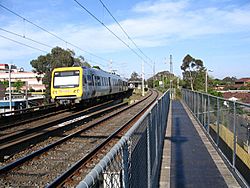
Bridge over Warrigal Rd looking west
|
|
| Location | Melbourne, Victoria, Australia |
| Cycling details | |
| Trail difficulty | Easy to medium |
| Hazards | Road crossings |
| Surface | Bitumen and concrete |
| Hills | Moderate hills |
| Water | none |
| Connecting transport | |
| Train(s) | Glen Waverley line |
| Tram(s) | None |
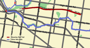
| Trail map | |
 |
|
The Waverley Rail Trail is a cool path in Melbourne, Australia. It's designed for both cyclists and pedestrians. This path follows the old Glen Waverley railway line. It stretches from Holmesglen railway station all the way to Glen Waverley railway station in Melbourne's south-eastern suburbs.
Exploring the Path
This adventure starts at the eastern end of Holmesglen railway station. You have two ways to begin your journey here.
- You can cross Warrigal Road at the traffic lights. Then, join the trail on the southern side of the railway line.
- Or, you can cross the railway bridge on the northern side. Walk about 200 meters. You'll find a pedestrian crossing over the railway line.
The path continues until you reach Paringa Court. It then crosses Power Avenue. After that, it goes up Railway Parade South to Huntingdale Road. You'll cross Huntingdale Road at the traffic lights. The trail then leads through the Jordanville railway station car park to Windsor Avenue.
The path goes to the end of Windsor Avenue. Then, it goes through the Mount Waverley railway station car park. The trail starts again at the eastern end of the platform. It keeps going to Blackburn Road. Here, you need to cross at the traffic lights. Continue past Syndal railway station and up Coleman Parade. The trail finishes at Glen Waverley railway station.
Connecting to Other Trails
The Waverley Rail Trail connects to other fun paths!
- Scotchmans Creek Trail and Gardiners Creek Trail: These trails are about 1 to 2 kilometers away. To get there, travel west from Warrigal Road at Holmesglen railway station. Cross the pedestrian bridge over Warrigal Road. This leads to Argyll Street. Walk to the end of Argyll Street. A short path goes up to Golfers Drive. Follow Golfers Drive on the path. It continues to Waverley Road. Then, it goes under the highway to reach the Scotchmans Creek Trail.
- Syndal Heatherdale Pipe Reserve Trail: This trail begins right at Syndal railway station.
- Dandenong Creek Trail: From Glen Waverley railway station, a special on-road route takes you to the Dandenong Creek Trail. This trail is located in Jells Park.
![]() Geographic data related to Waverley Rail Trail at OpenStreetMap
Geographic data related to Waverley Rail Trail at OpenStreetMap
 | Selma Burke |
 | Pauline Powell Burns |
 | Frederick J. Brown |
 | Robert Blackburn |

