
Weddell Point, Weddell Island facts for kids
Weddell Point is a special spot located on the west coast of Weddell Island in the Falkland Islands. It's a point of land that forms the southern edge of the entrance to a place called Skull Bay. It also sits on the east side of the Tea Island Passage.
Weddell Point is found at these coordinates: 51°54′10″S 61°08′03″W / 51.90278°S 61.13417°W. This helps people find its exact location on a map! It's about 13.2 kilometers (around 8 miles) northwest of Race Point. You can also find it just 1.1 kilometers (less than a mile) southeast of Tea Island and 1.5 kilometers (about a mile) south of Skull Bay Island.


Finding Weddell Point on Maps
Maps are super helpful for finding places like Weddell Point! They show us where different islands, bays, and points of land are located. Here are some maps that show Weddell Point and the surrounding area:
- The Falkland Islands. This is an older map from 1901.
- Falkland Islands Explorer Map. This map was made in 2007.
- Falklands Topographic Map Series. These maps were created between 1961 and 1979.
Images for kids
-
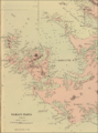
An old map of Weddell Island, showing Weddell Point.
-
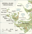
A more recent map of Weddell Island.


