
Werunda County facts for kids
Quick facts for kids WerundaNew South Wales |
|||||||||||||||
|---|---|---|---|---|---|---|---|---|---|---|---|---|---|---|---|

Location in New South Wales
|
|||||||||||||||
|
|||||||||||||||
Werunda County is a special area of land in New South Wales, Australia. It's one of 141 "cadastral divisions" in the state. Think of a cadastral division as a way to officially divide land into smaller parts for things like property records and maps.
This county is located in the western part of New South Wales. The famous Darling River forms its north-western border. Werunda County also includes Poopelloe Lake and the areas to the east and south-east of the town of Wilcannia.
The name Werunda is thought to come from a word used by the local Aboriginal people who lived in this area for thousands of years.
Understanding Land Divisions
What is a County?
In Australia, especially in New South Wales, a "county" is a very old way of dividing land. It's not like a county in some other countries that has its own government. Instead, these counties were created a long time ago to help with mapping, land ownership, and keeping records. They are like big sections on a giant map.
What are Parishes?
Inside each county, there are even smaller divisions called "parishes." Parishes are the smallest official land units. They are used for very detailed mapping and for keeping track of individual pieces of land, like farms or properties. Werunda County is divided into many different parishes. Most of these parishes are part of the Central Darling Shire, which is a local government area that manages services for the people living there.
Images for kids
-
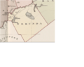
An old map from 1886 showing Werunda County in New South Wales.

