West Cape, Prince Edward Island facts for kids
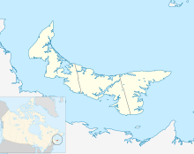
West Cape is a small community and a piece of land that sticks out into the ocean. It is located at the very western tip of Prince Edward Island (PEI) in Canada.
It's important to know that West Cape is the most western point of PEI. It's different from a place called West Point, which is a bit further south and east.
Contents
West Cape Wind Farm
West Cape is home to a very important project: the largest wind farm in Atlantic Canada! A wind farm is a place where many wind turbines are grouped together to make electricity.
How Big is the Wind Farm?
This huge wind farm stretches for about 10 kilometers (about 6 miles). It goes from Point Wolfe in the north down to West Point in the south. The whole area it covers is about 25 square kilometers (about 9.6 square miles).
How Much Power Does It Make?
The West Cape Wind Farm has 55 large wind turbines. These turbines work together to produce 99 megawatts of power. To give you an idea, that's enough electricity for many, many homes! This makes it even bigger than the Kent Hills Wind Farm in New Brunswick.
Where Does the Power Go?
About 10% of the electricity made here is sold to the city of Summerside on PEI. The rest of the power is sent out of the province. It travels through New Brunswick and then goes to markets in New England, which is a region in the United States.
Who Built It?
The wind farm was built in 2009 by a French company called GDF Suez. This company is now known as Engie. They leased the land from local owners in the area. When it was finished, the project cost about 200 million Canadian dollars. This was the biggest single construction project on Prince Edward Island since the Confederation Bridge was built in the 1990s.
 | Valerie Thomas |
 | Frederick McKinley Jones |
 | George Edward Alcorn Jr. |
 | Thomas Mensah |


