West Hatfield Historic District facts for kids
Quick facts for kids |
|
|
West Hatfield Historic District
|
|

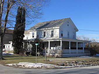
Corner of Linseed Rd and West St
|
|
| Location | Hatfield, Massachusetts |
|---|---|
| Area | 30 acres (12 ha) |
| Architectural style | Federal, Greek Revival |
| NRHP reference No. | 05000079 |
| Added to NRHP | February 24, 2005 |
The West Hatfield Historic District is a special old village area in West Hatfield, Massachusetts. It is located where West Street (US Route 5) meets Linseed Road and Church Avenue. This area grew in the 1800s because of the railroad. It became a busy place for moving farm products. Many people who moved from other countries also lived here. This historic district was added to the National Register of Historic Places in 2005.
Contents
What is the West Hatfield Historic District?
West Hatfield is on the edge of Hatfield's western uplands, which people call The Rocks. It is separated from other parts of town by Interstate 91. The district has many buildings spread out along Route 5. Church Avenue used to connect to the eastern parts of town, but the highway cut it off. Several old houses are also found on Church Avenue.
When Were These Buildings Built?
The oldest buildings in the district are from the 1830s. However, most of the 23 important buildings in the village were built in the early 1900s.
How Did West Hatfield Grow?
The village of West Hatfield really started to grow after the railroad was built in the 1840s. The railroad tracks were not near Hatfield's other main areas. This made West Hatfield a key spot for moving farm goods.
The Railroad's Importance
The railroad helped local farm products, like tobacco, get to markets. West Hatfield became a busy village around the train station. Many people from central and eastern Europe moved here. They mostly worked in farming. In the early 1900s, the village also got some of the first roadside shops. A few of these old shops can still be seen today.


