West Haven-Sylvan, Oregon facts for kids
Quick facts for kids
West Haven-Sylvan, Oregon
|
|
|---|---|

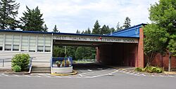
West Tualatin View Elementary School in the West Haven-Sylvan CDP
|
|

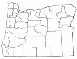
Location of West Haven-Sylvan, Oregon
|
|
| Country | United States |
| State | Oregon |
| Counties | Washington Multnomah |
| Area | |
| • Total | 2.26 sq mi (5.86 km2) |
| • Land | 2.26 sq mi (5.86 km2) |
| • Water | 0.00 sq mi (0.00 km2) |
| Elevation | 591 ft (180 m) |
| Population
(2020)
|
|
| • Total | 9,299 |
| • Density | 4,109.15/sq mi (1,586.51/km2) |
| Time zone | UTC-8 (Pacific (PST)) |
| • Summer (DST) | UTC-7 (PDT) |
| FIPS code | 41-80025 |
| GNIS feature ID | 2409550 |
West Haven-Sylvan is a special kind of community in Oregon, United States. It's called a census-designated place (CDP). This means it's an area that looks like a town but isn't officially a city. It's located in both Washington and Multnomah counties, just north of U.S. Route 26. In 2020, about 9,299 people lived here.
Contents
A Look Back in Time
In 1850, a pioneer named Nathan B. Jones, who arrived in Oregon in 1847, settled in this area. He planned to create a community he called "Zion Town." It's not known for sure if he named it after Mount Zion, a nearby hill.
However, there were already two other places in Oregon named "Zion" that had post offices. To avoid confusion, someone suggested the name "Sylvan." This name comes from Silvanus, a Roman god of the woods. A post office called Sylvan opened in 1890 but closed in 1906.
Nathan B. Jones was known for being a bit unusual and lived like a hermit. He really wanted Zion Town to become the new capital of Oregon. Sadly, Nathan B. Jones died in 1894. The old Sylvan post office was located where several roads meet today, including Sunset Highway and Skyline Boulevard, within the city limits of Portland.
Where is West Haven-Sylvan?
West Haven-Sylvan covers an area of about 2.3 square miles (5.86 square kilometers). All of this area is land, meaning there are no large lakes or rivers within its borders.
Who Lives Here?
| Historical population | |||
|---|---|---|---|
| Census | Pop. | %± | |
| 2020 | 9,299 | — | |
| U.S. Decennial Census | |||
In 2000, there were 7,147 people living in West Haven-Sylvan. The area had about 3,395 households. Most people living here were White (89.45%), but there were also people of African American, Native American, Asian, and Pacific Islander backgrounds. About 2.84% of the population was Hispanic or Latino.
The average household had about 2 people, and the average family had about 2.8 people.
Important Services
Local fire protection and emergency medical services (EMS) are provided by Tualatin Valley Fire and Rescue. There is also a hospital in the area called Providence St. Vincent Medical Center.
Schools in the Area
Children in West Haven-Sylvan attend schools in different districts depending on where they live. Most of the area in Washington County is part of the Beaverton School District 48J. A smaller part in the southeast, and all of the area in Multnomah County, is part of Portland School District 1J.
For students in the Beaverton School District, some of the schools they might attend include West Tualatin View Elementary School (which is located in West Haven-Sylvan), Cedar Park Middle School, and Beaverton High School. Students in the Portland School District are zoned for Bridlemile Elementary School, West Sylvan Middle School, and Lincoln High School.
Catlin Gabel School, a private school, is also located within West Haven-Sylvan.
See also
 In Spanish: West Haven-Sylvan para niños

