West Lafayette, Ohio facts for kids
Quick facts for kids
West Lafayette, Ohio
|
|
|---|---|
|
Village
|
|

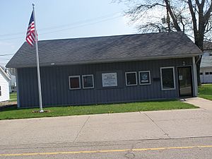
Town Hall
|
|

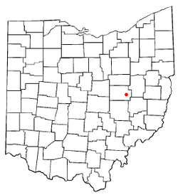
Location of West Lafayette, Ohio
|
|

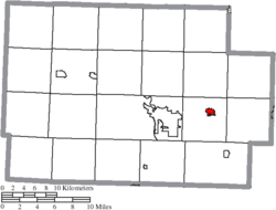
Location of West Lafayette in Coshocton County
|
|
| Country | United States |
| State | Ohio |
| County | Coshocton |
| Township | Lafayette |
| Area | |
| • Total | 0.86 sq mi (2.23 km2) |
| • Land | 0.86 sq mi (2.23 km2) |
| • Water | 0.00 sq mi (0.00 km2) |
| Elevation | 804 ft (245 m) |
| Population
(2020)
|
|
| • Total | 2,417 |
| • Density | 2,803.94/sq mi (1,082.38/km2) |
| Time zone | UTC-5 (Eastern (EST)) |
| • Summer (DST) | UTC-4 (EDT) |
| ZIP code |
43845
|
| Area code(s) | 740 |
| FIPS code | 39-83608 |
| GNIS feature ID | 2400133 |
| Website | http://www.westlafayettevillage.com/ |
West Lafayette is a small village located in Coshocton County, Ohio, in the United States. In 2020, about 2,417 people lived there. It's a friendly community with a rich history.
Contents
Village History
West Lafayette was started in 1850 by Robert Shaw and William Wheeler. Just five years later, in 1855, a railroad called the Steubenville and Indiana Railroad was built through the new town. This railroad line became very important. It was known as the Panhandle Route and was part of the Pennsylvania Railroad system. Today, the Columbus and Ohio River Railroad uses this line.
Train Accident Memorial
On September 11, 1950, a sad event happened on the railroad tracks. A passenger train called the "Spirit of St. Louis" had an accident with another train. This second train was carrying about 600 soldiers from the Pennsylvania National Guard. Sadly, 33 soldiers lost their lives. In 1990, a special memorial was placed near the accident site to remember them. A large 105mm howitzer (a type of cannon) is also at the memorial. It reminds everyone that 105mm shells were made at a local factory, Moore Enamelling, during World War II.
The "Enamel Center"
Before plastic was common, many household items were made from steel covered with a special ceramic coating called enamelware. West Lafayette was once known as the "Enamel Center of the World" because of this! The Lafayette Stamping and Enameling Co. started in 1903. Other companies like Moore Enameling and Jones Metal also made enamelware here.
Hometown Festival
The West Lafayette Homecoming started in 1950. Today, it's still a popular event known as the "Hometown Festival." It's a time for the community to come together and celebrate.
Village Geography
West Lafayette covers about 0.89 square miles (2.23 square kilometers) of land. The village is built on flat ground in the Tuscarawas River valley. It is surrounded by beautiful forested hills and farm valleys. The Ohio Central Railroad runs through the town. Just north of the village is U.S. Route 36, a main road that connects Columbus with places to the east.
Population Information
| Historical population | |||
|---|---|---|---|
| Census | Pop. | %± | |
| 1880 | 250 | — | |
| 1910 | 840 | — | |
| 1920 | 921 | 9.6% | |
| 1930 | 1,106 | 20.1% | |
| 1940 | 1,152 | 4.2% | |
| 1950 | 1,346 | 16.8% | |
| 1960 | 1,476 | 9.7% | |
| 1970 | 1,719 | 16.5% | |
| 1980 | 2,225 | 29.4% | |
| 1990 | 2,129 | −4.3% | |
| 2000 | 2,313 | 8.6% | |
| 2010 | 2,321 | 0.3% | |
| 2020 | 2,417 | 4.1% | |
| U.S. Decennial Census | |||
2010 Census Snapshot
In 2010, there were 2,321 people living in West Lafayette. There were 948 households and 642 families. Most of the people living in the village were White (99.0%). A small number of people were African American, Asian, or from other backgrounds. About 0.6% of the population was Hispanic or Latino.
Education in West Lafayette
West Lafayette has a public library. It's a branch of the Coshocton Public Library, where you can find books and other resources.
The village is also home to the Ridgewood Local School district. This district serves the eastern part of the county and some nearby areas. Ridgewood Local is a public school system for students from kindergarten through 12th grade. It has separate buildings for elementary school (Pre-K to 3rd grade), middle school (4th to 7th grade), and high school (8th to 12th grade). You can find more information on their website.
Getting Around
Local Airport
Tri-City Airport is a public airport located about two nautical miles (4 kilometers) southeast of West Lafayette's main business area. It helps connect the village to other places.
Famous People from West Lafayette
- J. Harry McGregor – A politician
- Madison Rayne – A professional wrestler
See also
 In Spanish: West Lafayette (Ohio) para niños
 | Sharif Bey |
 | Hale Woodruff |
 | Richmond Barthé |
 | Purvis Young |

