West Toodyay facts for kids
West Toodyay (also known as Old Toodyay) is the original spot where the town of Toodyay, Western Australia first began. It's located in the beautiful Toodyay valley, about 85 kilometres (53 mi) north-east of Perth.
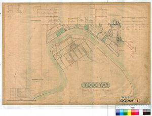
The Toodyay valley was first explored by Ensign Robert Dale in 1831. People started settling there in 1836. The first place for the town of Toodyay was chosen in 1836, and its exact borders were set in 1838. The town was officially mapped out in 1849.
However, after some big floods, people decided to move the town to higher ground. In 1860, a new town called Newcastle was built about 3 miles (4.8 km) further up the river. Later, in 1910, Newcastle was renamed Toodyay. That's when the original site became known as West Toodyay.
Contents
The First Toodyay Town
The first town of Toodyay was built next to the Avon River. This spot was chosen because the valley had gentle slopes and rich soil, with hills all around. Governor James Stirling picked this location in 1836. The town's boundaries were officially set in December 1838.
Not much building happened until the first official survey was done. Assistant Surveyor Arthur Hillman completed this survey in September 1849. At that time, the Avon River was flooding! Most of the town's growth happened along the right side of the Avon River. River Terrace followed the river's curve and had six streets crossing it.
The town grew faster after the convict era began. The Toodyay Convict Hiring Depot was set up in the town in 1851. Three inns (like hotels) were built: The Royal Oak, The Highland Laddie, and The Queen's Head. Many homes, shops, schools, and a church were also built.

A second Royal Oak inn, owned by John Herbert, became a very important place for social events. In November 1853, the Toodyay, Northam, and Victoria Plains Agricultural Society was formed there. This group held its yearly events, including an Annual Show, at the Royal Oak.
Many years later, this group became the Toodyay Agricultural Society. It's now a tradition for the Governor of Western Australia and other important people to attend the Toodyay Agricultural Show every October.
In 1852, the Toodyay Convict Hiring Depot moved to a new and bigger site. This new spot was about 3 miles (4.8 km) upstream from the original town. After big floods in 1857 and 1859, a new town was started in 1860. This new town was built on land next to the convict depot. It was named Newcastle, after the Duke of Newcastle. The town of Newcastle was officially announced on October 1, 1860.
West Toodyay's New Name
Over the years, the name Newcastle in Western Australia caused confusion. People often mixed it up with Newcastle in New South Wales. So, on May 6, 1910, the town of Newcastle in Western Australia was renamed Toodyay. The original town of Toodyay then became known as West Toodyay.
In 1920, the West Toodyay School closed down. Its 24 students moved to the Toodyay school. This was part of a plan to have "consolidated schools," which meant bigger schools were thought to be better for children's learning. In 1928, the West Toodyay school building was sold and moved away.
Railway Connections
The area called "West Toodyay" was an important spot on the Western Australian Government Railways narrow gauge railway system. It was where the Clackline-Miling railway turned north and crossed the Avon River.
When the standard gauge railway line was built through the Avon Valley in 1966, West Toodyay became a junction. This meant the older narrow gauge Miling railway connected with the newer standard gauge system here. There was also a large area for sorting trains called a marshalling yard.
Today, the West Toodyay yard is used as a local council depot. It's also a place where trains can pass each other (a crossing loop) and where the Miling railway still heads north over the Avon River.
For a while, during the time of the Spirit of the West train service, this location was also known as the Avon Siding. This was because the main Toodyay railway station didn't have a place for trains to cross or switch tracks.
Important Historic Places
The West Toodyay area is very important historically. It has a lot of aesthetic (beautiful) and social value. The local council lists it as having "considerable" significance.
Some of the important historic places in West Toodyay include:
- Church of Sancta Maria
- Everett's Cottage
- Ford crossing
- James Forbes' store (a historic shop)
- Reserve and well (a public area with a water source)
- Samuel Ferguson's cottage
- The Highland Laddie (a former inn)
- The Queen's Head (another former inn)
- The Royal Oak (1849–1851) (the first Royal Oak inn)
- The Royal Oak (1853–1860) (the second Royal Oak inn)
- Toodyay Barracks (military buildings)
- Toodyay Convict Hiring Depot (1851) (where convicts were managed)
- Toodyay Gaol (the old jail)
- Toodyay Valley School
- West Toodyay Bridge
- West Toodyay School
 | Valerie Thomas |
 | Frederick McKinley Jones |
 | George Edward Alcorn Jr. |
 | Thomas Mensah |


