Munising Township, Michigan facts for kids
Quick facts for kids
Munising Township, Michigan
|
|
|---|---|

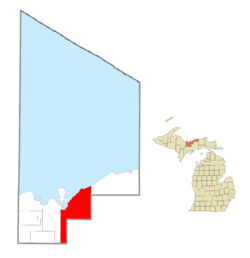
Location within Alger County
|
|
| Country | |
| State | |
| County | |
| Established | 1867 |
| Area | |
| • Total | 217.7 sq mi (563.8 km2) |
| • Land | 202.2 sq mi (523.7 km2) |
| • Water | 15.5 sq mi (40.1 km2) |
| Elevation | 850 ft (259 m) |
| Population
(2020)
|
|
| • Total | 2,865 |
| • Density | 14.8/sq mi (5.7/km2) |
| Time zone | UTC-5 (Eastern (EST)) |
| • Summer (DST) | UTC-4 (EDT) |
| ZIP code(s) | |
| Area code(s) | 906 |
| FIPS code | 26-56220 |
| GNIS feature ID | 1626781 |
Munising Township is a community located in Alger County, Michigan, in the United States. In 2020, about 2,865 people lived here.
Contents
Exploring Munising Township's Location
Munising Township is a large area in Michigan. Most of it is land, about 523.7 square kilometers (202.2 square miles). A smaller part, about 40.1 square kilometers (15.5 square miles), is water.
The city of Munising is right next to the township. However, it is a separate city with its own government.
Small Communities in the Township
Munising Township is home to several smaller communities and historic spots. Each has its own unique story:
- Camp Cusino is a state prison located near Shingleton.
- Doty is a historic spot where two old railway lines used to meet. It was named after Marcus A. Doty, a railway manager.
- Gogarnville was once a post office here from 1889 to 1893.
- Hallston was another former post office and railway station. It was first called "Anna River" in 1888. Later, it was renamed Hallston.
- Indian Town is a place located at Old Indian Town and Indian Town Road.
- Juniper is a spot found near the Coalwood Recreation Trail.
- Kentucky is a place on Doe Lake Road.
- Melstrand is a small community with a history as a sawmill village. It also had a railway station and a post office for a few years.
- Myren is another small place within the township.
- Petrel was a lumber settlement with a post office that operated in the early 1900s.
- Reedsboro was a former post office and railway station in the 1880s.
- Shingleton is a community about 10 miles (16 km) southeast of Munising. It was first called "Jeromeville" after a Michigan governor. Later, it was renamed Shingleton because of a local shingle mill. The Michigan Department of Natural Resources has a wildlife research station here.
- Star, also known as Star Siding, is a community located on M28.
- Van Meer is another place within the township.
- Wetmore is a community about 2 miles (3 km) southeast of Munising. It started as a settlement called "Floeter." It was renamed Wetmore in 1895 after William L. Wetmore, a local businessman.
Population and People
Munising Township has seen its population change over the years.
| Historical population | |||
|---|---|---|---|
| Census | Pop. | %± | |
| 1960 | 1,408 | — | |
| 1970 | 1,614 | 14.6% | |
| 1980 | 1,963 | 21.6% | |
| 1990 | 2,193 | 11.7% | |
| 2000 | 3,125 | 42.5% | |
| 2010 | 2,983 | −4.5% | |
| Source: Census Bureau. Census 1960- 2000, 2010. | |||
In 2000, there were 3,125 people living in the township. By 2020, the population had slightly decreased to 2,865.
Most people in the township are of European descent. Some common backgrounds include American, French, German, Finnish, Polish, Irish, French Canadian, and English ancestry.
In 2000, about 37% of households had children under 18 living with them. The average household had about 2.74 people. The median age in the township was 35 years old. This means half the people were younger than 35, and half were older.
Income and Economy
In 2000, the average income for a household in Munising Township was about $40,946 per year. For families, the average income was around $45,114. By 2021, the estimated average household income was $48,203.
A small number of families and individuals lived below the poverty line. This included about 9.8% of those under 18 years old.
See also
 In Spanish: Municipio de Munising para niños


