
Wheeler Heights, New South Wales facts for kids
Quick facts for kids Wheeler HeightsSydney, New South Wales |
|||||||||||||||
|---|---|---|---|---|---|---|---|---|---|---|---|---|---|---|---|
| Population | 2,986 (2016 census) | ||||||||||||||
| Postcode(s) | 2097 | ||||||||||||||
| Elevation | 87 m (285 ft) | ||||||||||||||
| Location | 22 km (14 mi) from Sydney CBD | ||||||||||||||
| LGA(s) | Northern Beaches Council | ||||||||||||||
| State electorate(s) | Pittwater, Wakehurst | ||||||||||||||
| Federal Division(s) | Mackellar | ||||||||||||||
|
|||||||||||||||
Wheeler Heights is a friendly suburb in Northern Sydney, Australia. It's located about 22 kilometres north-east of the main city centre of Sydney. This area is part of the Northern Beaches region and is looked after by the Northern Beaches Council.
Wheeler Heights became its own official suburb in 1977. However, in 1984, it was changed to just a "locality" within Collaroy. After a lot of effort from the local community, Wheeler Heights was officially made a suburb again in 2011. People living there had always thought of it as a separate suburb!

Contents
A Journey Through Time in Wheeler Heights
Early Days and Aboriginal Heritage
The area around Wheeler Heights has a rich history. Long before European settlers arrived, it was home to Aboriginal people. There are over 1000 important Aboriginal cultural sites in the wider Sydney region, including the Northern Beaches. This shows how important this land has been for thousands of years.
For a long time, the Warringah area, which includes Wheeler Heights, was mostly countryside. It was quite isolated and had tricky land, which made it harder to develop.
The Wheeler Family Story
One of the first European families to settle here was the Wheeler family, from England. James Wheeler bought 150 acres of land in 1842. This land was near South Creek and Narrabeen Lagoon. His family lived there for over 100 years.
The Wheeler family home was a well-known sight on the southern side of Narrabeen Lagoon. You can still see parts of a stone wall from their old farm sticking out of the shoreline near James Wheeler Place. The Wheeler Estate was divided up after World War II.
How Wheeler Heights Got Its Name
The name "Wheeler Heights" comes from the Wheeler family. You'll also find James Wheeler Place named after them. Many other street names in Wheeler Heights are inspired by places in the Lake District in England. For example, Derwent St, Coniston St, and Windermere Place are named after lakes. Ambleside St and Penrith Ave are named after towns.
A School's Influence on the Name
In 1961, a school called Collaroy Plateau West Primary School was built. For years, school buses often went to the wrong school because its name was so similar to Collaroy Plateau Primary School.
To fix this, in 1969, the school's name was changed to Wheeler Heights Public School. This idea came from a teacher, Stan Walters, who was interested in local history. After this, "Wheeler Heights" became the common name for the streets around the school. It was also used for the shops on South Creek Road.
In 1977, Wheeler Heights was officially registered as a suburb. However, in 2002, it lost its suburb status and became an "urban place." But the community fought hard! In 2010, their "Save our Suburbs" campaign worked, and Wheeler Heights became a suburb again.
The Superb View Estate
Back in 1917, a real estate developer named Sir Arthur Rickard advertised the "Superb View Estate." This estate created new land lots for homes on streets like Lantana Avenue, Rose Avenue, and Veterans Parade (which used to be Plateau Road).
Fun Places to Explore
Jamison Park
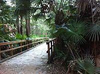
Jamison Park is a large natural area, about 42.8 hectares in size. It's located along the southern edge of Narrabeen Lagoon. You can get to it from Wheeler Heights via James Wheeler Place and South Creek Road. It's a great spot for outdoor activities.
Narrabeen Lagoon Trail

Imagine walking, cycling, or jogging around a beautiful lagoon! On February 25, 2015, the final part of the Narrabeen Lagoon Bush Trail was opened. This amazing trail is 8.4 kilometres long and goes all the way around Narrabeen Lagoon.
The trail includes two steel bridges and runs next to the Sydney Sports Academy. It's a safe and enjoyable way to be close to nature and see the stunning views of Narrabeen Lagoon.
Parks and Green Spaces
-
South Creek Reserve is accessed from South Creek Rd and James Wheeler Place. It is part of the Narrabeen Lagoon Bush trail.
-
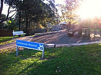
Ambleside Reserve is accessed from Ambleside St. There is a playground.
-
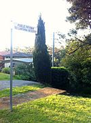
Lantana Reserve is accessed from Greystoke St. via steep steps to an undeveloped bushland area.
-
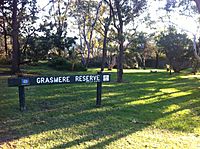
Grasmere Reserve is accessed via Grasmere Cres. There is a playground.


Amazing Native Plants


The Northern Beaches area, including Wheeler Heights, is home to over 900 different types of native plants! These plants grow in various places, from sandy coastal areas to rocky hills.
Wheeler Heights has "dry sclerophyll forests." These forests are filled with unique Australian plants like waratahs, banksias, wattles, and tea-trees. The ground usually has a few sedges and grasses, growing in sandy soil that isn't very rich in nutrients.
Getting Around and Local Services
Transport Options
Most people in Wheeler Heights use private cars to get around. However, public buses are also available. The 179 bus route serves Wheeler Heights, connecting it to Warringah Mall and the War Veterans retirement village. There isn't a train station in Wheeler Heights; the closest one is in Roseville.
Schools and Community Places
Wheeler Heights has one church, St Rose Catholic Church.
There are also two schools in the suburb:
- Wheeler Heights Public School
- St Rose Catholic Primary School
For younger children, there is also a Long Day Care Centre.
Local Shops
Wheeler Heights has a shopping centre on South Creek Road. This centre includes the Wheeler Heights Post Office. In recent years, the shopping centre has been redeveloped. It now has shops and restaurants on the ground floor, with apartments above and underground parking for residents.
