Whimpton Village facts for kids
Quick facts for kids Whimpton Village |
|
|---|---|

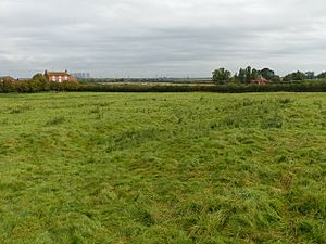
Looking north-east across the site. The ditch running away from the camera is a roadway separating the village on the left from a field on the right.
|
|
| Location | Nottinghamshire |
| OS grid reference | SK 791 739 |
| Designated | 13 February 1953 |
| Reference no. | 1017567 |
| Lua error in Module:Location_map at line 420: attempt to index field 'wikibase' (a nil value). | |
Whimpton Village is a special place in Nottinghamshire, England. It's what we call a "deserted medieval village." This means it was once a busy village long ago, but now only its old foundations and paths remain, hidden under the ground. It's protected as a Scheduled Monument, which is like a historical treasure site. You can find it near the A57 road, between the villages of Darlton and Dunham-on-Trent.
Contents
What Happened to Whimpton Village?
Whimpton Village has a long history! It was first written about in the Domesday Book. This was a huge survey ordered by William the Conqueror in 1085. In the book, Whimpton was called "Wimentun." It was part of the King's larger estate in Dunham.
How We Know About Its Past
Old records called "pipe rolls" also mention the village. These records from the 1100s, 1200s, and 1300s talk about the land and people living there. But by the year 1547, the village had disappeared. An official document from that year only mentioned Whimpton as a field name. This tells us the village was no longer a living community.
Exploring the Village Remains
Today, you can still see the remains of Whimpton Village. These are mostly "earthworks," which are shapes and bumps in the ground. They show where buildings and paths used to be. Most of these earthworks are in a field south of the modern A52 road. Some smaller parts are north of the road, near Whimpton House.
Old Roads and Paths
In the main field, there's a wide, old roadway. It runs from west to east across the hill. This path was once a main street in the village. South of this old road, you can see signs of where people used to farm the land.
Two other roads branch off the main one. They wind their way north towards the A57 road. The eastern road goes past the modern road. It leads to a rectangular area that was once a special home. This area was about 38 meters (125 feet) long and 23 meters (75 feet) wide. It was surrounded by a wide ditch, about 7.5 meters (25 feet) across. Historians think this was a "moated homestead," a home protected by a ditch filled with water.
Where Houses Once Stood
In the field south of the modern road, you can see rectangular shapes. These are marked by low banks and ditches. Each shape has a slightly raised platform inside. These are the remains of medieval houses. They show us where the walls and foundations of homes once stood.
The Village Green
Between the two roads that run north, there's a large open area. It's about 61 meters (200 feet) long and 46 meters (150 feet) wide. This area is marked by low banks on three sides. It faced the widest part of the main village road. Experts believe this was the village green. This was a central open space where people would gather. There are no building remains here, but there are two hollows. These might have been ponds for the village.
Ancient Farmland Patterns
Around the village, you can see a special pattern in the fields. It's called "ridge and furrow." This pattern looks like waves in the ground, about 0.5 meters (1.6 feet) high. It's a sign of how farmers used to plow their fields in the medieval "open-field system." This system helped them share and farm the land together.
 | Dorothy Vaughan |
 | Charles Henry Turner |
 | Hildrus Poindexter |
 | Henry Cecil McBay |

