
White Hall, Alabama facts for kids
Quick facts for kids
White Hall, Alabama
|
|
|---|---|

White Hall Town Hall
|
|

Location of White Hall in Lowndes County, Alabama.
|
|
| Country | United States |
| State | Alabama |
| County | Lowndes |
| Area | |
| • Total | 15.54 sq mi (40.24 km2) |
| • Land | 15.32 sq mi (39.67 km2) |
| • Water | 0.22 sq mi (0.57 km2) |
| Elevation | 184 ft (56 m) |
| Population
(2020)
|
|
| • Total | 806 |
| • Density | 52.62/sq mi (20.32/km2) |
| Time zone | UTC-6 (Central (CST)) |
| • Summer (DST) | UTC-5 (CDT) |
| FIPS code | 01-81912 |
| GNIS feature ID | 0153961 |
White Hall is a small town in Lowndes County, Alabama, United States. It is part of the larger Montgomery area. The town got its name from a plantation that was destroyed by a tornado in 1882.
White Hall was started in 1935 during the Great Depression. This was a time when many people struggled to find jobs and homes. The town was part of a special government program called the New Deal. This program helped build new communities. White Hall was created for African-American families living in the area. The town officially became a town in 1979.
Contents
Where is White Hall Located?
White Hall is located in the state of Alabama. You can find it at these coordinates: 32 degrees, 18 minutes, 50 seconds North and 86 degrees, 42 minutes, 50 seconds West.
White Hall's Size
The town covers a total area of about 15.5 square miles (40.2 square kilometers). Most of this area is land. A very small part, about 0.1 square miles (0.57 square kilometers), is water.
Who Lives in White Hall?
The number of people living in White Hall changes over time. In 2010, there were 858 people. By 2020, the population was 806.
| Historical population | |||
|---|---|---|---|
| Census | Pop. | %± | |
| 1970 | 367 | — | |
| 1980 | 251 | −31.6% | |
| 1990 | 814 | 224.3% | |
| 2000 | 1,014 | 24.6% | |
| 2010 | 858 | −15.4% | |
| 2020 | 806 | −6.1% | |
| U.S. Decennial Census 2013 Estimate |
|||
White Hall's Diverse Community
White Hall is home to people from different backgrounds. In 2020, most residents were Black or African American. There were also White residents and people of mixed races. A small number of residents identified as Hispanic or Latino.
Famous People from White Hall
- Ben Wallace is a famous basketball player who grew up in White Hall. He played in the NBA.
Images for kids
-
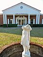
White Hall Town Hall
-
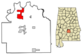
Location of White Hall in Lowndes County, Alabama.
See also
 In Spanish: White Hall (Alabama) para niños
