
White Pine Range facts for kids
The White Pine Range is a group of mountains located in eastern Nevada, specifically in the southern part of White Pine County. These mountains stretch for about 51 miles (82 km) from Beck Pass in the north to Currant Pass in the south.
To the west of the White Pine Range, you'll find the lands of the Duckwater Shoshone tribe and the northern part of a large area called Railroad Valley. To the east are Jakes Valley and the northern section of the long White River Valley. South of the range are the Horse and Grant Ranges.
The White Pine Range is part of the huge Humboldt-Toiyabe National Forest. This forest is managed by the United States Forest Service, which is a part of the U.S. Department of Agriculture. They help protect and care for these natural areas.
Contents
Exploring the White Pine Range

Two important roads cross the White Pine Range. U.S. Route 50, often called the "Loneliest Road in America," goes over the northern part of the range at Little Antelope Summit. This summit is 7,433 feet (2,265 meters) high. Further south, U.S. Route 6 crosses the range at Currant Summit, which is 6,999 feet (2,133 meters) high. The very southern edge of the range even reaches into northeastern Nye County.
Famous Peaks and Wild Areas
The White Pine Range is home to several tall mountains. Near Highway 50, you'll find the historic mining area of Hamilton. Close by is Mount Hamilton, standing at 10,745 feet (3,275 meters).
The southern part of the range features a thin ridge made of limestone. This is where the highest point of the range, Currant Mountain, is located. Currant Mountain reaches an impressive 11,513 feet (3,509 meters) into the sky. Other tall peaks in this area include Duckwater Peak (11,188 feet, 3,410 meters) and White Pine Peak (10,182 feet, 3,103 meters).
Protecting the Wilderness

This high section of the range is a protected area known as the Currant Mountain Wilderness Area. Wilderness areas are special places where nature is left wild and untouched. The eastern slopes of this wilderness area are where the White River begins its journey.
Just south of the Currant Mountain Wilderness is another protected area called the White Pine Range Wilderness Area. This area covers about 40,013 acres (162 square kilometers) and helps protect even more of the beautiful White Pine Range.
Amazing Bristlecone Pines

Even though the range is named after the Limber Pine, it's truly famous for its large and strong groups of Great Basin Bristlecone Pines. These trees are known for being some of the oldest living things on Earth!
You can find both young and very old Bristlecone Pines at elevations above 10,000 feet (3,048 meters), all the way up to the top of Currant Mountain. These amazing trees can live for thousands of years, surviving in harsh mountain conditions. They are a true wonder of nature in the White Pine Range.
Images for kids
-
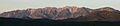
The southern White Pine Range, looking west at sunrise.
